
Extreme Temperatures
S


Bizarro Earth

'Double El Niño? Rare weather phenomenon about to change our world?

We're about to experience a "double El Niño" — a rare weather phenomenon that climatologists had warned about several months ago. That means two consecutive years of the concentration of warm water in the Pacific Ocean that brings West Coast storms, quiet hurricane seasons in the Atlantic and busy ones in the Pacific. The danger is that this could mean more than a few months of odd weather, but instead usher in a new phase of climate change. Last year was the warmest year on record; 2015 looks set to be even warmer. "One way of thinking about global warming from the human influences is that it's not just a gradual increase, but perhaps it's more like a staircase, and we're about to go up an extra step to a new level," says climate scientist Kevin Trenberth of the National Center for Atmospheric Research.
Image
Normally, the warm water from an El Niño spreads across the Pacific and cools as it evaporates. The increased moisture in the air leads to thunderstorms and tropical storms. That hasn't happened as much as anticipated over the last year. "The moisture in the atmosphere triggers a lot of thunderstorms and tropical storms, but in general that atmospheric connection has not been anything like as strong as we normally expect in El Niño events, and as a result, the warm water is sort of sitting there, and it hasn't petered out," Trenberth explains. "The energy has not been taken out of the ocean, and there's a mini global warming, so to speak, associated with that." What kind of temperature increase are we talking about? Trenberth says it could mean a rise of two- or three-tenths-of-a-degree Celsius, or up to half a degree Fahrenheit. The change could occur "relatively abruptly," but then stick around for five or 10 years. While those numbers may seem small, in the context of global climate, a shift of that magnitude could have devastating consequences.

Comment: Ignoring the silly 'global warming' bent of this article, there is something we actually should be worried about: 'The Day After Tomorrow' just got one step closer to reality!


Snowflake

Snow covers streets and palm trees in Baljurashi, Saudi Arabia

Image
Snow on the palm.
This video clip posted on "YouTube" shows streets, yards and homes of the province covered with snow last Friday.


Here is a collection of photos taken from social networking sites showing mountains, hills and forest covered with snow.

Image
Snow in Saudi Arabia

Snowflake

Snowstorm paralyzes transportation system in Oslo, Norway

Image
Bus in Oslo.
Oslo's bus system shut down, trams weren't running, some trains stood still and Norway's gateway airport at Gardermoen, north of Oslo, finally had to close. Warnings had been issued about Thursday's snowstorm, but it proved to be more than transport systems could handle.

The blizzard that began during the night and built up during the morning had dumped more than 40 centimeters of snow on the southern coastal town of Arendal by midday. Some areas reported more than 60 centimeters and it was still coming down. Streets that did get cleared were covered with slippery snow again within minutes.

At Oslo's main airport at Gardermoen, the snow was falling so thick and fast that the airport's army of plows were out in force trying to keep the runways clear, but without much luck. "And when we have plows on the runways, planes can't land or take off," airport spokesman Joachim Wester Andersen told Norwegian Broadcasting (NRK).

Ice Cube

Deep freeze over the Great Lakes halts cargo shipments

Image
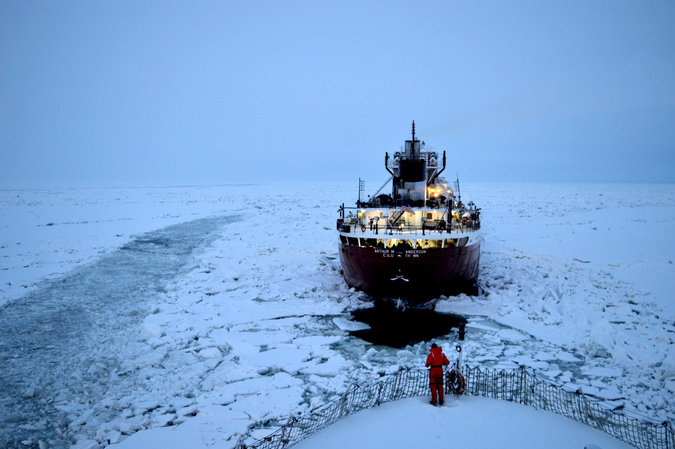
© Canadian Coast Guard The ship Arthur M. Anderson got underway on Lake Erie on Saturday after getting help from Canadian Coast Guard icebreakers.
The trip to pick up a load of iron ore powder in Conneaut, Ohio, was supposed to take four days by way of the Great Lakes.

But within sight of its destination, the cargo ship, the Arthur M. Anderson, got trapped in ice. Two heavy icebreakers from the Canadian Coast Guard eventually broke the vessel free.

It was a 24-day ordeal, and the ship returned to its home port in Wisconsin without picking up the cargo.

A deep freeze this winter left much of the Great Lakes blanketed in thick ice, sidelining the ship lines and companies that move vast amounts of grain, cement and other commodities through this system of waterways. And now the spring thaw, which creates piles of impassable ice, will most likely create more delays.

"There's a lot of ice out there, and we need to understand the impact of that ice," said Mark Barker, the president of the Interlake Steamship Company, which carries mostly iron ore, coal and limestone on its nine ships. "Last year, we pretty much lost the month of April."

Cloud Lightning

Best of the Web: Extreme weather, meteor fireballs, and Earth Changes in March 2015 (VIDEO)

Image
© HawkkeyDavisChannel
Earth changes have taken place the past few weeks or so. Animals are listed among the dead.

I've been working 50+ hours a week, sorry if there's any mistakes. Thanks for watching and stay safe..

This series does not mean the world is ending! These are documentaries of series of extreme weather events which are leading to bigger earth changes. If you're following the series, then you're seeing the signs. It's much more than one video!


Follow me on Facebook for much more

Cloud Precipitation

Giant hailstones fall in Queensland, Australia

Image
This shard of hail measuring about 12 centimetres crashed down in Chinchilla on Saturday afternoon
Weather watchers around the world have been stunned by giant chunks of ice that smashed an outback Queensland town in recent days.

Hailstones up to 12cm in diameter smashed cars and windows and left lawns checkered in the western downs town of Chinchilla during a freak storm on Saturday afternoon.

The downpour that stunned the state has now attracted interest overseas, with many in the US shocked at the "weird" weather that no one saw coming.

Some have pointed out the hailstones were about the same size as the small marsupials the town shares a name with.

"Shocking footage," wrote Keith Estiler, a New York City resident who shared video of the giant balls of ice bouncing off an oval in Chinchilla.


Comment: See also: Large hailstones kill horses, birds and ravage cotton crops in northern New South Wales, Australia


Snowflake

250 villages cut off by heavy snowfall in Turkey

Image
Snow removal in Turkey.
In Hozat and Ovacik snowfall exceeded half a meter (20 inches), says this article on gercekgundem.com. And there is 20 cm (8 inches) of snow in the city center of Pülümür.

Normal life in Tunceli is stopped

Due to the increasing snowfall during the night in Tunceli, the Tunceli-Pülümür and Tunceli-Erzincan highways remained closed to traffic due to the dozens of vehicles stuck on the road.

A large number of machines were sent to the area to open roads. Meanwhile, Tunceli-Hozat, it was learned that the Tunceli-Ovacik road transport in closed due to snow.

About 250 villages are cut off.

Snowflake

First day of Spring brings blanket of snow to Northern Virginia, Massachusetts

Image
© Accuweather/junebug
A storm spreading rain across the South this week will take a northward jog and spread snow to part of the Interstate-95 and I-81 corridors of the Northeast on Friday.

Spring officially arrives on Friday, March 20, at 6:45 p.m. EDT, but Old Man Winter may have the last laugh.

Colder air will invade the Northeast during the middle days of the week, and the atmosphere is likely to remain just cold enough for some wet snow before the week draws to a close.
Image
Despite the colder air, temperatures will be marginal for the storm with a close call between rain and snow along the I-95 corridor in the mid-Atlantic, Long Island and along the southern coast of New England. Much of the snow that falls in this area may melt on roads. However, there will be some exceptions.

A wintry mix of rain and snow is most likely in Baltimore, Washington, D.C., Philadelphia, Wilmington, Delaware, and Trenton, New Jersey. The storm is likely to impact travel in this area, including the potential for flight delays due to poor visibility and deicing operations. Motorists and pedestrians should be prepared for delays on Friday.

Areas farther north such as Harrisburg, Allentown and Scranton, Pennsylvania; New York City and White Plains, New York; Hartford, Connecticut; and Boston are likely to be cold enough for all or mostly snow. Airline delays due to deicing and poor visibility are likely in the New York City area and perhaps as far north as Boston. Most areas within this swath will receive 1-3 inches of snow with the greatest amount on non-paved surfaces.
Comment: See the latest SOTT video summary on the extreme weather we are having on the planet.


Ice Cube

As snowfall records are set, ferry becomes stuck in sea ice off Nova Scotia

Image
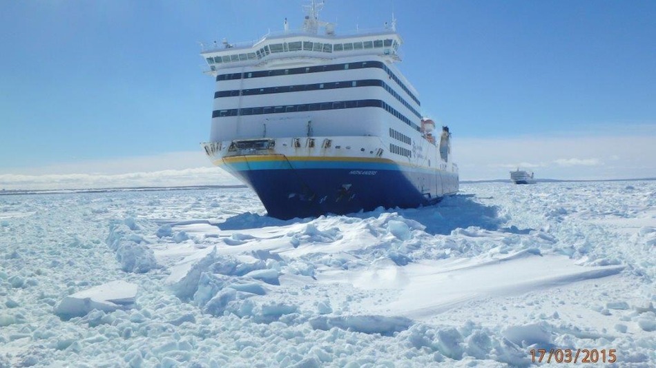
© Twitter/@MAFerriesThe MV Highlanders pictured from a Canadian Coast Guard vessel in Cabot Strait on March 17, 2015.
While the all-time snowfall record in Boston may have received most of the media attention in the U.S., Canada has had its fair share of unusually severe winter weather this season as well.

Nova Scotia, Prince Edward Island and Newfoundland have been slammed by back-to-back-to-back-to-back (you get the point) severe winter storms, producing a broad area of sea ice cover and mountainous snowbanks along the streets of cities such as Charlottetown and Saint John.

A Marine Atlantic passenger ferry with 190 people aboard was stuck in pack ice off Cape Breton, Nova Scotia, on Tuesday, with Canadian Coast Guard ships trying to free the vessel. According to the Canadian Press, the MV Highlanders ran into heavy ice on Monday night, after leaving North Sydney, Nova Scotia, for Port aux Basques, Newfoundland.
#CCG Louis S St-Laurent assisting MV Highlanders and Blue Puttees in Cabot Strait. Slow progress in very thick #ice. pic.twitter.com/Do2HeFWiVW

— DFO_NL (@DFO_NL) March 17, 2015

In a statement to passengers, Marine Atlantic warned of travel delays.

Chalkboard

200-pound ice boulder crashes through apartment roof in Wilmington, Massachusetts

Image
© Wilmington Police Department
A huge chunk of ice crashed through the roof of a Wilmington Apartment building on Sunday. Luckily nobody was hurt.

The ice boulder weighing about 200 pounds landed in the back stairwell of the Avalon Oaks Apartments. Residents who were home when it happened say they heard a huge 'bang' when the ice came crashing through the ceiling.

"It was like this big," Kathleen Trowbridge said, holding her arms the width of her doorway, "and it just came through solid. It didn't break up." She then called 911.

Wilmington Police say the giant ice block fell from the highest part of the apartment building's roof, crashing onto a lower roof and through the back stairwell, leaving a gaping hole.

"Luckily nobody was there," a male resident said. "That was the most important thing. If somebody had been hit by that, they'd probably be dead."

Residents say that maintenance crews did shovel off the roof from past storms, but the ice buildup did not go away. Some are still concerned.

"If it's going to happen here, is going to happen in the front?" Trowbridge questioned. "There's icicles up there."

"I'm just very disappointed and very nervous for my health, for my kids' health," another resident voiced.