Extreme Temperatures
S


Snowflake Cold

Qinghai-Tibet Plateau receives biggest early winter snow since records began 57 years ago - 7 inches measured

The Qinghai-Tibet Plateau
Continuous snow has swept Qinghai Province in northwest China since the start of November, accumulating record high precipitation in the region's 57 years of history of meteorological records.

Snow accumulation between Nov. 2 and 7 has reached 18 cm on the ground in Dulan County, Haixi Mongolian Tibet Autonomous Prefecture, where the height above mean sea level averages 3,180 meters.

The Qinghai-Tibet Plateau, known as the "roof of the world," is an important region to monitor climate changes with the weather and the glaciers as indicators.

Snowflake

Michigan snow totals already starting to mount up - maximum of 34 inches measured

Snowfall so far in 2018-2019
© NOAA/National Snow AnalysesSnowfall so far in 2018-2019 cold season as of November 19. 2018
A few weather systems with Michigan on the cold side of the storms and some lake effect snow have made most of Michigan have above normal snowfall so far in the early part of this cold season.

The eastern Upper Peninsula has the most deviation from normal snowfall amounts. Sault Ste. Marie has already shoveled 26.7 inches of snow. This is 17.7 inches more than normal to this date.

Marquette is on the fast track to 100 inches of snow, with 34 inches of snow already falling in this early part of the cold season. Marquette is 15 inches above snowfall normal today.

Here's a rundown of how much snow has fallen as of November 19, 2018 and the departure from normal.

Binoculars

Snowy owls expected to show up again this winter in USA - 8th consecutive season in an unusual sequence

Snowy owl
Snowy owl
After multiple sightings last winter, including some in Hancock County, snowy owls are again being seen in Indiana, according to the Indiana Audubon Society.

The all-white arctic owl only visits Indiana during cyclical "irruptions" occurring every four to five years, but often the year following an invasion, such as occurred last winter, can produce an "echo effect," bringing another smaller invasion of owls southward, the organization says in a news release.


Comment: This standard explanation of cyclical irruptions has broken down for the last 7 winters, when exceptional numbers appeared every year. See the links below covering the time period which amply demonstrate this point. Some other environmental and/or climate factors seem to be involved.


Snowy owl numbers fluctuate year to year based on their primary prey — lemmings, giant mouse-like rodents — whose population also oscillates based on food supplies and weather conditions in the arctic. When populations spike, the owls respond with higher than normal breeding, with some nests containing ten or more eggs. The subsequent invasions later that fall result in not so much a food scarcity, but because of the abundance of food earlier that summer. Young owls tend to leave the arctic each winter, resulting in the larger-than-normal invasions.

Comment: A sample of the many reports for the last 7 seasons:

Winter 2017-18: Highest number of snowy owls ever recorded of 139 in 2017-18 winter across Indiana

Record number of 280 snowy owls counted in Wisconsin this winter

Winter 2016-17: At least 65 Snowy owls invade Bruce County, Ontario

Winter 2015-16: 30 Arctic Snowy owls arrive in Wisconsin; earliest date ever reported and record numbers

Winter 2014-15: An above average winter for sightings of snowy owls in Northeast America

Snowy owl sightings on the rise across the upper US

Winter 2013-14: Huge Snowy Owl invasion becomes official in Canada and U.S.

Winter 2012-13: Mysterious snowy-owl migration one of biggest on record

Winter 2011-12: US: Snowy owls soar south from Arctic in rare mass migration


Snowflake Cold

Adapt 2030 Ice Age Report: (NASA) What they mean about Earth cooling and atmosphere shifting

Snow
More articles out about our planet cooling for a decade or two before the global warming march continues in 2030's. NASA saying look out for global cooling, beer prices doubling, 40 foot waves rip apart apartments Canary Islands, 30F below normal record breaking temperatures on tap for Canada and USA plus ice storms and crop destroying fronts in Asia.


Sources

Comment: View video: Enormous waves wipe away balconies in Tenerife, Canary Islands


Snowflake

Spring snow blankets lower South Island, New Zealand with more on the way

Snow at Arthurs Point near Queenstown on Monday morning.
© DEBBIE JAMIESON/STUFFSnow at Arthurs Point near Queenstown on Monday morning.
Snow has fallen to 400 metres in lower parts of the South Island and thunderstorms could be on the cards for the top half.

MetService duty forecaster Bill Singh said an unstable southerly flow is the culprit behind the snow.

"As we move towards the day, the snow level is expected to rise to about 600 metres," he said.

"There has been a warning out for central Otago, inland Clutha and Southland for snow ... to [fall] to 800 metres where between 30 to 40 centimetres of snow is expected to accumulate."


Snowflake

Heavy snow brings traffic to a halt in eastern Turkey - up to 31 inches measured

snow
Three days of heavy snowfall has brought life to a standstill in Kurdish areas of Turkey.

"We are waiting for the roads to be reopened. Winter has come and we are stuck on the roads," said one driver in Kars province putting chains on his tires.

Nearly 80 cm of snow has fallen in Kars and 50 cm in other provinces.

And it is still coming down.


Comment: See also this report from 3 days earlier: Heavy snowfall in Turkey - up to 2 feet.


Snowflake Cold

Adapt 2030 Ice Age Report: Real reason winter Avery formed so early - our sun is changing

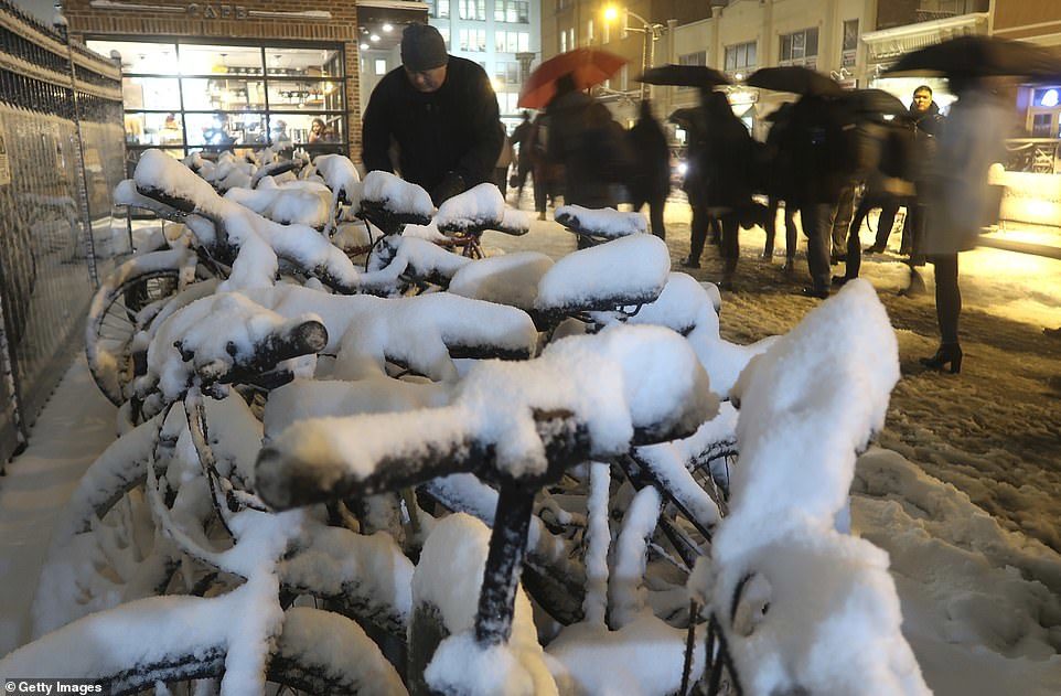
Snow piles up on bicycles outside the transit terminal in Hoboken, New Jersey, after a snowstorm on Thursday
The real reason for Winter Storm Avery in Autumn breaking thousands of snow and cold records is that our Sun is changing as it always does on its 400 year cycle called a Grand Solar Minimum.

This affects global grain yields and food prices. If you think New York's old snow record was one inch and the new record is 6.2 inches, that's not CO2 its a new effects from our Sun on our magnetosphere and cloud patterns around Earth.

From record rains, to record snow and cold, this is the new era we are entering and I try to explain it the best I can using the Avery Winter Storm to show cause and effect.


Sources

Snowflake

Early snowfall continues in northern and central Greece

Agios Pavlos village in Vermio mountains, Naoussa.
As the temperature continues to plummet across Greece, the snowfall as accumulated in many mountainous areas in Macedonia, Thessaly, and Thrace on Saturday morning.

People in mountainous villages in Florina, Naoussa, Pelion, Trikala, Grevena, Metsovo and even as south as Nafpaktia and Arcadia woke up and found everything covered in snow, with meteorologists predicting that the temperatures will remain low until Monday.


Snowflake

Man-made global warmists predicted no snow. Instead, we're getting record snow falls

Snow
"I believe in the science" is the new catechism of the global warming idiot, who does not want to think and treats doubt as an enemy.

So what do these wilfully incurious believers say now that the heavens have opened up (again) with massive snow falls over the European Alps and north-eastern United States?

See, for 20 years, the top global warming alarmists were warning us there would be no snow.

In 2000, for instance, came this famous prediction from the then centre of global warming alarmism:
According to Dr David Viner, a senior research scientist at the climatic research unit (CRU) of the University of East Anglia, within a few years winter snowfall will become "a very rare and exciting event".

"Children just aren't going to know what snow is," he said.

Comment: See also these recent November reports: At least 7 killed as powerful snowstorm blasts across huge swath of US

Mid-Hudson Valley hit by early snowstorm with up to 14 inches measured

Heavy snowfall in Turkey - up to 2 feet

Cold weather gives Texas earliest snowfall ever recorded - 7 inches in the Panhandle

Up to 130cm (51 inches) of snow has fallen in Labrador and winter hasn't even begun

Loveland Ski area in Colorado receives historic seasonal snowfall - almost 7 feet so far


Snowflake

At least 7 killed as powerful snowstorm blasts across huge swath of US

Pedestrians walk through snow and ice in Manhattan on November 15, 2018 in New York
The first snowstorm of the season to hit the New York City area brought several inches of snow, slowing Thursday's evening commute to a crawl, after contributing to at least seven deaths as it swept across the country.

From St. Louis to the South and into the Northeast, snow, freezing rain, and in some parts, sleet, made driving tricky and closed schools Thursday.

In New York City, the wet snowfall and wind gusts Thursday downed numerous tree branches. Police advised people to stay indoors and avoid the roads
. Commuters also were advised to avoid the Port Authority Bus Terminal - which is also used by some to travel to New Jersey - due to overcrowding.