Extreme Temperatures
S


Ice Cube

Ice Age Farmer Report: "UNPRECEDENTED" - Why harvests failed in 2018 - Learning from the past

snow crop
Food shortages are happening around the world - prices are rising - and this will continue through the Grand Solar Minimum. Prepare now. Please share this information with those you love, and those who can think critically, put the pieces together, and start building a better future.


Sources

Comment: Read also: Europe's Little Ice Age: 'All things which grew above the ground died and starved'


Snowflake

Cold snap and dust storms blanket China's far northwest in 'yellow snow'

yellow snow
Some parts of northwestern China have been blanketed by "yellow snow", a phenomenon the meteorological authority said was due to a combination of cold weather mixed with sandstorms.

Snowfalls of 10-20cm (around 4-8 inches) were reported in the region's capital Urumqi and the cities of Shihezi and Changji on Saturday.

Residents found the surface of the snow was covered with a layer of dust but white underneath, a phenomenon some compared with tiramisu.

"Since last Friday, many places in Xinjiang have been hit by gales measured at force seven or above," He Qing, director of the Xinjiang Meteorological Administration, told the Xinhua news agency.


Snowflake

Parts of New England and New York have seen a historically snowy November

snow
Much of New York and the northern half of New England have seen an extremely snowy start to the winter. Ski areas are ecstatic, though many wonder whether this is the start of an extra harsh winter.

Snowfall totals across New York and New England have surpassed one to two feet in many areas, while some places in ski country and the snowbelts off the Great Lakes are pushing three to four feet or more.

This record and near-record November snowfall has been caused by the same general weather pattern that led to record rainfall in parts of the Mid-Atlantic into eastern New England. Basically, storm systems keep on coming, riding along the jet stream that has parked itself over the region.

In addition to a stream of coastal storms this cold season, other low-pressure systems have kept the precipitation coming, as well. There have now been eight significant low-pressure systems affecting the eastern United States over the past month:

Snowflake

As much as 53 inches of snow has fallen on Mammoth Mountain, California

Mammoth Mountain
© Mammoth Mountain
Another winter storm is making its way toward Lake Tahoe where nearly 2 feet (61 centimeters) of snow already has fallen at several ski resorts and more than 4 feet (1.2 meters) is reported further south in the highest elevations of the central Sierra along the California-Nevada line.

The National Weather Service says the most recent snowfall Thursday and early Friday totaled about 20 inches (45 cm) at Northstar, Squaw Valley and Mt. Rose on the highway connecting Reno to Lake Tahoe.

As much as 53 inches (134 centimeters) of snow was reported at Mammoth Mountain ski area three hours south of Tahoe.

Precipitation has been mostly in the form of rain in the valleys, including Reno where a record .61 inch of rain fell at the airport Thursday, breaking the old record of .32 set in 2000.


Comment: It looks very likely that the forecast made on the 29th of November for 5 feet of snow to have fallen over the area in the past 3 days (and before the weekend) will actually happen. Perhaps more tellingly this is also before meteorological winter officially starts on the 1st of December (Saturday).


Snowflake

Heavy snowfall hits Athens' Parnitha Mountain

Snow continued falling throughout the night
As the temperatures continued to plummet across the country, Athens' Parnitha mountain was hit by heavy snowfall on Thursday night and Friday morning.

The mountain, located north of the Greek capital, was covered in snow from the early hours of Thursday evening, with the situation worsening throughout the night. Meteorologists say that the snowfall will continue into Friday as well.

According to forecasts, the temperatures will gradually begin to rise beginning on Saturday.


Snowflake

Winter storms bring up to 30 inches of snow to the southern Sierra - 5 feet possible before the weekend

snow
Snow at Mammoth Mountain on 28th November
The Latest on the series of winter storms bringing heavy snowfall to the Sierra and Lake Tahoe (all times local):

10:05 a.m.

More than a foot (30 centimetres) of snow has fallen at some ski resorts around Lake Tahoe.

The National Weather Service in Reno reported more than 2 feet (61 cm) of snow was recorded on the ridgetops early Thursday in the southern Sierra south of the mountain lake where as much as 5 feet (1.5 metres) is possible by the weekend.


Snowflake

Storm dumps more than 30 inches of snow on parts of Western New York with Perrysburg getting almost 3 feet

Perrysburg snow
© Josh Bazan ‏Snow in Perrysburg.
In the course of a few short days, mother nature dumped a whole lot of winter weather across Western New York. For Perrysburg in Cattaraugus County, that translated into 35.2 inches of snow, as reported by the National Weather Service's Buffalo office at 3 p.m., Wednesday.

"[I] woke up this morning and it seemed like there was another foot which was just crazy, unbelievable," Craig Papiernik said. He spent most of the day clearing his and his neighbors' driveways with his stepson Christian.

Comment: 60 inches? It's not even December!


Snowflake Cold

It's been one of the most miserable starts to winter on record across US

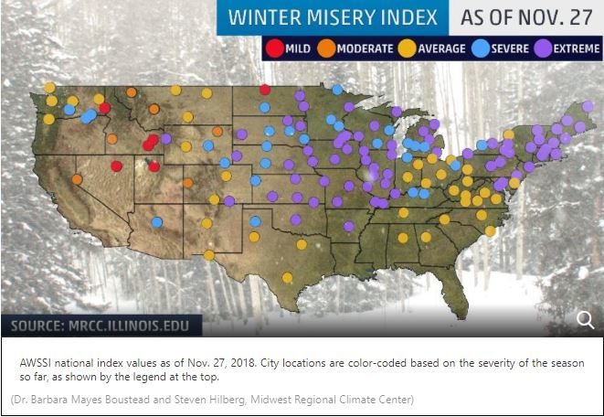
US winter misery index
© The Weather Channel (screen capture)
It's already one of the coldest and snowiest starts to the winter season in parts of the Northeast, Midwest and Plains, and we haven't finished November yet.

According to the Accumulated Winter Season Severity Index (AWSSI) from the Midwest Regional Climate Center, 74 cities from New England to the Plains and Rockies have seen an extreme season-to-date of cold and snow as of Nov. 27.

This index takes into account the "intensity and persistence of cold weather, the frequency and amount of snow and the amount and persistence of snow on the ground," the Midwest Regional Climate Center says. Wind and mixed precipitation, such as freezing rain, are not a part of the index.

The index uses five categories - mild, moderate, average, severe and extreme - to rate the severity of winter weather in cities across the U.S.

For any given location, the start date of the winter season is defined as when the first measurable snowfall (at least 0.1 inches) occurs or when the first high temperature of 32 degrees or lower is recorded. The start date is Dec. 1 for any location that does not see either of those happen before that date.

"The spread among the categories is very narrow this early in the season," said Dr. Barbara Mayes Boustead, a co-creator of the index and an instructor at the National Weather Service's Warning Decision Training Division in Norman, Oklahoma.


Comment: Snowmageddon: 6,000 flights grounded or delayed in US as Thanksgiving storm rages on


Ice Cube

Adapt 2030 Ice Age Report: Sun dimming the geoengineering excuse why Earth is cooling

multiple waterspouts
© Donwahah Khiaddech
More unusual climate extremes across the planet from three feet of rain in Saudi Arabia to snow in the Canary Islands, quadruple waterspouts in Thailand, EF4 waterspouts in Italy, record snow France and Russia, but winter beauty in Romania with ice flowers. Be scared as sea level rises will make you leave the coast by 2300.


Sources

Smiley

Primary cause of global warming finally discovered

Cause of Global Warming
© Babylon Bee
Grants Pass, OR - Scientists have finally discovered the primary cause of global warming: local kid Oliver Paulson, who left the front door wide open dozens of times while the heater was on this past weekend.

Every time the boy runs inside from playing, he leaves the front door open, and it looks like we're all going to pay the price from his carelessness.