Extreme Temperatures
S


Igloo

100 year snow records broken across the Southeastern U.S. on October 31st and November 01st

It was the earliest and heaviest snow in several places since records have been kept dating as far back as 1880.
Record Snow
© wattsupwiththat.com
100 Year Snow Records broken across the South Eastern US on October 31st and November 01st. It was the earliest and heaviest snow in several places since records have been kept dating as far back as 1880.

Reduced sunspot count shows Solar hibernation is occurring along with the Pacific Decadal Oscillation (PDO) showing a cooling Pacific Ocean and the Atlantic Multi-Decadal Oscillation (AMO) Atlantic Ocean temperature is predicted to fall by 2020, which screams of cooling events to take place globally.

Snowflake Cold

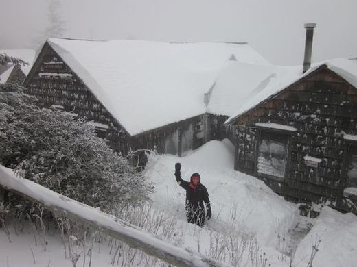
Record snowfall prompts road closures and evacuations from Great Smoky Mountains National Park

Image
© Highonleconte.comLeConte Lodge crew member Jeanie Lawley in one of the snow trenches outside their dining room
Rangers in the Great Smoky Mountains National Park closed all roads due to slick conditions from snow and ice and concerns about downed trees from high winds.

The list of road closures includes U.S. Highway 441/Newfound Gap Road, Little River Road, Laurel Creek Road and Cades Cove Loop Road.

The Sugarlands and Oconaluftee visitors centers are open.

Rangers also began working to evacuate campers at the Elkmont and Cades Cove campgrounds due to fallen trees and concerns about safety. All campers must leave Elkmont. Campers in tents must leave Cades Cove. RV campers will be allowed to stay at this time.

Snowflake

Winter is coming: Earliest snowfall in recorded history falls in Columbia, SC

snow columbia south carolina
© WISTV.com
The snow that fell in the Midlands on Saturday morning is the earliest in recorded history.

Some areas reported 2-3 inches of the white stuff. The snow stayed mostly to the north and to the west of Columbia.

At this point, most roadways are not cold enough to cause any icing or accumulations, however, you are urged to be cautious in areas where frozen precipitation has fallen. Be especially aware when driving over bridges as those will freeze first.

Igloo

Weekend storm to bring first snowfall to New England, Great Lakes, Appalachians

Image
© Weather.com
Winter storm warnings and winter weather advisories are posted for parts of the Appalachians and snow advisories are in effect in the Great Lakes as the season's first snow targets those areas from Halloween into the weekend.

As of Friday morning up to 8 inches of snow fell in Winchester, Wisconsin and near Three Lakes, Michigan. Wind gusts up to 60 mph have also been reported in parts of Michigan.

Snow Timing

Given the expected intensity of a southward plunge of the jet stream and the magnitude and depth of cold air pulled with it, we're not simply talking about chilly rain showers, but also accumulating snow for some as well as the first flakes of the season for others.

- Friday: The cold front plunges through the Great Lakes early, then through the Ohio Valley and Appalachians. Rain will mix with, or changeover to wet snow in parts of Michigan and Wisconsin and spread to the Ohio Valley and Appalachians later in the day into the night. Bands of lake-effect rain or snow will also set up.

- Saturday: Additional snow will fall over the Appalachians and parts of the piedmont from east Tennessee and western North Carolina (possibly Upstate South Carolina) north to at least West Virginia. Some wet snow may also linger in parts of eastern Lower Michigan, Ohio, western Pennsylvania, western New York. Snow may develop later in parts of northern New England.

- Sunday: Snow, possibly heavy, in parts of northern New England and gusty winds are expected as well.

Comment: To learn more about what is behind the erratic weather and climate change, listen to the SOTT Talk radio shows below:

SOTT Talk Radio: Climate Change, Food Shortages and the Future
SOTT Talk Radio show #70: Earth changes in an electric universe: Is climate change really man-made?


Ice Cube

US: Cold temperatures rush into East, shock parts of South

Image
The coldest air since April will blast into the Eastern states and will shock parts of the South this weekend.

In many areas, the cold air will be pushed along and enhanced by gusty winds.

The winds will be generated by a winterlike storm swinging off the mid-Atlantic coast and possibly taking a curved path back toward New England.

Gusts ranging between 35 and 50 mph will sweep from the southern Appalachians to the Carolina, Georgia and northeastern Florida coasts, initially. Next, the swath of strong winds will roll across the mid-Atlantic and New England later this weekend.
Image
The combination of plunging temperatures, winds and other conditions will produce shockingly low AccuWeather RealFeel® Temperatures. Levels will dip into the teens over the Appalachians and New England to the 20s over the interior South and along the mid-Atlantic coasts and to the lower 30s in part of Florida.

Snowflake

Record snowfall for Halloween in Chicago

Image
© Sascha Hedjbeli
Windy conditions and snow have caused hundreds of flight cancellations and delays Friday at O'Hare International Airport, officials said.

As of 11 a.m., more than 300 flights were reported canceled and delays of up to an hour were reported at O'Hare, according to the Chicago Department of Aviation.

According to to FlightStats, an online site that monitors air traffic, 304 flights in and out of O"Hare had been canceled.

Halloween started with a record snowfall for many Chicago-area residents. As of 8 a.m. Friday, O'Hare and Chicago Rockford Airport had one-tenth of an inch of snow, the most snow on record for Oct. 31 for the city of Chicago, according to the National Weather Service.

Scattered snow showers are expected throughout Friday morning, said Gino Izzi, a meteorologist with the National Weather Service.

"It's just scattered showers, but it could come down decently, briefly," Izzi said. "I doubt anything will stick though."

Precipitation should end later Friday morning for the Chicago metropolitan area, but a high wind warning will be in effect until 6 p.m., with wind gusts expected to reach 60 mph near the lake.
Ice Cube

North Pole becomes covered in ice in 8 days - video

Image
North Pole
South Pole still at record levels

........................................................................................................................

8 days ago, dutchsinse put out a video showing that the North Pole Ice pack was growing rather rapidly.


After doing some mileage computations on the spread of the ice, dutchsinse made the statement that the North Pole would be covered in a couple weeks (or less).

Thanks to Marcus Adrian for this video

Cloud Precipitation

Severe hailstorm causes havoc in Australian wine country - up to 30% vineyard losses

Image
Vineyards in the south of Western Australia could see yield losses of up to 30 per cent after they were hit by damaging hail storms this week.

Severe thunderstorms struck the South West and Great Southern regions on Wednesday evening.

Wineries in Frankland and Pemberton were hardest hit, with reports of hail completely stripping vines of new season growth.

Ferngrove Wine Group was one of the wineries that fell victim to the hail. Ferngrove senior winemaker Kim Horton said that the storm completely damaged some vines, but some were left unscathed.

Snowflake Cold

"Winter" begins in Greece with rain storms, early snow and sharp temperature drop

Image
huh? where is the Acropolis?
Winter arrived in Greece with heavy rain, strong winds, early snow in the mountains and sharp temperature drop. Sudden rain storms turned streets into rivers. the island of Zakynthos (Zante) was hit by a mini-tornado that uprooted trees, swept away stables roofs and destroyed balconies.

Image
Snow felt not only in some mountain areas in the north of the country (Samarina, Kastoria) but also in Mount Parnassus in Central Greece.

Snowflake Cold

Heavy snowfall in Bulgaria blocks roads, stops trains and leaves 50 villages without electricity

Image
Gabrovo and Sevlievo declare emergency because of extremely severe winter conditions. More than fifty villages have no electricity. All roads and passes in the region are blocked.

The main roads in the country are closed, trains are stopped, and thousands of subscribers are without electricity .

Heavy snow did not stop for ten hours, along with hurricane winds and freezing temperatures.

40 people, including 20 children, were stranded for four hours at the train station after trains stopped moving in the region.