Extreme Temperatures
S


Snowflake

Snow 5 feet deep on the Argentina-Chile border

Image
"At the other side of our cooling globe, snowfall reached highs of 45 cm (18 inches) to 150 cm (5 ft) in the Argentina-Chile border region (Paso Pehuenche)," says reader Argiris Diamantis. "In some areas there was five feet of snow."

7 May 2014 - "Workers operated with orderly withdrawal, according to the weather forecast. The snowy accumulation in the first round was 45 cm, while in the second sector a meter and a half high of snow was recorded. The passage is cleared form the Argentine side, and stood waiting for the clearance from the Chilean side."

Thanks to Argiris Diamantis for this link

Ice Cube

Major Arctic sea ice story lurking, but is anyone looking?

There is a huge event being forecasted this year by the CFSV2, and I don't know if anyone else is mentioning this. For the first time in over a decade, the Arctic sea ice anomaly in the summer is forecast to be near or above normal for a time! While it has approached the normals at the end of the winter season a couple of times because of new ice growth, this signals something completely different - that multiyear growth means business - and it shows the theory on the Atlantic Multidecadal Oscillation (AMO) is likely to be on target. Once it flips, this red herring of climate panic will be gone. Global and Southern Hemisphere anomalies are already unmentionable since the former is well above normal and the latter is routinely busting daily records.

Image
The biggest minimum anomalies are in the summer since this flipped, and the only peaks came very close to the height of winters once this melting was underway.

Now look at what the CFSV2 forecasted for 2012.

Snowflake

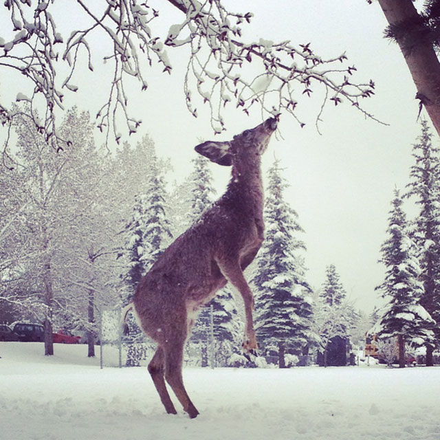
Cold stagnant weather pattern turns Calgary into a winter wonderland in May

Image
© Alexandra BakerFive deer were wandering around 90th - Glenmore Landing and Pump Hill area on a snowy May 3. This one put in the extra effort for a snack.
Calgarians traded in their slickers and umbrellas for parkas and mittens after rain turned to snow overnight, transforming the city into a winter wonderland Saturday morning.

Heather Smith, a meteorologist with the weather agency, said the snow was being generated by a strong low pressure system in the pacific pushing moisture into the province combined with an arctic high ushering in cold air.

"It's a stagnant weather pattern and not much is changing," Smith said on Saturday. "It will snow on and off for the next few days."

The spring snowstorm forced city officials to cancel the 47th annual pathway and river cleanup event, which had been scheduled for Sunday morning. Approximately 2,900 volunteers had been set to pick up thousands of garbage along 200 kilometres of pathway, the river's edge, and in city parks.

The event has been moved to May 25th.


Ice Cube

Slow ice melt on the Great Lakes could lead to chilly summer

Image
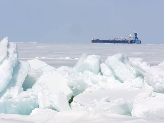
© Photo: Eric Seals, Detroit Free PressA freighter makes its way along after passing under the Mackinac Bridge on April 15. The shipping season is off to a very slow start because of unseasonably heavy ice.
The Winter of 2013-14 demands that it be remembered.

A relatively cool spring will give way to a colder-than-usual summer locally, all because of the continuing impacts of the intensely frigid, snowy winter, scientists said. And at least one Great Lakes ice researcher thinks that the domino effect could continue into a chilly fall and an early start to next winter - and beyond.

The reason is the unusually late ice cover that remains on the Great Lakes. Heading into May, the Great Lakes combined remain 26% ice-covered, with Lake Superior still more than half-blanketed in ice. By comparison, at this time last spring the lakes were less than 2% covered with ice.

The remaining levels of ice cover are amazing, said Jia Wang, an ice climatologist at the National Oceanic and Atmospheric Administration's Great Lakes Environmental Research Laboratory in Ann Arbor.

"This prolonged winter will affect summer temperatures. This summer will be cold, and then a cooler fall," he said.

In addition to wreaking havoc on the Great Lakes shipping industry and impacting fish and other aquatic species, the miles of ice cover serve as a vast, white reflector.

Binoculars

Rare nonmigratory Arctic bird seen on Point Peninsula, New York

Image
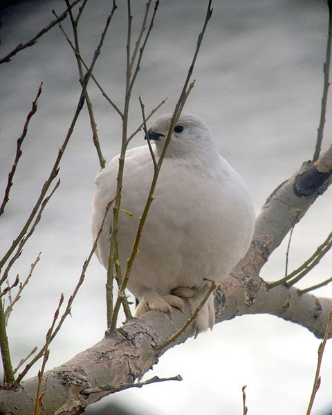
© Jeff Bolsinger.A Willow Ptarmigan along eastern Lake Ontario. The sighting this week is a first for New York State.
Carloads of birders from across the region have visited the shore of Lake Ontario, near Watertown, over the last few days hoping to glimpse a rare avian visitor from the Arctic tundra.

Late last week, Eugene Nichols was birding near Point Peninsula and found an all white bird that didn't belong in northern New York. Nichols contacted Jeff Bolsinger, a bird biologist at Fort Drum, who confirmed that it's a Willow Ptarmigan. Bolsinger says the bird normally lives only in northern Canada and Alaska. He says the sighting this week is the first documented sighting of a Willow Ptarmigan in New York State, and the second recorded in the lower 48 states in a century.

Bolsinger told Todd Moe he's not sure how the bird ended up this far south, but it's become an instant celebrity in the birding community.


Binoculars

Rare Arctic Ross's gull found in Torbay, Newfoundland

Image
© Bruce MactavishRoss's Gull at Torbay, Avalon Peninsula, Newfoundland
Birdwatchers in Torbay had a treat this week when a rare Ross's Gull was spotted. Bird expert Bill Montevecchi says the seagull is recognizable for its pink colour, making it perhaps the flashiest gull on the water. Montevecchi says the bird, along with many European golden plovers, have made it here because they have been blown off-course by strong northerly and northeasterly winds.

He says birders looking for rarities are watching the weather. He says these winds are the most interesting because that's how European birds wind up here.

Montevecchi says for birds blown off course, Newfoundland is a welcome rest for them before they get back on their way.

He says a lot of the birds probably don't make it, and perish in the ocean. But for the ones who do, they get a chance to refuel. He says they most likely do get back on track after they rest.


Ice Cube

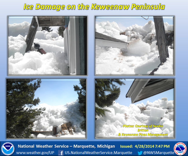
Wind pushes 8-foot high ice slab ashore on Keweenaw Peninsula, Lake Superior damaging property

Image
© National Weather ServiceStrong winds on Lake Superior pushed a mass of ice against homes and outhouses in the Keweenaw Peninsula along Big Traverse Bay on Monday, April 28.
Strong winds on Lake Superior this week slowly edged an 8-foot mass of ice against outhouses and homes on the Keweenaw Peninsula, an event that meteorologists say is rare for the area.

Dave Petrovich, a meteorologist with the National Weather Service in Negaunee Township, said outbuildings and other structures along Big Traverse Bay were damaged Monday, April 28, when easterly winds stronger than 27 mph pushed the ice mass to shore.

"It was moving this mass of ice westward, not very fast mind you, but inexorably when it got to the eastern shores," Petrovich said. "The ice itself was not like the thick ice skating rink ice that you would imagine on a lake."

Petrovich said the slow and steady ice formation called ice shelving isn't unheard of - there have been other recent formations in Gladstone that moved into a city park, he said - but it is rare for Lake Superior, which was still about over 60 percent covered when the ice mass formed.

"They happen quite regularly when the conditions are like this," Petrovich said. "In recent history we've not had as much ice."

Ice Cube

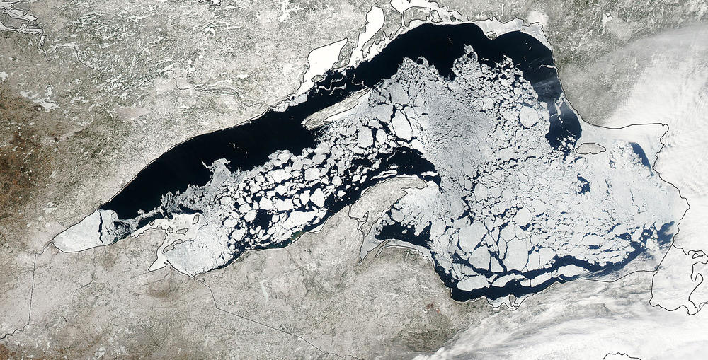
Will Lake Superior still be ice-covered in June?

Image
© NASA photoA photo of Lake Superior taken on April 20 with NASA’s Aqua satellite shows an ice-coverage level of about 67 percent.
Duluth's corner of Lake Superior on Wednesday was a curio cabinet of strange times on the lake this spring.

Seven lakers bore through gloppy ice and passed under the Aerial Lift Bridge during the noon hour. It was a sign of how slow-going things have been on the lake because of lingering ice and, earlier this week, gale warnings. Strong wind blew in ice from the eastern part of the lake, and areas off shorelines 15 miles north and south of Duluth were cluttered with a soup of ice, tree trunks and other detritus.

"It's fun," said a hustling Beth Duncan at the Lake Superior Maritime Visitors Center, near the lift bridge in Canal Park. The U.S. Army Corps of Engineers park ranger was on the loudspeakers inside and out, calling out facts about each ship for the few dozen boat watchers braving a pelting rain and the handful inside the museum. The Canadian ship Thunder Bay had just passed through - the third ship in 15 minutes - and she was gathering information on four more ships lined up in the distance, painted with mist and fog.

She said it was unique that seven ships in succession slipped into Duluth. It was more like a Tall Ships festival than everyday shipping business.

Snowflake Cold

Unexpected snowfall kills 2,000 hectares of crops in Adjara, Georgia

Image
Most of the perennial crops grown on 2000 hectares (5,140 acres) died due to snowfall, said correspondent Levan Bolkvadze.

"As a result of an unexpected snowfall, which hit the mountainous regions of Adjara on April 22 affected 200 hectares of vineyards, 650 hectares of walnut (of which 120 grow large varieties), as well as 600 hectares and 650 hectares of persimmon stone fruits (tkemali,)" said Bolkvadze.

According to Bolkvadze, 70 percent of those vineyards under the snow will not yield this year, walnuts will give only 20 % of the expected yield, and the persimmon do not even ripen - the trees are just green leaves.
Adjara is an autonomous republic in the southwestern corner of Georgia, bordered by Turkey to the south and the eastern end of the Black Sea.
----------------------------------------------------------------------------------------------------------------------------------------------

The hectare is defined as 10,000 square metres (100 m by 100 m). An acre is about 0.4047 hectare and one hectare contains about 2.47 acres.
Thanks to Argiris Diamantis for this link.

Ice Cube

Antarctic sea ice extent 50% above previous record

Image
© NASA/GRACE team/DLR/Ben Holt Sr.
Have you read about this startling news in the mainstream media?

If Antarctic sea ice had shrunk by even a minuscule .000001 percent, the media would be all over it.

Why is Antarctic sea ice growing at such a rapid rate?

Image
"Antarctic sea ice has been growing rapidly over the last 30 years, because Antarctica is getting colder," says Steven Goddard website

Antarctic_Sea_Ice-28Apr2014

April 28 Antarctic sea ice area anomaly 50% above the previous record

Thanks to George Martinez for this link.

Source: arctic.atmos.uiuc.edu