Extreme Temperatures
S


Snowflake

162 inches of snow forecast for Mt. Rainier this weekend; 70 inches for Mt. Baker

Image
© NOAA
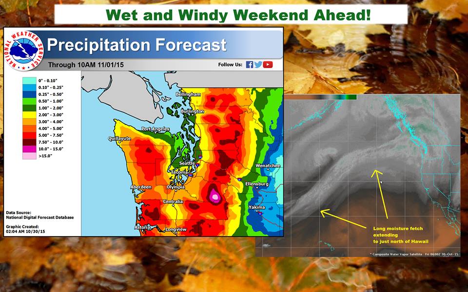
Up to 162″ of snow (13.5-feet) is currently forecast to fall on 14,411-foot Mt. Rainer in Washington state in the next 3 days. That huge snowfall total is due to an atmospheric river that will be "slamming" into Washington this weekend.
THE PRECIPITATION BULLSEYE OVER MOUNT RAINIER IS MORE THAN 20 INCHES IN 48 HOURS IN THE WETTEST MESOSCALE MODELS. - NOAA Seattle, WA today
Even 10,000-foot Mt. Baker is forecast to get 70″ of snow in the next 3 days... This is gonna be a crazy weekend in Washington state.

Snow levels will start high but will drop to as low as 4,000-feet by Sunday.
SNOW LEVELS WILL DROP TO AROUND 4000 FEET ON SUNDAY WITH A FEW INCHES OF SNOW POSSIBLE IN THE MOUNTAINS. - NOAA Seattle, WA
Image
See that white spot southeast of Olympia? That’s Rainier… Over 15″ of liquid precip… crazy.
Some models are even showing up to 20-inches of liquid precipitation (which would translate to about 20-feet of snow) in only 48 hours on Sunday.
"A pair of frontal systems with a significant tap of Pacific moisture will move through western Washington this weekend. They will bring heavy rain at times with the mountains receiving 4 to 8 inches of precipitation with locally higher amounts possible near Mount Rainier. Snow levels will remain high through Saturday before falling on Sunday as a cool upper level trough digs into the region. In addition to the precipitation, windy conditions at times are expected for much of the region." - NOAA Seattle, WA

Image
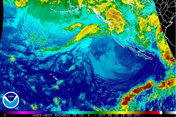
© NOAAImage of the atmospheric river hitting Washington today.

Ice Cube

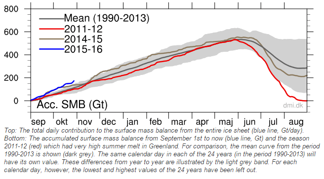
Greenland wiping away all records for ice gain this year

Image
Greenland is blowing away all records for ice gain this year. They have gained almost 200 billion tons of snow and ice over the past two months, which is more than 50% above normal. The surface of the ice gained more than 200 billion tons during the previous 12 months.

Image

Snowflake

Heavy snowfall hits large swath of north China

Image
Heavy snow hits large swath of north China
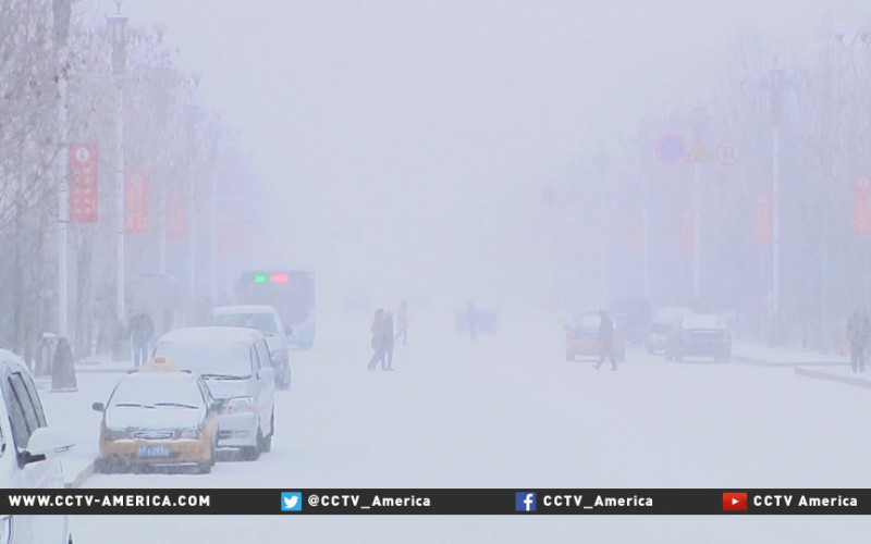
Heavy snow has blanketed a large swath of north China on Monday, Oct 26th, disturbing traffic but bringing beautiful winter scenery.

A snowstorm hit Mohe, China's northernmost county in Heilongjiang Province, from early morning on Monday.

The depth of snow reached 8 centimeters (3.14 inches) by 17:00 and the heavy snow brought the visibility down to less than 100 meters (328 feet) as well. Vehicles have to slow down on snow-covered roads, while the local sanitation department dispatched snowplows to clear up the roads.


Snowflake

Record snowfall for Chabarovsk in Siberia

Image
Record snowfall paralyzed the main highway in Chabarovsk, in far eastern Siberia.

By ten o'clock in the morning it was practically impossible to get to the airport, or to drive on Krasnorechenskoe in the industrial area.

Motorists admitted that they were not prepared for disaster, and did not have time to change summer tires for winter.

Ice has led to a lot of minor accidents in all areas of the regional center, said the driver of one of the Chabarovsk taxis.

Recall snowfall hit the city streets in the morning on October 24.


Thanks to Argiris Diamantis for this link

Snowflake

Tourists stranded following heavy snowfall in Naran Valley, Pakistan

Image
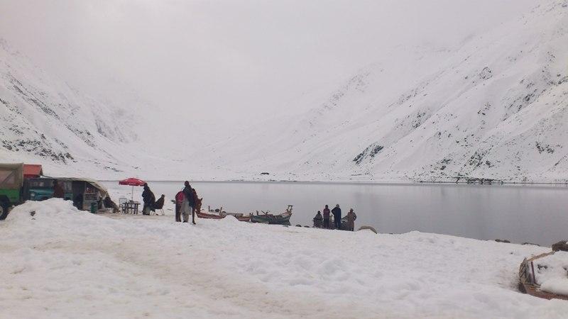
Several tourists have been stranded in Naran Valley after heavy snowfall cut off the area from rest of the country on Sunday.

Women and children are among the tourists from across Pakistan and facing difficulties due to running out of supplies amidst continuous rain and snowfall.


Taking advantage of the situation, several hotel owners have also raised prices of food and accommodations.

Matiullah Khan, president of a local hotels association, however claimed that accommodations were being provided for free to the stranded tourists.

The fresh spell of snowfall had started yesterday afternoon, also trapping several vehicles on the roads.

Snowflake

Unseasonal snowfall brings winter in October to parts of Kashmir, India

Image
Met department officials say they have no record of heavy snowfall in the Valley during the month of October
Even though it's the middle of autumn, in parts of Kashmir it seems like winter. Cold temperatures have brought unseasonal snowfall at higher reaches of the valley.

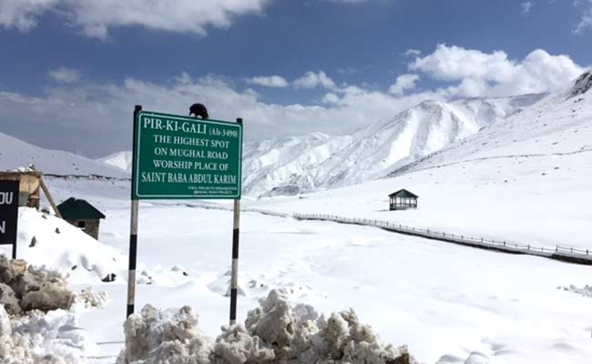
For last two days Mughal Road that connects Kashmir valley with Pirpanjal region has remained closed and hundreds of trucks were stranded along the key passage.

At an altitude of 11,000 feet, Peer Ki Gali, the highest spot on Mughal Road has seen about two feet of snowfall in last 48 hours. But as the weather improved today and sun came out, officials increased their efforts to clear the road.

"Snow clearance machines are at work since yesterday and road will be fully functional today. We have already cleared over 500 trucks yesterday evening," said Nisar Ahmad, an engineer at Mughal Road.

Comment: See also: Heaviest blizzard in at least 10 years hits Omsk, Russia... and it's still October


Binoculars

Birds from the Arctic arrive early at Point Calimere, India

Image
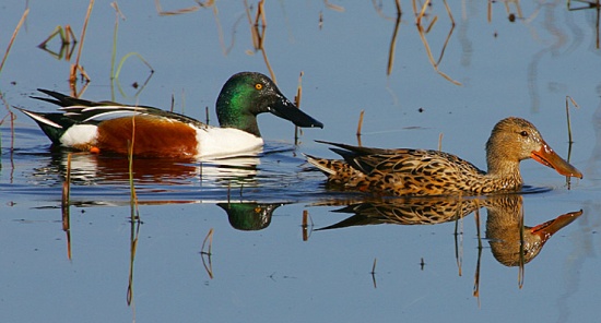
Northern Shoveler
With the beginning of migratory season, thousands of birds, mostly from the Arctic region, have started arriving at the Point Calimere birds sanctuary here. Though the season is yet to peak, ornithologists fear there might be a significant drop in numbers and variety this year as even the common migratory wader species are scarce now. They attribute the phenomenon partially to climate change.

Headed by the Greater Flamingos, the flock of birds, including numerous near-threatened species, is flying into the internationally recognised 'Important Bird Area', while some of them use the sanctuary as a stopover before proceeding elsewhere.

Birds migrate when the weather in their breeding areas turns colder and beyond freezing point and food becomes scarce.

This migratory season some species have arrived early this season. Ducks, which normally arrive by October-end, are already here three weeks in advance. Northern Shoveller, a long-distance migratory duck species, which breed in the Arctic region, has come in several hundreds. Many species that are globally near-threatened, are now seen in significant numbers.

Comment: See also these similar recent reports from Europe and North America -

Migrating birds arrive early at nature reserve in Lincolnshire, UK - so are we in for an extra cold winter?

Britain faces longest winter in 50 years after earliest ever arrival of Siberian swan

30 Arctic Snowy owls arrive in Wisconsin; earliest date ever reported and record numbers


Binoculars

Migrating birds arrive early at nature reserve in Lincolnshire, UK - so are we in for an extra cold winter?

Image
The Redwing bird has been spotted early at RSPB Frampton Marsh nature reserve.
Species of migratory birds have arrived at a Lincolnshire nature reserve earlier than expected this year.

But is this a sign that we are in for an extra cold and long winter?

Chris Andrews, the visitor services officer at RSPB Frampton Marsh, said that the site had seen several species of migratory birds arriving earlier than expected.

He said: "We are seeing some migratory birds arriving earlier than usual - such as the Wigeon duck which comes from Scandanavia and the Baltics.


"They would be just starting to dribble in by now but we've got a couple of thousand here already.

"We've got birds like the Redwing and the Fieldfare that have turned up early as well and we've also seen the Whooper swan too."

Snowflake

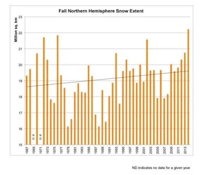
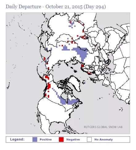
Autumn snow extent steadily increasing for 50 years; well above normal this year

Autumn snow extent has been steadily increasing for 50 years, due to intrusions of Arctic air going further south. last year had the largest autumn snow extent on record.
Image
© Rutgers University Climate Lab Rutgers University Climate Lab :: Global Snow Lab
Snow cover is well above normal again this year.
Image
© Rutgers University Climate LabRutgers University Climate Lab :: Global Snow Lab

Binoculars

30 Arctic Snowy owls arrive in Wisconsin; earliest date ever reported and record numbers

Image
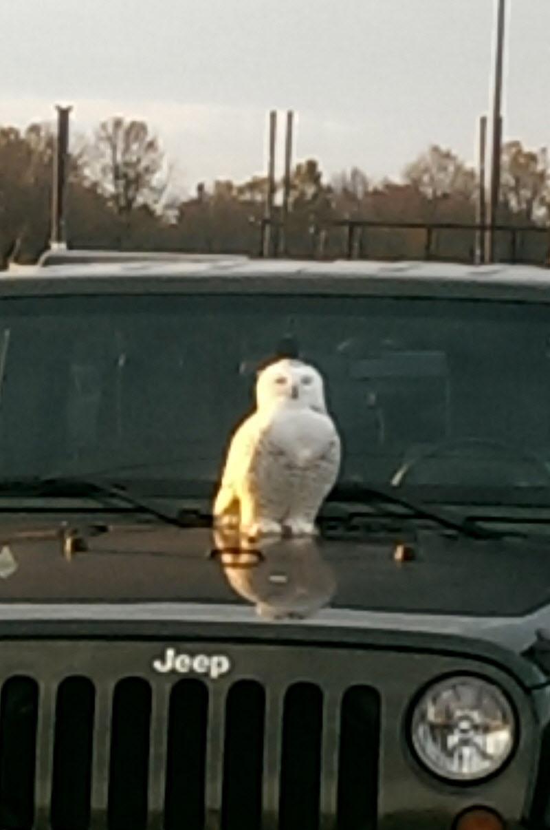
A snowy owl rests on a car in the Kohler Corporation parking lot Tuesday morning.
Snowy owls, the big, white birds that nest in the Arctic and sometimes fly south in the fall and winter, have begun showing up in Wisconsin over the last week, captivating wildlife watchers and raising questions among scientists.

About 30 snowy sightings were reported through Wednesday in Wisconsin, according to Ryan Brady, a wildlife biologist with the Department of Natural Resources who oversees the Wisconsin eBird website.

The reports are earlier in the season and higher in number than any year on record.

"It's unprecedented," said Tom Erdman, curator of the Richter Museum of Natural History at UW-Green Bay who began conducting snowy owl research in Wisconsin in the late 1950s. "It's causing us to ask 'Why?"

The first snowy of the season was sighted Oct. 15 near Ashland in Bayfield County on Lake Superior. The next day one was seen in Crawford County in southwestern Wisconsin. On Tuesday lone snowies were reported in Kohler and Milwaukee.

And on Cat Island in Green Bay earlier this week, six snowies were seen at once, Erdman said.

Comment: There was in addition this exceptionally early arrival date reported from North Dakota on September 28th.

See also: SOTT Exclusive: Snowy owls flee northern latitudes for unprecedented fourth consecutive year - Sign of impending Ice Age?

Britain faces longest winter in 50 years after earliest ever arrival of Siberian swan