Extreme Temperatures
S


Snowflake

95% apple trees, crops ruined by early snow in Lahaul, India

apple damage
The untimely heavy spell of snow has caused a huge loss to apple trees and fruit and vegetable crops in Lahaul-Spiti district, leaving farmers in despair.

"A big chunk of apple trees, broccoli, cauliflowers, iceberg lettuce and potatoes have perished in snow", said Suresh Vidyarthi, a farmer from Udaipur in the lower Pattan valley, the first area to start apple cultivation in Lahaul in the 1990s.

"Due to climate change, we have been facing freak spells of snow round the year", said Amar Singh, another farmer.

According to the preliminary estimate, more than 95 per cent of apple trees and crop have perished in the recent untimely snow, said Ashwani Chaudhary, DC, Lahaul-Spiti.

Snowflake

One foot of fresh early snowfall hits the Alps

snow
Fresh snowfall on high slopes in the Alps on Sunday evening and Monday led to great excitement on social media as ski resorts posted images and video of snow falling.

For the half-dozen ski areas currently open in the Alps it means that for many today is a powder day on October 2nd with up to 30cm (a foot) of fresh snow lying and now a return to blue skies.

The video below is from the Pitztal glacier this morning; the Kaunertal and Hintertux glaciers are also open, as are Saas Fee and Zermatt in Switzerland and Passo Stelvio in Italy.


Comment: Note that this is not the first heavy snowfall for the coming season in the region, there have already been two major snowing events during August: Global cooling: Extreme snowfall in SUMMER hits the Alps with a depth of one foot

Global cooling: Heavy snowfall in summer over the Alps for second weekend in a row - Up to 8 inches in 24 hours


Snowflake

SilverStar, Big White ski resorts in British Columbia, see early snowfall

Snow falling at SilverStar Mountain Resort Sunday, Sept. 30.
© Brieanna Charlebois/Morning StarSnow falling at SilverStar Mountain Resort Sunday, Sept. 30.
While September is ready to give-way to October in the Valley, it seems Mother Nature has decided to skip straight to winter at SilverStar Mountain Resort.

The fluffy white stuff began to fall and leave a thin blanket in the village Sunday, Sept. 30, nearly two months before the Nordic season tentatively starts Nov. 16 and the Alpine season Nov. 22.

Last year, which was a record-breaking year at the resort, saw its first snowfall Sept. 18.

Big White Ski Resort near Kelowna also saw light snow Sunday.


Snowflake Cold

100-year-old September cold record broken, snowy start to October in Saskatoon, Saskatchewan

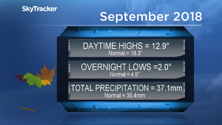
September 2018 was 4 degrees colder than normal with slightly above average precipitation in Saskatoon.
© SkyTracker WeatherSeptember 2018 was 4 degrees colder than normal with slightly above average precipitation in Saskatoon.
Century-old cold record shattered as snow slides in to start October.

Cool and wet September

September 2018 was way colder than normal in Saskatoon with temperatures trending a whopping four degrees cooler than normal overall.

Most of that was on the daytime high side of the scale with the mercury averaging out an impressive 5.4 degrees cooler than seasonal with overnight lows 2.5 degrees below normal.


Snowflake

Southern Saskatchewan hit with snow on first day of October

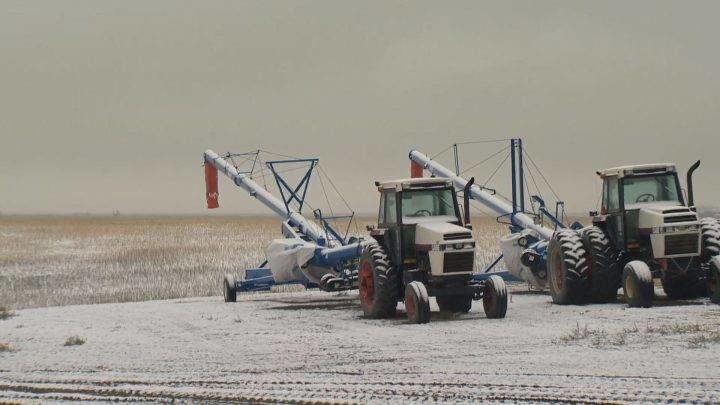
On the first day of October southern Saskatchewan woke up to a white blanket of snow covering the ground.
© Taryn Snell / Global NewsOn the first day of October southern Saskatchewan woke up to a white blanket of snow covering the ground.
On the first day of October southern Saskatchewan woke up to a white blanket of snow covering the ground.

According to Environment Canada, Regina and area have seen periods of light snow that will last throughout the morning but by afternoon we should see a high of eight degrees.

On Tuesday Southern Saskatchewan will see periods of mixed snow and rain throughout the day with a high of three degrees.

"We are looking at another system moving in tonight so that will spread some snow and rain in the south west into the evening and that will be pushing through southern Saskatchewan tomorrow, so a better chance of accumulating snow tomorrow maybe looking at a few centimetres especially in areas just to the north of Regina," said Environment Canada Meteorologist Mark Melsness.

Tornado1

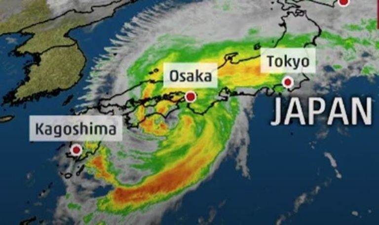
Japan hit by unseasonal high temperatures after Typhoon Trami leaves four dead, hundreds injured & travel chaos

Typhoon Trami: The storm has blasted across Japan
© THE WEATHER CHANNELTyphoon Trami: The storm has blasted across Japan
Tokyo woke up to unseasonal heat and bright cloudless skies on Monday (Oct 1), hours after the ferocious Typhoon Trami caused widespread power outages, cancelled flights and shut down train services as it churned towards the Pacific Ocean.

Commuters in central Tokyo experienced massive transport snarls during the morning rush hour - with many unable to get to work on time - as rail operators delayed the start of train services to clear fallen trees and other debris.

One of the services was the Keio Line, after a train hit a collapsed wall in Setagaya ward at about 4.45am, halting services for over four hours. No one was injured.

Across the country, the season's 24th typhoon left at least four people dead, one missing and more than 200 injured, according to a tally by public broadcaster NHK as at 9pm (8pm in Singapore).

The storm first slammed into the south-western Okinawa chain of islands on Saturday, before moving north-east and making landfall in Wakayama, south of Osaka, on Sunday. It then traversed north-east across the main island of Honshu.

At its peak, the typhoon packed gusts of 216kmh, the Japan Meteorological Agency said. Though it gradually lost strength after making landfall, the western Tokyo suburb of Hachioji still recorded winds of up to 164kmh.
Ice Cube

Adapt 2030 Ice Age Report: Earth's thermosphere record cold & auroras with no CME

The TIMED satellite monitoring the temperature of the upper atmosphere
NASA coming out stating that Earth's Thermosphere is entering record territory and even mentions "Solar Minimum Cold" that's a huge change from warming, warming, warming. I feel the are covering themselves as it cools and people begin to ask questions. For example like how there was no geomagnetic storm and Earth had immense auroras over Alaska, how is that possible unless the magnetosphere is in decline.


Comment: See also:


Ice Cube

Rethinking the mystery of stratospheric cooling

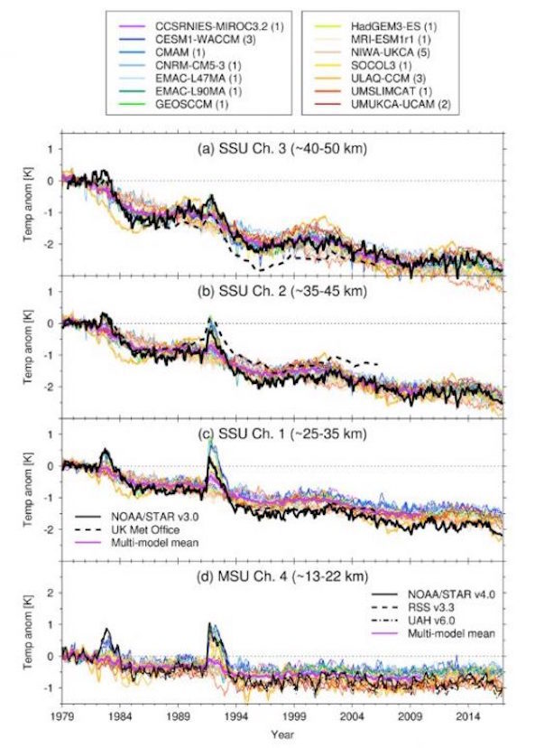
This paper claims that stratospheric cooling is the work of "greenhouse gases". Saying: "An extended satellite temperature record and the chemistry‐climate models show weaker global stratospheric cooling over 1998-2016 compared to 1979-1997."
Stratospheric Cooling
Figure 1 from the paper. Time series of global monthly mean temperature anomalies (K) for the period 1979–2016 for the data sets andaltitude ranges stated in thefigure. Anomalies are shown relative to a baseline of 1979–1981. The number of individualensemble members plotted for each model is shown in the legend. The multimodel mean is shown in thick purple.Note that only the CESM1(WACCM), GEOSCCM, ULAQ-CCM, and UMUKCA-UCAM models include the radiative effectsof volcanic aerosols over the hindcast period in the refC2 experiment. Note the UK Met Office SSU data set is shown as6-month averages. (a) SSU channel 3 (~40–50 km). (b) SSU channel 2 (~35–45 km). (c) SSU channel 1 (~25–35 km). (d) MSUchannel 4 (~13–22 km). SSU = Stratospheric Sounding Unit.

Comment: See also: Temperatures have dropped to -91°C (-131,8°F) in the stratosphere!


Attention

Adapt 2030 Ice Age Report: Indonesian tsunami - Record snow - More Grand Solar Minimum signs?

A gigantic tsunami has crashed into the Indonesian coast

With the Indonesian 7.7 earthquake and tsunami, at the same time Krakatou awoke with over 50 eruptions in the W. Java island area.

All time coldest days in Germany and Netherlands, snowiest September in Alberta and massive frost damage to Australian crops in spring.

Do you think the intensifying Grand Solar Minimum is the cause of the changes we are seeing?


Sources

Snowflake

Snow hampers harvests in Saskatchewan and Alberta

Fields across much of Alberta have been hit hard by both snow and rain
© Jeffrey Heyden-KayeFields across much of Alberta have been hit hard by both snow and rain
Early signs of winter are keeping some combines idle in Western Canada.

Parts of Alberta received several consecutive days of snow, putting grain harvest on hold.

Alberta farmers harvested 31.3 per cent of their spring wheat crop as of Sept. 18, an Alberta Agriculture report says. That number is well below the five-year average of 55.9 per cent.

Canola producers are also feeling the effects of the early snowfalls.

"The snow is slowing wheat and canola farmers down," Denis Guindon, a director with the Alberta Canola Producers Commission, told Farms.com. "The snow is pushing the wheat down so farmers can't harvest the crop. And there's not much canola being harvested because of the snow and fluctuating temperatures.

Comment: See also: A taste of the future: 'Disbelief' as snow hits and northern Alberta farmers scramble to save crops worth millions