Extreme Temperatures
S


Better Earth

The art of green deception . . .about those record temperatures in Antarctica

antarctica
Warren Blair writes:

On the same day (24 March 2015) in the real Antarctic (not Esperanza on the Trinity Peninsula) Australia's Casey research station had its coldest 24 March day in 18 years (minus 12.7 °C). That wasn't mentioned and neither was any other interesting data like Casey's 2015 March mean maximum temperature was the same as 1990 and lower than 1991, 1992, 2001, 2002, 2006, 2007 and 2009.

Highest Antarctic region temperature was 35 years ago when CO2 was 340ppm (15% less than 2015 levels).

19.8°C was recorded on 30 January 1982 at Signy Research Station located at Borge Bay (near Esperanza Base) .

Highest Antarctic temperature for a Plateau station [>2500 meters] was 28 years ago.

-7.0°C was recorded on 28 December 1989 at an Automatic Weather Station (D-80) located inland from the Adélie Coast.

Highest Antarctic temperature for a continental station (outside the Antarctic Circle) was recorded in 2015.

17.5°C was recorded on 24 March 2015 at the Esperanza Base located on the Trinity Peninsula at Hope Bay (near Signy Research Station).

Better Earth

Scientists link California droughts and floods to distinctive atmospheric waves

wavenumber-5
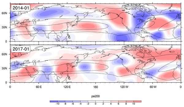
© Haiyan Teng and Grant BranstatorThe high- and low-pressure regions of wavenumber-5 set up in different locations during January 2014, when California was enduring a drought, and January 2017, when it was facing floods. The location of the high and low pressure regions (characterized by anticylonic vs. cyclonic upper-level air flow) can act to either suppress or enhance precipitation and storms. The black curves illustrate the jet streams that trap and focus wavenumber-5.
From NCAR/UCAR:

Boulder, Colo. — The crippling wintertime droughts that struck California from 2013 to 2015, as well as this year's unusually wet California winter, appear to be associated with the same phenomenon: a distinctive wave pattern that emerges in the upper atmosphere and circles the globe.

Scientists at the National Center for Atmospheric Research (NCAR) found in a recent study that the persistent high-pressure ridge off the west coast of North America that blocked storms from coming onshore during the winters of 2013-14 and 2014-15 was associated with the wave pattern, which they call wavenumber-5. Follow-up work showed that wavenumber-5 emerged again this winter but with its high- and low-pressure features in a different position, allowing drenching storms from the Pacific to make landfall.

"This wave pattern is a global dynamic system that sometimes makes droughts or floods in California more likely to occur," said NCAR scientist Haiyan Teng, lead author of the California paper. "As we learn more, this may eventually open a new window to long-term predictability." The finding is part of an emerging body of research into the wave pattern that holds the promise of better understanding seasonal weather patterns in California and elsewhere.

Ice Cube

Unusually large swarm of over 400 icebergs blocking shipping lanes in the North Atlantic

Iceberg
More than 400 icebergs have drifted into the North Atlantic shipping lanes over the past week in an unusually large swarm for this early in the season, forcing vessels to slow to a crawl or take detours of hundreds of kilometres.

Experts are attributing it to uncommonly strong counter-clockwise winds that are drawing the icebergs south, and perhaps also global warming, which is accelerating the process by which chunks of the Greenland ice sheet break off and float away.

As of Monday, there were about 450 icebergs near the Grand Banks of Newfoundland, up from 37 a week earlier, according to the U.S. Coast Guard's International Ice Patrol in New London, Connecticut. Those kinds of numbers are usually not seen until late May or early June. The average for this time of year is about 80.

Snowflake Cold

New Euro-studies support 'global cooling'; record snow hits Canada & ferry trapped in sea ice

record snow in Canada
© YouTube/Adapt 2030 (screen capture)
New Euro-studies Confirm Sun Dominates Earth's Climate a solar sunspot minimum will soon lower earth's temperatures by half a degree C. The long cold minimum is expected to hit about 2040. This comes from The Physical Meteorological Observatory Davos (PMOD), the Swiss Federal Institute of Aquatic Science and Technology (EAWAG), ETH Zurich and the University of Bern. It is now clear that all three temperature surges were caused by the 60-year Pacific Decadal Oscillation, recognized by fisheries experts only in 1996. Now record snowfall in Newfoundland Canada at 120cm with ferry stuck in sea ice plus record ice growth on Greenland.


Comment: The Solar Minimum, Earthquakes and Mini Ice Age - and What to Expect: Interview with John Casey, Author of UPHEAVAL and Dark Winter (VIDEO)


Igloo

Newfoundland blizzard brings record snow

Snow piled up in Gander
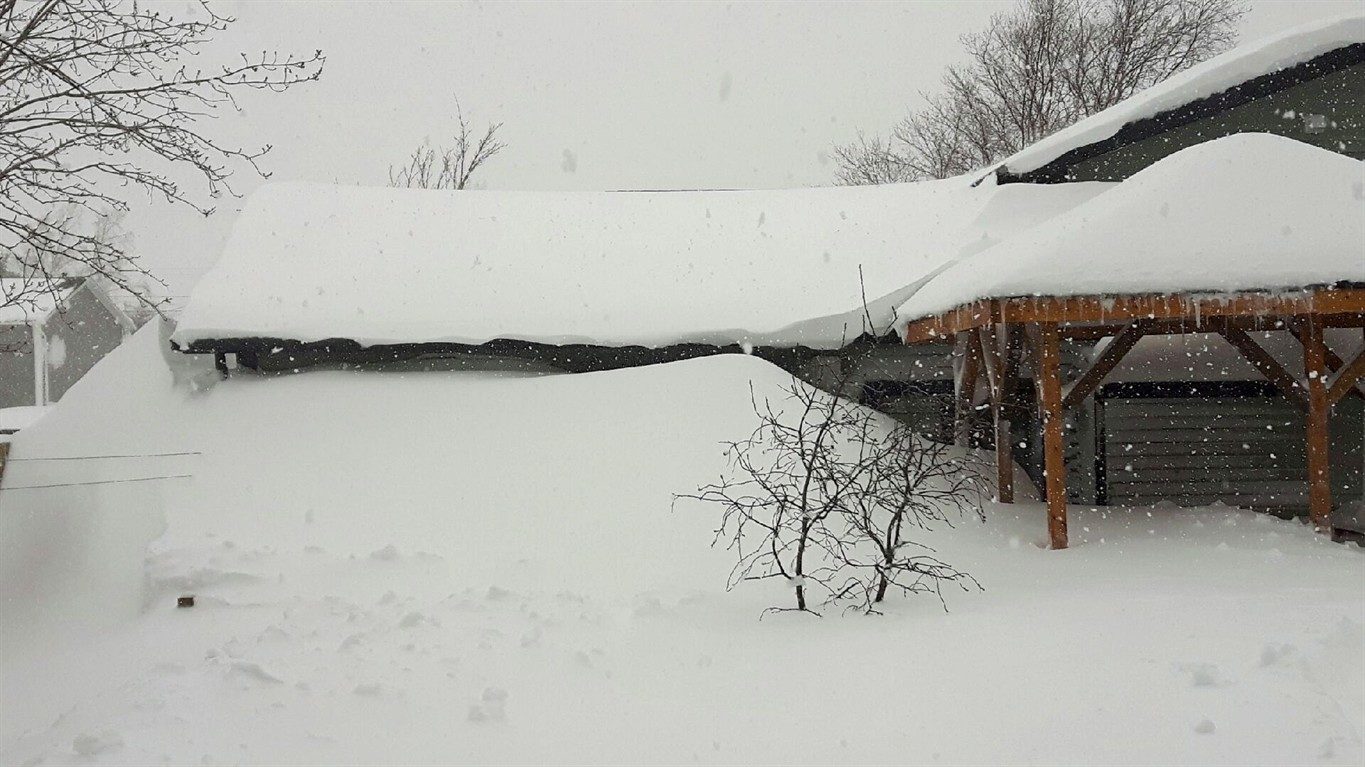
© The Canadian Press/HO-Trudy CarterSnow is piled up in front of house in Gander, N.L. on Monday, April 3, 2017 in a handout photo.
The first day of spring was two weeks ago, but winter is far from over in Newfoundland.

A powerful storm swept across the province this week, and another 75 centimetres of snow is expected by Tuesday evening. Over 97 centimetres was dumped on Gander over the weekend. To put that number in context, Toronto saw 81 centimetres of snow over the entire winter, according to The Weather Network.

Gander broke the snowfall record for March with a total of 200 centimetres, and is on track to break April's previous record of 97 centimetres, VOCM reported.

People trying to get to work have faced some unique challenges.


Comment: Spring storm sweeps across Newfoundland, closing schools and hampering travel


Attention

Whale and dolphins trapped by ice near St. John's, Newfoundland

Trapped whale
© CTV
Residents of a small Newfoundland island tried to carry several dolphins out of thick ice, others watched as a humpback whale was stuck in the icy water.

A hand full of people lifted seven dolphins, one by one, out of the ice, onto a tarp and into a truck to take them to open water.

Wayne Ledwell of the Whale Release and Strandings group says the ice was too thick to navigate with an icebreaker to free the whale that was trapped on Friday. He said they tried everything, but couldn't euthanize it.

Town manager Margie Hopkins said that people tried to reach the whale today, but had no success because of blizzard-like conditions.

A few residents have reported that the whale may have died overnight.

Snowflake

Heavy snows will delay opening of North Cascades Highway, Washington

Looking west from Cutthroat Ridge along SR 20 on March 16, 2017.
© WSDOTLooking west from Cutthroat Ridge along SR 20 on March 16, 2017.
The snowpack giveth, and the snowpack taketh away.

An unusually massive accumulation of snow on the North Cascades Scenic Highway corridor will delay the opening of that vital tourism route to motor traffic until possibly as late as June, the Washington State Department of Transportation (WSDOT) said in a press release last week.

That would make it one of the latest openings in the 45-year history of the North Cascades portion of State Route 20.

The deep snow is good news for local rivers and water supplies this summer, but has made conditions so treacherous for road-clearing crews that the usual starting date for WSDOT work on the highway has been moved from mid-March to April 10.

Snowflake

April Fools' Day snowstorm drops up to 18 inches in New England

Snowfall accumulation map from Mar. 31- Apr. 1, 1997.
© NOAASnowfall accumulation map from Mar. 31- Apr. 1, 1997.
It's April Fools' Day but it's no joke: People across northern New England woke up to a foot of heavy, wet snow on parts of the region Saturday and conducted weekend business as more fell throughout the day.

The storm caused power outages and numerous highway accidents. By mid-afternoon the number of electric customers without power across Vermont, New Hampshire and Maine had dropped to about 8,100 from overnight totals almost three times that number. A winter storm warning in Vermont had expired, but remained in effect for parts of New Hampshire and Maine.

"This is Mother Nature's idea of an April Fools' joke," said meteorologist Eric Schwibs of the National Weather Service in Gray, Maine.

Snowflake

California snowpack is one of biggest ever recorded, now poses flood risk

Snowpack survey in California
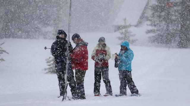
© Justin Sullivan/Getty ImagesFrank Gehrke, center, chief of the California Cooperative Snow Surveys Program for the Department of Water Resources, takes a sample of the Sierra snowpack near Twin Bridges, Calif.
The skies were gray, snow was falling and it was bitterly cold when state snow survey chief Frank Gehrke made his monthly march out to a deep pillow of snow in the Sierra Nevada town of Phillips on Thursday morning.

He plodded across the white mounds, plunged his metallic pole into the powder beneath him, pulled it out and made his proclamation: 94 inches deep.

The 2016-17 winter created one of the largest snowpacks in California's recorded history and it's loaded with enough water to keep reservoirs and rivers swollen for months to come.

"For recreation, there's a lot of pent-up demand for spring touring," Gehrke told reporters and viewers watching on a social media live stream. "Clearly this is going to be a good year for it. People have to be aware that conditions are different and they can't expect the same conditions they had a couple years ago."

With reservoirs and rivers already full from months of rain, the addition of melting snow will likely push water over the banks in some communities and cause flooding, said David Rizzardo, chief of snow survey and water supply forecasting for the state Department of Water Resources.

Comment: Global warming? Sierra Nevada snowpack 185% higher than normal


Snowflake

Record snow buries Anchorage, Alaska

Snow in Anchorage
© AP/Mark ThiessenSnow falls at a bridge crossing Ship Creek in Anchorage, Alaska, Wednesday, March 29, 2017.
It was a late March surprise for residents of Alaska's largest city, the kind that snarls traffic and keeps kids at home for the day.

The National Weather Service said 8.8 inches (22.4 centimeters) of snow fell on Anchorage between 10 p.m. Tuesday and 1:30 p.m. Wednesday. That's a record for March 29 in Anchorage, said meteorologist Rebecca Duell.

The Anchorage School District canceled classes for the day, and the deep snow slowed traffic.

One enterprising person on a bicycle with fat tires was caught by a camera from Anchorage television station KTVA. The cyclist was slowly trudging along a bike path adjacent to a long line of cars waiting to move off a highway exit ramp.

The snowfall wasn't unusual for Anchorage, or for the time of year, Duell said.

The latest snowfall on record of at least one-tenth of an inch is May 22, which occurred in 1964.

Since 1952, the average final snowfall in Anchorage occurs on April 18. The previous high snowfall for March 29 was 3.4 inches (8.6 centimeters) set in 2001.