Extreme Temperatures
S


Snowflake Cold

How well do the dire global warming predictions stand up thirty years on?

James Hansen global warming
James Hansen's warning on climate change.

The short answer, is not all that well.


On June 23, 1988, NASA scientist James E. Hansen testified before the Senate Committee on Energy and Natural Resources, where he expressed his "high degree of confidence" in "a cause-and-effect relationship between the claimed CO2 induced "greenhouse effect and observed warming."

The 30th anniversary of Mr. Hansen's predictions affords an opportunity to see how well his forecasts have turned out.

In an article in the Wall Street Journal today, climatologist Dr Patrick Michaels and meteorologist Dr. Ryan Maue compare Hansen's predictions to actual reality over the past 30 years. Instead of the gloom and doom we heard in 1988, we have an earth that is only moderately warmer, and closer to Hansen's "scenario C", the bottom graph below, which is overlaid with actual global temperature data in red.

Comment:


Snowflake Cold

Australian ski resorts receive up to 28 inches of snow in 3 days, the most since 2000

Staff in Perisher are reporting historic snow depth
© Perisher/FacebookStaff in Perisher are reporting historic snow depth
Australian ski resorts are celebrating the best start to the southern-hemisphere ski season in 18 years, with heavy snowfall and freezing temperatures.

Resorts on the south-eastern coast of the country were hit with blizzard conditions at the start of this week - the storm, which has been nicknamed Stormin' Norman, battered resorts for six days.

Severe weather warnings were issued by the Bureau of Meteorology for the regions of Victoria and New South Wales.

It's an extreme weather pattern than mimics the series of storms that hit the Alps at the start of last winter.

Australia's top five resorts have all benefited from Norman's snowy onslaught. Perisher, arguably the most well-known resort, and part of Vail Resort's Epic Pass, received 71cm of snow in the space of three days and is opening new parts of its ski area daily.


Snowflake

Global cooling: Snow falls in high summer on the Carpathian mountains, Ukraine

snow
Snow has fallen in the mountainous regions of Ivano-Frankivsk region. The thickness of snow cover is 0-13 mm. Ground frosts are expected tomorrow.

Ukrinform learnt this from Head of the Ivano-Frankivsk Regional Center for Hydrometeorology Volodymyr Fryhovych.

"Snow mix with rain has fallen in the Carpathians. Snow cover reaches 13 mm at the mountain peaks. Tomorrow we expect a drop in the temperature in the mountain regions to 1-2 degrees below zero," he said.


Info

Ice Age Farmer Report: Are they really suggesting we..? What will you eat in Grand Solar Minimum

FOOT
Hot foot food
Obligated by synchronicities, Christian delves into the dark agenda behind consumers' shifting perception of 'food' and social engineering involved. As winter slams the Southern Hemisphere, there are echoes of the "freak, unprecedented" failing infrastructure, crops, and loss of life. Crop losses continue globally, and an Italian Meteorologist warns that we may be entering a Mini Ice Age. All of this is, in fact, part of a larger plan - using food scarcity to bring about total control. You can be a part of their plan, or you can make your own plan -- start growing your own food today.


Sources

Snowflake Cold

Adapt 2030 Ice Age Report: What is going on with Antarctic ice loss and global temperatures

antarctic cold
While MSM news outlets planet wide print stories for Antarctic continental ice melting at a 3x faster pace than the last 10 years, they just discredited all of the climate agencies globally like NASA, NOAA, NSIDC & DMI that all showed gains in Antarctic ice on both land and sea. Now global temperatures are at 0.18C when the models all showed we should be at 2.0C and sea levels are lower than predicted. We need to ask questions why we are continually fed conflicting data from the news agencies.


Comment: Some related articles include:


Snowflake Cold

Adapt 2030 Ice Age Report: Antarctica and Australia climate shift - New details emerging

cold
Australian media in damage control to explain Melbourne coldest start in 36 years to winter, record snow and frosts to withing 1500 miles south of the equator toward Cains. Bobby the moderator at OZ Politic has a full thread of 350 pages outside MSM control which shows massive ice gains in sea ice around Antarctica, all the while the MSM screams that we have to act now before the worlds coast lines are washed away by a melting Antarctica. Power grids were stretched to the limits in Australia during the Superfreeze event, but downplaying is the new narrative, and if it doesn't fit, just make a new set of rules. Perhaps we need to look to the Sabians of Harran to understand the cycles.


Sources

Snowflake Cold

Adapt 2030 Ice Age Report: Australia land of sunshine freezes, frost 1500 miles south of the Equator

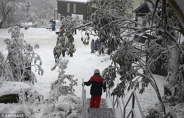
Australia's south east was swept with feverishly cold temperatures
© AAP IMAGEIn the early hours of Sunday morning Australia's south east was swept with feverishly cold temperatures
What could be described as a Superfreeze event engulfed Australia over the weekend, send all but one capital in Darwin below 10C and record snow and cold to other parts with 3/4 of the continent in freeze and frost conditions. Amazingly frost extended to within 1500 miles of the equator. No that is not a misprint, frost just 1500 miles from the equator during this event. Power draw was at all time high and some manufacturers were charged 100x the normal rate and paying up to $14,000 per megawatt. This shows that 100% green energy for a continent is not achievable or sustainable.


Sources

Ice Cube

Study: Arctic sea ice is thicker now than it was in 1955

arctic sea ice volume
Source: Danish Meteorological Institute (DMI), via Kirye
From the "skating on thin ice" department.

According to a new paper published in the Journal of Geophysical Research, the observed mean thickness of the sea ice in the region north of (Arctic) Svalbard was substantially thinner (0.94 m) in 1955 than it has been in recent years (~1.6 m, 2015/2017).

arctic sea ice thinner  2017 1955
Graph Source: Rösel et al., 2018

In 1955, the atmospheric CO2 concentration hovered around 315 ppm, about 90 ppm lower than today's CO2 values.

It is widely assumed that the steep and substantial rise in CO2 concentration since the 1950s is largely responsible for warming the Arctic, and consequently the decline in the Arctic's sea ice volume and extent (IPCC, 2013). This assumption is significantly predicated on the observation that sea ice has undergone precipitous losses since the 1970s, which is when the satellite era began.

Comment: The cooling observed in the Arctic is happening all around the planet:


Snowflake

Global cooling: Snow settles on the mountains of southern Norway just 2 days before midsummer

Sognefjellet
Sognefjellet road to highest pass in Norway. Stock Photo
The mountains of Southern Norway are supposed to be welcoming summer tourists, hikers and cyclists at this time of year, but folks in Sognefjellet, Valdresflyet and Hardangervidda woke up Tuesday to find wet snow that had dusted the landscape. With more snow expected this week, highway officials are urging caution when driving on mountain roads.

All mountain passes remained open but the asphalt can be slick. State broadcaster NRK reported that highway officials at Statens vegvesen aren't demanding a shift to winter tires, but warn that relatively cold temperatures are forecast for the rest of the week. "Drive in accordance with weather conditions," was their standard advice

Snowflake Cold

Australia hit with extreme cold front as snow hits and people are warned of dangerous conditions

Australia's south east was swept with feverishly cold temperatures
© AAP IMAGEIn the early hours of Sunday morning Australia's south east was swept with feverishly cold temperatures
PLUMMETING temperatures have caused freezing conditions and snow across the country - and more severe weather is coming.

A FREEZING cold snap has blanketed parts of the country in fluffy white snow.

Australians have packed on the layers as icy chills continue to blow across southeast Australia thanks to the cold front that's been pushing through the Great Australian Bight since Wednesday.

Severe weather warnings have been issued for parts of New South Wales today as strong gusty winds with cold temperatures and showers are forecast.

The Bureau of Meteorology said a complex low over the Tasman Sea was directing a "vigorous westerly airstream" over NSW ahead of a south to south-westerly change which would move along the coast today.

Damaging winds averaging 60 to 65km/h are predicted with peak gusts of more than 90km/h.

A south to south-westerly wind change is forecast to move along the coast, reaching the Hunter coast by late morning.

Showers may bring damaging wind gusts along the coastal fringe in areas including Gosford, Newcastle, Sydney and Wollongong.

Comment: Some other 'global cooling' reports from around the world in the past two weeks include: June 2018 is already showing signs of Grand Solar Minimum intensification.