Extreme Temperatures
Westbound Kellogg saw delays all morning after a crash near Washington. Northbound 235 was in a similar situation after a crash near 29th N. There were other crashes across the area, but no serious injuries were reported.
The highest snowfall amount recorded in Wichita so far is 2.4-inches. That came from the 21st and Maize area. 1.7-inches of snow was recorded at the Eisenhower airport.
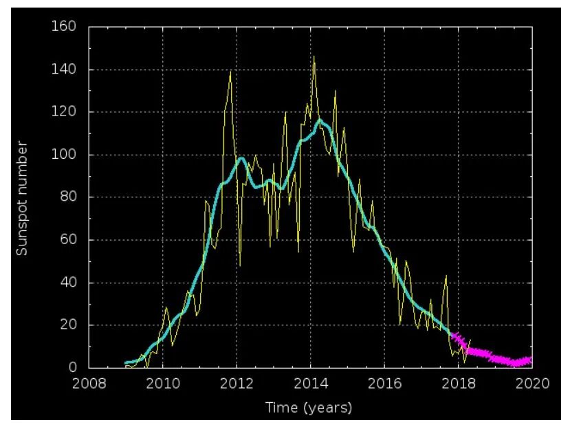
Consider it just the tip of the iceberg: noctilucent clouds (NLCs) over the south pole are AWOL this year, writes Dr. Tony Phillips of spaceweather.com.
NLCs are Earth's highest clouds. Water crystallizing around specks of dust 83 km above Earth's surface creates beautiful electric-blue structures, typically visible from November to February in the southern hemisphere, and May to August in its north counterpart. Their appearance over Antarctica in 2020 is now seriously overdue.
"Normally we see the first NLCs of the southern season around Nov. 21st," says Cora Randall of the University of Colorado's Laboratory for Atmospheric and Space Physics (LASP). "But this year, it's already December and we're still waiting."
Delhi had recorded a mean minimum temperature of 10.2 degrees Celsius in November 1949.
The mean minimum temperature for November was 9.6 degrees Celsius in 1938; nine degrees Celsius in 1931 and 8.9 degrees Celsius in 1930, according to IMD data.
Normally, the mean minimum temperature for the month of November is 12.9 degrees Celsius.
The mean minimum temperature was 15 degrees Celsius last year, 13.4 degrees Celsius in 2018 and 12.8 degrees Celsius in 2017 and 2016.
Delhi also braved four cold waves in November -on the 3rd, 20th, 23rd and 24th.

Image of measuring tape in snow in Cuyahoga County from winter storm on Dec. 1, 2020.
The totals were released late Tuesday night after a collaborative measuring effort from "highway departments, cooperative observers, Skywarn spotters and media," the NWS said in its report.
Ashland County
Hayesville—6.3 inches
Ashtabula County
South Madison—20.7 inches
Orwell—19.6 inches
Cherry Valley—18.2 inches
Trumbull—16.5 inches
Pierport— 15.5 inches
Monroe Center—10.2 inches
Kelloggsville—10.0 inches
Geneva—6.0 inches
Edgewood— 3.6 inches
Ashtabula—2.8 inches

Residents in Tasmania woke up to snow (pictured) while the rest of the country sweltered through a heatwave
Tuesday night's blustery cold front brought falls to the summit of Hobart's Mount Wellington and elevated areas of the central highlands on the first and second day of summer.
Great Lake Hotel duty manager Truen Johns said sleet in the early evening turned to snow which was several inches deep by the morning.
'I woke up to everything covered in white,' he said.
Bureau of Meteorology's Tristan Oakley explained that Tasmania's low pressure system is what led the state to miss out on the heatwave over the weekend.

Ben Pelto, Kindy Gosal, Alexandre Bevington and Jesse Milner take radar measurements while towing the radar high on the Nordic Glacier in the southern B.C. Interior.
Lead author Ben Pelto and his colleagues skied cross country on the glaciers over 182 kilometres, pulling a sled-mounted ice-penetrating radar system to collect thousands of measurements.
They found the total volume of ice in the basin is roughly 122 cubic kilometres, or about 23 per cent more than computer modelling had estimated.
"I was surprised that the models were off by that much," said Pelto, who completed the work with support from the University of Victoria's Pacific Institute for Climate Solutions and from B.C. Hydro. "There are about 17,000 glaciers in B.C. and until now we only had ice measurements from a handful of them."
The brutal weekend heatwave has continued in large parts of the country's east and south, with temperatures reaching well into the mid-forties in central NSW, Queensland and South Australia.
The Bureau of Meteorology issued an extreme heatwave warning on Tuesday after temperatures peaked as high as 18C above average.
On the other end of the scale, snow is due to hit alpine regions in Tasmania on Wednesday.
As originally reported by sify.com, the city of Shimla, Himachal Pradesh was greeted with a fresh spell of snow and sub-zero temperatures on Thursday, November 26 (see featured image), with Keylong district clocking the northern state's lowest temperature, a nippy -2.6C (27.3F).

The forecast heat map for the first day of summer with a renewed heatwave across inland eastern Australia
Sydney CBD surpassed 40 degrees Celsius (104 F) on Saturday while swathes of western New South Wales, South Australia and northern Victoria baked through even higher temperatures nearing 45 degrees.
Temperatures are expected to cross 40 degrees for a second straight day on Sunday while the Bureau of Meteorology has predicted a five or six-day heatwave for parts of northern New South Wales and southeast Queensland.
Comment: See also:
- Astronomers studying novel atmospheric plasma phenomenon 'STEVE' publish paper on 'pure green sky canonballs'
- Earth's magnetosphere acts as a particle accelerator powered by plasma waves
- Symbolic? Huge lightning bolt strikes Washington Monument
- Recently discovered atmospheric electrical phenomenon 'Green Ghost' captured over West Texas
- Intense lightning storm recorded over Toronto, Canada
- Almost 87,000 lightning strikes in Washington on Saturday - nearly 2/3 annual average!
Comment: Related: First day of summer in Australia sees temperatures reach a blistering 48C while SNOW is forecast for one state