Extreme Temperatures
S


Arrow Down

Record cold night temperatures in June for Twente and Eindhoven in the Netherlands

Image
© Wikimedia Commons/ErkahaThermometer
Saturday night was a record cold night for both Twente and Eindhoven. But despite this brief bout of cold, warmer weather is expected for later this week.

Twente measured -2.2 degrees on Saturday night, the Gelderlander reports. The measurement was done at 10 centimeter height from the ground. According to the newspaper, the cold weather can partly be attributed to the cool sea air from the Northwest.

Eindhoven measured 0.2 degrees overnight on Saturday, also a record for this time of year. "For this time of year this is very exceptional", Dana Woei of Weerplaza said.

These cold records follow an extremely hot day on Friday, when temperatures reached above 30 degrees in some places in the Netherlands. Temperatures dropped again on Saturday, with some places not even reaching 20 degrees for maximum temperature.

The next few days are expected to be cloudy and cool, but the warm weather should return later this week, the Telegraaf reports. On Wednesday and Thursday temperatures are expected to rise to between 20 and 25 degrees, with an even warmer day on Friday. The weather will be cooler again over the weekend, with showers and thunderstorms expected.

Info

Researchers discover deepest high-temperature hydrothermal vents in Pacific Ocean

Pescadero Basin hydrothermal field
© MBARIThese delicate carbonate spires formed at an active vent site in the newly discovered Pescadero Basin hydrothermal field.
In spring 2015, MBARI researchers discovered a large, previously unknown field of hydrothermal vents in the Gulf of California, about 150 kilometers (100 miles) east of La Paz, Mexico. Lying more than 3,800 meters (12,500 feet) below the surface, the Pescadero Basin vents are the deepest high-temperature hydrothermal vents ever observed in or around the Pacific Ocean. They are also the only vents in the Pacific known to emit superheated fluids rich in both carbonate minerals and hydrocarbons. The vents have been colonized by dense communities of tubeworms and other animals unlike any other known vent communities in the in the eastern Pacific.

Like another vent field in the Gulf that MBARI discovered in 2012, the Pescadero Basin vents were initially identified in high-resolution sonar data collected by an autonomous underwater vehicle (AUV). MBARI's yellow, torpedo-shaped seafloor-mapping AUV spent two days flying about 50 meters above the bottom of the Basin, using sound beams to map the depth and shape of the seafloor.

The AUV team, led by MBARI engineer David Caress, pored over the detailed bathymetric map they created from the AUV data and saw a number of mounds and spires rising up from the seafloor. Data from the AUV also showed slightly warmer water over some of the spires, which implied that they might be active hydrothermal-vent chimneys. A team of geologists led by David Clague then used a tethered underwater robot, the remotely operated vehicle (ROV) Doc Ricketts, to dive down to the seafloor, fly around the vents, and collect video and samples of rocks and hot water spewing from the chimneys.

Reflecting on the discovery, Clague commented, 'Before the AUV survey of Pescadero Basin, all we knew was that this area was really deep and filled with sediment. I was hoping to find a few outcrops of lava on the seafloor. But we got lucky. The vent field was right on the edge of our survey area, along a fault at the western edge of the basin.'

The AUV and ROV dives showed that the new field extends for at least 400 meters (one quarter mile) along this fault. Within this area the researchers found at least three active hydrothermal chimneys up to 12 meters (40 feet) tall, as well as dozens of low mounds that are most likely collapsed chimneys.

3D map of the Pacific seafloor
© 2015 MBARIThis 3D map of the seafloor was generated using sonar data from MBARI's seafloor-mapping AUV. It shows several hydrothermal chimneys rising up to 12 meters (40 feet) above the floor of the Pescadero Basin.

Comment: Recent reports show the Pacific Ocean is suffering unprecedented mass die-off's turning it into a 'desert'. As well as increased emissions from ocean floor venting, as Earth 'opens up', other causes include: Increased undersea volcano activity also has an effect:


Sun

Europe sees hottest day of the year in early-season heat wave

Image
© Weather Underground
Parts of Europe are sizzling on Friday as an early-season heat wave sweeps across the continent. The heat is not particularly intense or dangerous, but it's pretty early the season for temperatures of this magnitude in northern Europe. Late-afternoon highs were surging into the low 90s, particularly in the Rhine River Valley in southwest Germany and eastern France.

Temperatures are steaming at as much as 25 degrees Fahrenheit above average for this time of year. Accuweather's Eric Leister says that some cities, including Paris, Amsterdam and Frankfurt, are seeing their hottest temperatures of the year thus far. The heat and humidity was fueling a line of showers and thunderstorms that's tracking east across northern Europe, with potential to impact the French Open on Friday evening.

The heat wave has likely reached its peak on Friday afternoon, though above-average temperatures will continue to spread south across Europe on Saturday into Sunday, but will regulate to highs closer to normal by early next week. Reuters reports that while the heat is making the tourists sweat in Paris, they don't necessarily mind the brilliant blue sky.

Sun

Highest daytime temperature in the world recorded as heat wave spreads from Pakistan to the Gulf

Image
© ReutersDealing with a heatwave in Peshawar, Pakistan.
Temperatures hit 50C in United Arab Emirates as heat spreads across the Middle East

The highest daytime temperature in the world on Wednesday was recorded at Sweihan, Abu Dhabi, where the temperature climbed to 50.5C at 12pm local time.

The UAE has recently been enduring a heat wave, which started many thousands of kilometres away.

A week ago, while India was suffering an official heat wave, it was hotter still in the middle of Pakistan. In the Indus Valley, temperatures were daily at 48C and 49C.

Nawabshah, north of Hyderabad, registered at least 49C for four days in a row. May 24 saw the highest temperature of Pakistan's heat wave: 49.5C in Nawabshah.

This heat did not just go away, it has been blown gently south, through the Indus delta, over Gwadar, into the Arabian Sea. Indeed, as June came in, Gwadar's temperature shot up ten degrees to 48C for two days in a row.

This hot air, loaded with dust which is visible by satellite, has now reached Oman and the United Arab Emirates. Temperatures here have risen three to five degrees since the start of June.

On Wednesday, Khasab, Sunayah and Fahud, all in Oman, each measured 49C. This looks like a record-equalling high for Khasab, on the Musandam peninsula. This region is known as Oman's 'Norway of Arabia', with its fjord-like inlets and cliffs overlooking the Strait of Hormuz.

The UAE's heat wave also affected Ras al-Khaimah, recording two successive days at 47C, while Sharjah notched up 46C and the city of Dubai 45C.


Snowflake

Rains and snow lash Kashmir as chill returns

Image
© Aman Farooq/GKThe chilly conditions forced the people Kashmir to wear more warm and woolen clothes. The plains, including Srinagar, were lashed by heavy rains.
With upper reaches receiving fresh snowfall, Kashmir, Thursday witnessed chilly conditions even as Meteorological department predicted light to moderate rains during next 24 hours.

"The areas above the height of 3000 meters above sea level have received fresh snowfall," the MeT officials said here. "Fresh chilly conditions are result of the fresh snowfall."

The chilly conditions forced the people Kashmir to wear more warm and woolen clothes. The plains, including Srinagar, were lashed by heavy rains.

The Met officials said that Srinagar recorded 6.0mm of rainfall, Pahalgam 9.4mm, Kupwara 10.1mm, Qazigund 14.7mm, Kokernag 15.6mm and Jammu 0.2.

Snowflake

Snowfall on roads in North Iceland

Image
© RUV Road in Iceland
Mountain passes and many other roads in the West Fjords, North Iceland and the East Fjords were subject to snowfall last night, causing snowy and slippery driving conditions. The Icelandic Met Office has forecasts sleet or rain in North and East Iceland today.

Travelers intending to drive Dynjandisheiði, Steingrímsfjarðarheiði and to Árneshreppur in the West Fjords should be aware of the winter conditions, ruv.is reports.

Parts of Siglufjarðarvegur in North Iceland are icy and there are icy and/or snowy conditions on the roads across Fjarðarheiði, Vatnsskarð eystra, Mjóifjörður, Möðrudalsöræfi, Vopnafjarðarheiði, Breiðdalsheiði and Öxi in East Iceland.

Due to repairs, parts of the road by Dettifoss waterfall in Northeast Iceland are only passable for 4x4 vehicles.

The weather is currently sunny in Reykjavík and South Iceland but conditions are expected to turn cloudy with some rain in the afternoon.

Snowflake

June snow falls over Scotland's mountains

Image
Snow on Aonach Mor on Tuesday
Snow has been falling over upland areas of Scotland.

Glencoe Mountain and Nevis Range snowsports centres have been among places to report having coverings of snow.

A picture by Mark Trigg for his Facebook page Back Corries shows a thick covering on Aonach Mor.

The picture has been shared on Twitter by Iain Cameron, who studies and writes about snow, and Lomond Mountain Rescue Team.

In a message below the photograph, Mr Cameron said: "This is 1pm on Tuesday the 2nd of June on Aonach Mor and this is just ridiculous. Unprecedented, perhaps."

The rescue team has also asked if anyone can remember a longer winter season.


Image
Snow at the Glencoe Mountain ski centre on Tuesday

Image
Snow at Nevis Range near Fort William on Monday

Snowflake

'January in June' in Norway strands drivers

Image
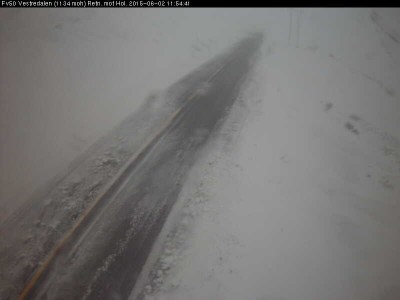
© Statens vegvesen This was the scene on Highway 50 between Hol and Aurland Tuesday morning. The road had to close because of heavy snow and poor visibility.

"It was incredible to wake up to a full snowstorm in June," Sigurd Bjåen of Hovden, in the mountains of southern Norway, exclaimed on national radio Tuesday morning. The heavy and drifting snow forced closure of several highways, with others open only for convoy-driving behind snowplows.

The state highway department (Statens vegvesen) warned of delays of up to three hours for those waiting to join convoys on Highway 7 over Hardangervidda, for example. The main Highway 134 over Haukelifjell had to close again after briefly reopening Monday evening, and Highway 51 over Valdresflye was also closed.

On Highway 55 over Sognefjellet, emergency crews had to rescue 39 people from 17 vehicles that got caught and partially buried by the snowstorm Monday afternoon. "We couldn't see a thing," Terje Weka, an experienced snowplow driver, told Norwegian Broadcasting (NRK). "There was so much wind and zero visibility. It was difficult to work, we had to just feel our way forward." That highway was closed as well.

Snowflake Cold

Australia's first day of winter brings lowest temperatures in forty years

NSW snow
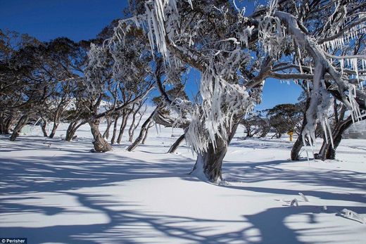
The NSW alpine resorts of Perisher (pictured) and Thredbo turned white overnight as 30cm of snow blanketed the mountains with lows of minus nine degrees
Australia is experiencing the coldest start to winter in forty years after parts of the country were buried under a foot of snow.

Temperatures plunged as low as minus nine degrees Celsius as the alpine resorts of Perisher and Thredbo in New South Wales disappeared underneath a blanket of snow on Monday evening.

Average winter temperatures across New South Wales are typically between 14 and 16 degrees Celsius.

It got as cold as 6.1 degrees Celsius in the City of Sydney, making it the chilliest morning the region has seen since 1987. Falls Creek in Victoria also received 20cm of snow overnight and Mount Buller recorded8cm, while Melbourne got off to its coldest morning in almost 40 years.


Snowflake

School bus blown off road in June snowstorm, Norway

Image
The school bus at Haukelifjell blew right off the road
1 June 2015 - It's like full winter at Sognefjellet.

Thirty-nine people have been rescued and 17 cars are stuck in the snow.

A snow plow is on its way, but it is uncertain how long it will take to get to the vehicles.

Also, many people are without power due to falling trees.

Thanks to 996bip for this info

Image
© Webcam / SognefjellhyttaFull snowstorm: several cars stuck at Sognefjellet.