Extreme Temperatures
S


Igloo

Unusual circular ice flow in Norway caught on camera


Lillehammer - Reportedly this weird phenomena has been happening for years on the river Gudbrandsdalslågen, north of Lillehammer in Norway. But this is the first time that someone has actually caught it on camera.

The peculiar ice flow is perfectly circular in shape, and spins round and round on the river. Trond Stordal, who took the video told Norway's NRK (in Norwegian) that, "I have seen this for years, and many times thought that I would try to get it on film."

"I spent some time one morning and got myself some good pictures," he added. Stordal, 48, a resident of nearby Otta, took several still pictures with an SLR and also filmed a video with his cell phone.

Comet

What killed the woolly mammoth? UCSB Professor finds evidence to support comet collision

Nanodiamond
© UCSBNanodiamond textures observed with high-resolution transmission electron microscopy: A) star twin and B) multiple linear twins.
Could a comet have been responsible for the extinction of North America's megafauna - woolly mammoths, giant ground sloths and saber-tooth tigers? UC Santa Barbara's James Kennett, professor emeritus in the Department of Earth Science, posited that such an extraterrestrial event occurred 12,900 years ago.

Originally published in 2007, Kennett's controversial Younger Dryas Boundary (YDB) hypothesis suggests that a comet collision precipitated the Younger Dryas period of global cooling, which, in turn, contributed to the extinction of many animals and altered human adaptations. The nanodiamond is one type of material that could result from an extraterrestrial collision, and the presence of nanodiamonds along Bull Creek in the Oklahoma Panhandle lends credence to the YDB hypothesis.

Igloo

Did it snow on the summit of Mount Kinabalu in Borneo?

Mount Kinabalu
© The StarMount Kinabalu looms majestically over the village of Bundu Tuhan.
Kota Kinabalu: Did it snow at Mount Kinabalu just before dawn on Jan 17 when temperatures dipped to -3°C?

A report submitted to Sabah Parks by their head ranger Martin Mogurin indicated that there were signs of snow at the summit area of the 4,101m-high mountain along the Crocker Range around 4am.

Martin said guides at the mountain submitted a report but were unable to back it up with pictures as it was dark. Sabah Parks officials are trying to verify the report.

Sabah Parks chairman Tengku Zainal Adlin, who has climbed every face of Mount Kinabalu in the last five decades, is not surprised over the snow report.

Igloo

Strange snowballs invade the U.S.

Snow Balls
© Cassie ImhoffOhio snow rollers.
A strange and rare winter weather marvel appeared overnight in Eastern states blasted by blustery winds - snow sculpted into fanciful shapes such as doughnuts and hollow tubes.

Known as snow rollers, the delicate formations are as light as meringues and may crumble when touched, but others are icy enough for play. They were a social media phenomenon today (Jan. 27), sweeping Twitter and Facebook as people from Ohio, Illinois and Pennsylvania posted images of their yards dotted with strange snowballs.

According to the National Weather Service, snow rollers need just the right combination of light, sticky snow, strong (but not too strong) winds and cold temperatures to form. It's been about 10 years since snow rollers were reported in western Pennsylvania, but snow rollers appeared in near Spokane, Wash., in 2009.

Family

Best of the Web: Polar vortex and food stamp cuts create perfect storm of hunger

Image
The freezing temperatures across the country mean higher heating costs for everyone. Many low-income families are struggling with this increase in prices. They are already under the strain of trying to afford food.

Last year 47 million hungry Americans lost food stamp benefits, and Congress may be bringing more cuts to the table. Needy families are placed in the awful situation of having to choose between heat or food.

The combination of this winter's "polar vortex" with the cuts in food stamps has created a perfect storm of increasing hunger in America.

Feeding America's CEO Bob Aiken says, "The high cost of heat this winter due to prolonged and brutal cold spells will strain many household budgets and send more people to food pantries, soup kitchens and other emergency-food charities."

In a study released prior to the cold spell, Feeding America said about 46 percent of its clients "report choosing between paying for food and paying for heating fuel or other utilities." With the massive drop in temperatures this winter, this figure is likely much higher.

In Cincinnati, Ohio, temperatures have been in the single digits or below zero multiple days this month. Sarah Cook of the Freestore FoodBank says, "We are seeing more people right now because of utility issues. "

However, the Freestore and other food banks across the country face dwindling donations following the holidays, making it tougher to keep up with any increase in demand. In addition, with the cuts in food stamps, hungry Americans are turning to food banks for more support than ever. Food banks, even with the generosity of its donors, cannot make up the difference for major cuts in federal food aid.


Snowflake Cold

Major U.S. winter storm to bring snow, ice to Gulf Coast, Georgia and Carolinas

Image
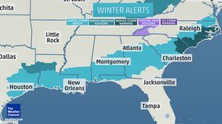
© Weather ChannelWinter Storm Alerts
We are watching for a potentially major winter storm to affect a long swath of the Deep South this week - including places better known for their beaches, balmy breezes and hurricanes. This will include some of the areas affected by Winter Storm Kronos just last week - but it includes millions of people farther east as well.

The threat stems from the combination of a bitterly cold arctic air mass plunging southward behind a sharp cold front, while moisture streams northward from the Gulf Coast. As the moisture crosses into the cold air behind the front, a swath of frozen and freezing precipitation is likely to break out.

The National Weather Service has issued winter storm watches, warnings and advisories from southeast Texas eastward along the Gulf Coast through Georgia, the southern half of South Carolina, eastern North Carolina and far southeast Virginia. For Charleston, S.C. and Savannah, Ga., it's the first winter storm watch issued for those two cities since Feb. 11, 2010. For Houston, it's the second time with a winter storm watch in just five days.

Let's step through the forecast and get into the details and uncertainties.
Image
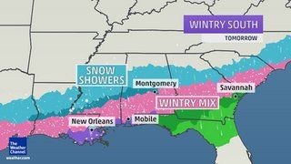
© Weather ChannelTuesday Forecast
Long Stretch of Ice and Snow

The latest blast of arctic air, already bursting south into the Midwest, will reach the Deep South Monday night. Temperatures should be at or below freezing by Tuesday morning along the Gulf Coast from Houston to Pensacola, Fla., as well as portions of the Carolina coast.

As Tuesday wears on, a broad zone of rising air will develop across the entire Gulf Coast (except for southwest Florida) and the Atlantic Coast of the Southeast, along and behind the arctic cold front. This will allow an elongated area of precipitation to develop from South Texas all the way to the Carolinas.

Cloud Precipitation

For 3 days about 100,000 residents of Kubar region in Russia were left without power due to ice rain

Krasnodar
Heating restored in Krasnodar
Heating was fully restored in Krasnodar at 8.00 am today. All boiler rooms, including 8 diesel rooms, are operating.

315 brigades were restoring power in the city. Power has been restored for 13,000 out of 29,000 people who had suffered from the power cut on January 21, caused by ice rain that had broken power lines.

80 transformer stations are yet to be turned on. 46 autonomous energy sources are operating. Specialists are restoring 0.4-KW power lines in Kopansky, Novy, Chernikov, districts of Prikubansky and Karasunsky.

Comment: A translation from a Russian news-site:
About 100 thousand inhabitants of Kuban were left without electricity after the region was hit by icy rain that damaged hundreds of transformer substations and transmission lines. According to information announced by the representatives of the Southern Regional Emergency Center, in total, 83 high voltage transmission lines and 108 transformer substations became disabled. As a result, the total power outages exceeded 50 MW, according to ITAR-TASS.

Despite these impressive figures, the MOE noted that the scale of the "blackout" could be greater. Prevention was possible thanks to the precautions taken in a timely manner by local municipalities, businesses, energy and rescue services. The organization responsible for the service areas of federal highways running through the territory of Adygea and Krasnodar Territory, after the announcement of a storm warning did everything necessary to ensure the traffic flow in a secure manner and without interruption.

To do this, they placed on duty on the roads equipment that distributes salt mixture/de-icing agents, as well as special equipment for cleaning the roadway of snow drifts.


Snowflake Cold

U.S braces itself for coldest month of the century - More snow storms expected

Image
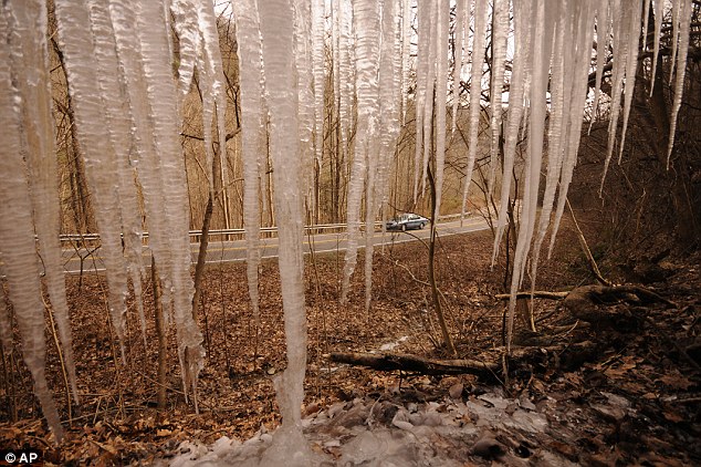
Icy grip: A motorist passes a wall of icicles on Suck Creek Road as temperatures struggle to reach the freezing point.
  • Meteorologists are forecasting yet another snow storm for the East Coast, which will arrive on Monday
  • First Super Bowl to be held in open-air stadium set to be hit by freezing cold
  • Teams on high alert game in New Jersey on February 2 could be postponed
  • The Midwest will be hit with a blast as well between Friday and Saturday, which may cause dangerous roads and flight cancellations
  • Yet another storm is expected to follow the storm scheduled for Monday and is set to hit just one or two days before the Super Bowl on February 2
  • The championship game will be held in East Rutherford, New Jersey where workers shoveled snow all day after Tuesday's unexpected whiteout
America is set for the coldest month of the century as weather forecasters predict yet another freezing blast of Arctic air - putting Super Bowl Sunday in jeopardy.

Teams have been warned to stay on high alert for changes to the scheduling of the first Super Bowl to be played in an open-air stadium.

Temperatures have already hit record lows, at times making parts of the U.S. colder than the North Pole, and are expected to plunge in the coming days.

The timing could not be worse for one of the biggest global sporting events, which will be exposed to the full force of the elements at the MetLife Stadium in East Rutherford, New Jersey on February 2.

Eric Grubman, NFL vice president of business operations, told the Denver Post: 'We are advising teams to prepare in case a contingency plan goes into effect.'

Attention

Indonesian flood victims desperate for clean water and food

Image
Huts along a river bank sit inundated by the flooded river in downtown Jakarta, Indonesia.
Indonesians in Jakarta are still reeling from the massive flooding brought on by the rainy season. While logistics and food supplies are being distributed to evacuation sites, some evacuees in small shelters claim they are being left out.

Indonesians in the capital city of Jakarta are still reeling from the massive flooding brought on by the rainy season.

Home to nine million people, the capital has already seen some 62,000 being displaced.

While logistics and food supplies are being distributed to evacuation sites, some evacuees who have sought refuge in small shelters are claiming they are being left out.

One flood victim, Tuti Mahyanti and her family have been staying at a shelter in East Jakarta for the past week.

Living in close proximity to a river and having to seek temporary shelter from the floods is not her first experience.

But it is an experience one can never get used to.

For now, her family of four have to contend with sleeping on a small carpet laid out on a carton.

Ice Cube

Winter storm brings ice to Southeast Texas

Image
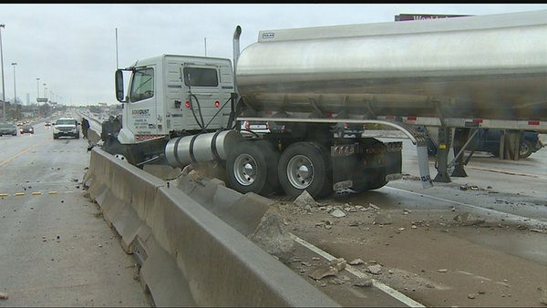
© KHOU An Arctic blast dropped temperatures and brought snow and ice to Southeast Texas overnight. The weather forced the closure of dozens of freeway ramps and overpasses were shut down due to icing.
An Arctic blast dropped temperatures and brought snow and ice to Southeast Texas overnight.

As temperatures hover in the low 30s Friday, some roads may remain icy so drivers are advised to use caution, especially on bridges and overpasses, KHOU 11 News Meteorologist Brooks Garner said.

The icy road conditions on Friday morning left many commuters stranded on Houston roadways. The slick roads were blamed for hundreds of accidents in the Houston area, including a jack-knifed 18-wheeler that slammed through a concrete barrier.

Temperatures slowly rose above freezing in the afternoon. By 5:30 p.m., most roads had been cleared for any icing.

In Huntsville, residents enjoyed a light blanket of snow that stayed on the ground through sunrise. Further south, dozens of freeway ramps and overpasses were shut down due to icing.

Most Houston-area school districts canceled classes for the day, including Houston ISD, Katy ISD, and Fort Bend ISD.

While areas from College Station to Huntsville experienced a mix of snow and sleet, those hoping for snow closer to Houston were out of luck.

By 1 p.m. the precipitation was coming to an end, but moisture and heavy cloud cover remained in the atmosphere keeping temperatures cool, KHOU 11 News Meteorologist Mario Gomez said.