Extreme Temperatures
S


Ice Cube

Russia's port city of Vladivostok hit by icy tempest

Image
© libra.anna/Instagram
Russia's Far Eastern port city of Vladivostok has been hit hard by gusts of freezing wind reaching speeds of 25 meters per second causing sea water to freeze over anything the giant waves touched.
Image
This Thursday Vladivostok's port turned into a giant slushy machine as sea water mixed with sand started freezing under gusts of cold wind in subzero temperatures.

Igloo

NASA study: Antarctic temperatures cooled over past six years

Image
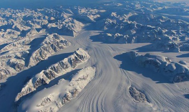
© NASAHeimdal Glacier southern Greenland, from NASA's Falcon 20 aircraft at 33,000 feet above sea level.
ANTARCTIC temperatures have cooled over the past six years, according to US space agency NASA

An intensive scientific study of both Earth's poles has found that from 2009 to 2016 overall temperature has dropped in the southern polar region.

NASA's Operation IceBridge is an airborne survey of polar ice and has finalised two overlapping research campaigns at both the poles. In the last few weeks NASA has revealed the overall amount of ice has increased at the Antarctic and the amount of sea ice has also extended. Coupled with the latest announcement of slight cooling in the area, it has fuelled claims from climate change deniers that human industrialisation is not having the huge impact on global tenperature as often is claimed.

Image
© NASA
Christopher Shuman, a University of Maryland, Baltimore County glaciologist working at Goddard, said: "Field data suggests that there's been a modest cooling in the area over the 2009 - 2015 time period, and images collected during that time by the Moderate Resolution Imaging Spectroradiometer on the Terra and Aqua satellites show more persistent fast ice (sea ice that is attached to the shore) in the Larsen A and Larsen B embayments"

However, Mr Shuman warned that in some areas of the Antarctic, glaciers continued to melt at significant levels, despite the slight temperature drop. At the south polio, the mission observed a big drop in the height of two glaciers situated in the Antarctic Peninsula. Mr Shuman added: "These IceBridge measurements show that once the ice shelves collapse, even some cooling and a good deal of persistent sea ice is not able to hold back these larger glaciers and they continue to lose mass overall."

Comment: See also:


Ice Cube

More than 1 foot of snow blankets parts of the Western U.S.

Image
© Via twitter@LaurenKYVZTraffic backed up on Highway 97 in Bend, OR.
Snow, sleet and freezing rain could snarl Thanksgiving and weekend travel.

Bend, Oregon, reported 13-14 inches of new snow as of Tuesday night, with snowfall rates of 4 inches in 3 hours, bringing traffic to a standstill on U.S. 97. This in an area that averages only 24 inches of snow each season. Up to a foot of snow in the Sierra snarled traffic on Interstate 80 over Donner Summit as well. Up to 22 inches of snow was reported at Kirkwood Mountain Resort south of Lake Tahoe.

Meanwhile, numerous winter storm watches, warnings and advisories have been issued across the West from the northern Rockies to the Great Basin, Sierra and Tehachapis of California, also for a large swath of the central and southern Plains from New Mexico to Iowa.

Snow started to pile up on Tuesday across portions of the interior Northwest, Sierra Nevada and far northern Rockies. Some freezing rain was also reported in the Columbia Basin.

This system will head into the Plains on Thanksgiving Day and continuing into much of the weekend, bringing a mess of snow, sleet and freezing rain.

It is possible that enough freezing rain will fall to bring down trees and power lines and make for dangerous travel in parts of the central and southern Plains.


Comment: Winter storm brings record breaking snowfall to Illinois, Wisconsin, Iowa, South Dakota


Blue Planet

UN Report: Major rise in weather disasters over last 2 decades

Image
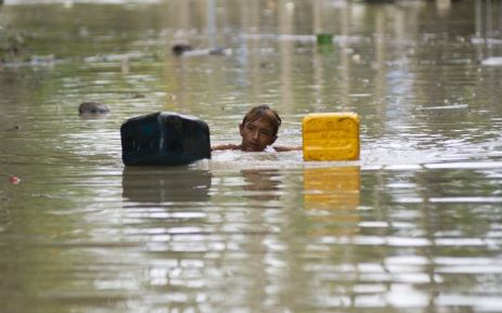
© AFPA flood-affected resident swims through floodwaters in Kalay, upper Myanmar’s Sagaing region on August 3, 2015. Relentless monsoon rains have triggered flash floods and landslides, destroying thousands of houses, farmland, bridges and roads with fast-flowing waters hampering relief efforts.
Since 1995, weather disasters have killed millions of people & left billions injured & homeless.

Weather-related disasters such as floods and heatwaves have occurred almost daily in the past decade, almost twice as often as two decades ago, with Asia being the hardest hit region, a UN report said on Monday.

While the report authors could not pin the increase wholly on climate change, they did say that the upward trend was likely to continue as extreme weather events increased.

Since 1995, weather disasters have killed millions of people, left billions injured, homeless or in need of aid, and accounted for 90 percent of all disasters, it said.

A recent peak year was 2002, when drought in India hit 200 million and a sandstorm in China affected 100 million.

But the standout mega-disaster was Cyclone Nargis, which killed 138,000 in Myanmar in 2008.

Snowflake

A foot of snowfall causes problems in Croatia

Image
Almost the entire Lika region was caught in snowy weather last night. In Gospić, more than 30 centimetres of snow has fallen, while in mountainous areas the snow cover is even higher. Snow has caused the falling down of many trees which have damaged electrical lines, so the wider area of ​​Gospić was without power this morning. Director of Elektrolika Ernest Petri said that two transmission lines that supply electricity to Gospić have broken down. There are problems with the local phone lines as well, reports Index.hr and Vecernji List on November 22, 2015.

Snow and strong winds are causing traffic problems in the Primorje region. The Lika-Senj Police Department has announced that the Adriatic highway from Karlobag to Sveta Marija Magdalena is completely closed down, and on all the roads in Lika winter tyres are mandatory.

Snowflake

Chicago's first snow of the season brings largest November snowfall in 120 years

Chicago snowfall
© Brian Cassella / Chicago TribuneSnow falls in Chicago's Logan Square neighborhood Nov. 21, 2015.
The season's first snowfall dropped as much as 17 inches across Chicago's northern suburbs, and the total of 11.2 inches at O'Hare International Airport made it the largest November snowfall in 120 years.

The steady stream of snow began Friday evening and carried into Saturday, bringing cold winds and slushy puddles to Michigan Avenue. But it also fashioned a wintry backdrop to the annual Magnificent Mile Lights Festival, transporting Chicagoans into a life-sized holiday snow globe.

The chill didn't bother the Kendalls, who traveled from Northwest Indiana for the festivities. They stood in Pioneer Court bundled in snow gear, relishing bites of candy-cane-garnished cheesecake as heavy snowflakes plopped onto their noses.

"It rings in the beginning of Christmas season," said Jessica Kendall. "The roads are warm, the snow's melting and we had a nice, wintry drive."

The storm hit hardest in the northern suburbs.

Lake County was walloped. By about 2 p.m. Saturday, there were reports of 17 inches in Grayslake, 16.5 in Hawthorn Woods, and 15.5 inches in Mundelein, said National Weather Service meteorologist Jamie Enderlen.

McHenry County also was socked, with 13.6 inches in Bull Valley, 12.5 inches in Woodstock and 9.5 inches in Hebron by about 7 a.m. Saturday, according to the weather service.

Snowflake Cold

Winter storm brings record breaking snowfall to Illinois, Wisconsin, Iowa, South Dakota

Image
Winter Storm Bella not only brought the first, not to mention locally heavy, accumulating snow of the season for some in the Great Lakes and Midwest, but also was one of the heaviest November snowstorms of record for some.

Scroll down to the "snowtables" section for a list of records set during this storm.

Parts of the Sioux City, South Dakota metro area picked up over a foot of snow in an intense snowband Friday. Snow has since ended, there, but has now spread into the Great Lakes, with some totals over 10 inches already coming in from parts of Wisconsin and northern Illinois.

Winter storm warnings continue from parts of northern Illinois, southern Wisconsin, northern Indiana and southern Lower Michigan, including the Quad Cities, Rockford, Milwaukee, Chicago, South Bend and the north and west Detroit suburbs. In the much of the Upper Midwest, this means a likelihood for at least 6 inches of snow in 12 hours, or 8 inches of snow in 24 hours.

Winter weather advisories are posted for other parts of Illinois, Indiana, northwest Ohio and Lower Michigan, where somewhat lower snowfall totals are expected. Despite lacking strong surface low pressure, these systems are notorious heavy snow generators in the Midwest.
Image
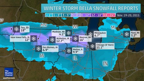
Snowfall Reports - A sampling of snowfall totals since Thursday.
Snowfall Totals So Far

As of Saturday midday, numerous locations from southeastern South Dakota to southern Wisconsin and northern Illinois have reported a foot or more of snow from the storm.

Here is a sampling of official snowfall totals around the area, by state:
  • South Dakota: Tea (18 inches), Sioux Falls Regional Airport (7.2 inches)
  • Iowa: George (17 inches), Waterloo (12.7 inches), Dubuque (10.2 inches), Des Moines (6.9 inches)
  • Nebraska: Near Bloomfield (16 inches), South Sioux City (6.5 inches), Valentine (4 inches)
  • Minnesota: Worthington (8 inches)
  • Illinois: Grayslake (16 inches), Chicago O'Hare (11.1 inches), Moline (9.9 inches), Rockford (8.6 inches),
  • Wisconsin: Near Footville (17 inches), Janesville (11.5 inches), Milwaukee (6.7 inches), Madison (4.1 inches)
  • Michigan: Rives Junction (8 inches), Kalamazoo (5.3 inches), Flint (3.2 inches), Detroit Metro Airport (1 inch)
  • Indiana: Crown Point (5 inches), Lafayette (3.5 inches), near South Bend (3 inches), Tipton (2 inches)
Bella also produced the season's first flakes as far south as northwest Arkansas Saturday morning, and left a dusting of snow in Springfield, Missouri, as well.
Comment: To the horror of global warming alarmists...


Snowflake Cold

Iceland in the grip of bitter cold snap

Image
© RaxFrost and snow in parts of Iceland today.
Anybody venturing outside in Iceland yesterday evening will have found that predictions of bitterly cold weather were not exaggerated.

Even the most extreme forecast minimum temperature was reached - it was exactly -20°C at the Icelandic Met Office weather station at Sandbúðir in inland South-East Iceland early this morning.

It is currently -9°C in the capital Reykjavik and temperatures will struggle to exceed -4°C at their very warmest today.

Residents of Akureyri woke up this morning to temperatures of -10°C and a blanket of white, after heavy snowfall yesterday evening. A Primera Air jet flying a charter flight from Tenerife to Akureyri was forced to divert to Keflavík (KEF) as visibility in North Iceland was so bad.

Snowflake Cold

Alaska endures bitter temperatures of minus 24 — and it's only November

Image
It's only November and Alaska has been plunged into a deep chill, with frostbite-inducing temperatures dipping as low as 24 below zero early Monday.

Fairbanks was subjected to bitter temperatures of minus 22 degrees Sunday and was forecast to endure almost as bad on Monday night, according to forecasters.

"With these sorts of temperatures, people are at risk of frostbite within a minute of stepping outside, if not less time than that," according to Kevin Roth, lead meteorologist at The Weather Channel. "You've got to be bundled up from head to toe with no exposed skin. With this kind of cold, you walk outside and it really takes your breath away if you're not used to it."

Temperatures were about 20 degrees below average but were some way off record lows, Roth said, adding the state was not expected to go above zero until Thursday.

Snowflake

Snowfall shuts 290 village roads in eastern Anatolia, Turkey

Image
Meteorological officials warned citizens to be careful and cautious, being particularly alert for high avalanche danger.

In Erzurum 173 village roads are closed due to snow, and 117 were closed in Ardahan, for a total of 290.

Highways teams continue to work for the opening of village roads so that transport can resume.

Also yesterday, Erzurum Regional Directorate of Highways 12 and Erzurum Metropolitan Municipality were stranded due to snow and subsequently rescued.

Thanks to Argiris Diamantis for these links

Just before the Climate Summit in Paris, the MSM keeps quiet about this kind of news," says Argiris.