Extreme Temperatures
S


Igloo

Arctic blast sets stage for winter storm to threaten the Northwest U.S.

Image
The blast of arctic air spreading across the nation will set the stage for a winter storm to threaten the Northwest later this week.

Frigid air will not only spend this week pouring across the eastern two-thirds of the nation, but will also continue to spill into the Northwest.

As the cold air expands southwestward, gusty winds will create even lower AccuWeather.com RealFeel® temperatures through Wednesday.

As the cold air squeezes through the Columbia Gorge, winds will pick up speed in a fashion similar to what happens between buildings in a city. Gusts of 40 to 60 mph can occur near the western mouth of the gorge into Wednesday.

The strongest winds will whip Troutdale, Oregon, with gusts of 50 mph expected in Portland.

Such winds could cause tree damage and power outages. Dangerous cross-winds will threaten high-profile vehicles, including those traveling Interstate-84 as it snakes along the Columbia River and the portion of I-5 in the Portland, Oregon, area.

As the winds die down later Wednesday, attention will then turn toward a new Pacific storm due to arrive late in the week.

While the storm will be far from the strongest to slam the region, the presence of the cold air will set the stage for snow and ice to fall outside of the mountains and create travel hazards.

Current indications point toward an icy mix developing along the I-5 corridor in northern Oregon and southern Washington Wednesday night through Thursday morning.
Ice Cube

Northern Rockies snowstorm to expand to Minneapolis, Great Lakes

The snowstorm unfolding across the northern Rockies will spread a swath of snow to Minneapolis and the upper Great Lakes through the first part of the week.
Image
Before reaching the Great Lakes, the system is expected to deliver snow from the Rocky Mountains to the northern Plains with accumulating snowfall reaching as far south as Denver.

The snow will then begin to build into the northern Great Lakes, moving into the region on Monday and continuing into Tuesday night.

Due to the path of the storm, it appears as though some of the bigger cities around the Great Lakes, such as Chicago and Detroit, will miss out on the snow.

The heaviest snow is expected to focus on a zone stretching from northern Wisconsin to central Ontario. A foot or more of snow will fall over this area with localized pockets receiving as much as 2 feet of accumulation.

Gusty winds also accompanying this storm will result in blowing and drifting snow.

While blizzard conditions are not expected, winds gusting up to 30 mph can greatly reduce visibility, resulting in major travel disruptions.

This wind will also cause AccuWeather.com RealFeel® temperatures to be held to the teens and single digits on Monday in places such as Minneapolis, making it dangerous for people to spend extended periods of time in the outdoors without wearing proper clothing.

Snowflake Cold

Siberian Express to bring an early -30 degrees F to Wyoming, Montana

Image
Even though it's still early November, a January-like cold wave just entering Montana and the Dakotas on Sunday will bring 30 below zero temperatures to scattered locations in Montana and Wyoming by Wednesday morning.

The cold will fill the nation's midsection by mid-week, with no let up in sight. The coldest air to arrive in a series of reinforcing surges is still a week away.

Temperatures are forecast to run 15 to 30 deg. F below normal for at least 5 days over a large portion of the central U.S. starting late in the coming week.

On individual days the temperatures will be as much as 50 deg. F below normal for this time of year, which is quite exceptional. The air mass temperature (850 mb, ~5,000 ft. altitude) will be as much as 4.5 standard deviations below normal, which is less than 1 in 100,000 in probability terms.

Snowflake Cold

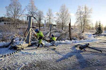
Snow storms cause huge power outage in Ostrobothnia, Finland

Image
© Str / Lehtikuva.Power company workers are repairing electric poles to restore power supply in Pietarsaari area on Wednesday.
Mercury dives to below 25 °C in Utsijoki

Snow storm caused massive power outage in Pietarsaari region of Ostrobothnia on Wednesday morning.

More than 40,000 customers of the energy company Herrfors were left without power in Pietarsaari, Uusikaarlepyy, Vöyri, Oravais and Kruunupyy areas.

The power outage in the network happened at around half past six in the morning and lasted for about an hour.

Meanwhile, the lowest winter temperature was recorded in Utsijoki.

According to the Met Office, a temperature reading of minus 25 degrees Celsius was recorded at Kevojärvi in Utsijoki following a cold wave on Tuesday night.


On the other hand, abundant snow had fallen in Kainuu since Tuesday night. Snow accumulated to more than 20 centimetres in some places. Road conditions were hampered in some places in northern Ostrobothnia.

Ice Cube

Cold snap sets records in several districts of south Florida

Image
The National Weather Service says brisk temperatures Sunday in the Naples area have broken the previous record.

Temperatures in the area only reached a high of 71 degrees, which makes it the area's coolest high temperature since 1962, when the high topped out at 75 degrees, said Barry Baxter, a meteorologist at the National Weather Service.

Temperatures in South Florida and the Keys also have broken records.

The temperature fell morning to 52 degrees in Miami, breaking the previous record of 54 degrees in 1993. In West Palm Beach, the temperature dipped to 49 degrees, below the previous record of 51 degrees in 1993.

The low temperature in Key West fell to 61 degrees, breaking the previous record of 62 degrees set in 1957.

Temperatures only reached a high of 71 degrees in Miami, breaking a record set at 73 degrees in 1949. In West Palm Beach, temperatures peaked at 69 degrees, breaking the 1964 record of 72.

Ice Cube

Central and Eastern U.S. states preparing to be hit with an early 'Polar Vortex'

Image
The atmosphere is preparing to send part of the polar vortex southward toward the United States next week with an outbreak of arctic air and lake-effect snow.

The polar vortex is a large pocket of very cold air, typically the coldest air in the Northern Hemisphere, which sits over the polar region. Occasionally, this pocket of very cold air can get dislodged farther south than normal, leading to cold outbreaks in Canada and the U.S.

The main blast of cold air associated with the plunging polar vortex will swing southeastward into the Central and Eastern states spanning Sunday, Nov. 9, to Friday, Nov. 14, 2014. According to AccuWeather Long Range Expert Paul Pastelok, "Areas from the northern and central Plains to the Great Lakes, the upper Gulf Coast and the Appalachians will feel significant impact from the arctic outbreak."

Snowflake

Early heavy snowfall in the Northern Hemisphere

Image
Early and unusually heavy snowfalls effected several regions across the Northern Hemisphere in October 2014.


Source: Adapt 2030

Snowflake

2 metres of heavy snowfall in Turkey - 36 village roads closed

Image
50 cm (20 inches) of snow in Artvin. On a plateau near Rize a car was stuck in 2 meters of snow.

According to Special Provincial Administration teams, the snow was 50 cm (20 inches) deep in higher elevations.

A written statement from the General Directorate of Meteorology asked citizens to be cautious due to the expected heavy snowfall in some provinces. It warned: 'Heavy Snow Coming!'

Artvin, Ardahan and northern districts of Rize and Erzurum expected heavy snowfall in the higher parts.

Image

Snowflake

Heavy snowfall closes Brenner motorway in Austria

Image
© APA/BARBARA GINDLSnow in Tyrol.
Heavy snowfall brought traffic on the Brenner motorway (A13) to a complete standstill for several hours on Thursday morning in Tyrol.

Trucks formed long convoys in both directions and even snowploughs had trouble getting through.

Due to dangerous driving conditions and the need to clear snow the motorway was closed between the Brenner pass and Schönberg for a distance of around 20 km to all traffic for several hours, a spokeswoman for the Austrian motoring association (ÖAMTC) told the Austrian Press Agency.

Trucks travelling in the direction of Italy were stopped at Vomp and had to park on the hard shoulder of the Inn Valley motorway.

Snowflake

Over 2,000 people evacuated in Iran due to heavy snowfall

Image
Over 2,000 people were evacuated in 11 provinces of Iran due to heavy snowfalls and blizzards, the Iranian Red Crescent Society's representative, Hussein Derahshan said Nov. 5, the Fars news agency reported.

He said some 220 of people evacuated were provided with temporary shelter.

Derahshan added that classes were suspended at schools in the cities of Sereyn, Ardabil and Nir of Ardebil province, and the city of Firozkoh of Tehran province due to heavy snows.

It has been three days that the snowfalls are continuing in Iran's northern regions, including in the provinces of Qazvin, West Azerbaijan, Gilan, Mazandaran, Ardabil, Gulistan, East Azerbaijan and others.

In some places the snow depth is over 10 centimeters.