Extreme Temperatures
S


Attention

Cold weather records for July in Saskatchewan, Canada

Single digit lows recorded throughout the province
Image
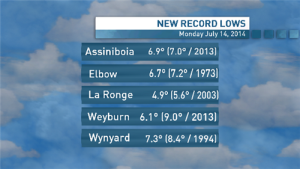
© CBCFive cold weather records were set in Saskatchewan Monday morning.
Saskatchewan evenings have definitely been on the cool side lately, with at least five low temperature records falling Monday morning.

Assiniboia, La Ronge, Weyburn and Wynyard all broke July 14 records with single digit overnight lows.

Elbow, meanwhile, was colder this morning than it has been on this date since 1973.

Here are the communities, their Monday low temperatures in Celsius degrees and previous lows:

* Assiniboia 6.9 (7.0, 2013)

* Elbow 6.7 (7.2, 1973)

* La Ronge 4.9 (5.6, 2003)

* Weyburn 6.1 (9.0, 2013)

* Wynyard 7.3 (8.4, 1994)

According to CBC weather specialist Farah Singh, it's all thanks to cool air sweeping down from the north, combined with clear skies that let the heat escape at night.

Sunday was cool in the evening and early morning, too, with cold weather records for July 13 set in Elbow (7.0), Meadow Lake (4.0), Moose Jaw (7.5), Rosetown (6.3), Spiritwood (5.9), Uranium City (4.8) and Weyburn (6.1)
Igloo

Record low temps hit Winnipeg in July!

Thermometer
© cjob.com
It's not the kind of record you want to be hearing about in the middle of July.

David Phillips, senior Climatologist for Environment Canada, joined Richard and Kathy on Winnipeg's Morning News. He confirms that yesterday's high, 15.7 degrees Celsius, was the coldest July 13th in Winnipeg since 1884.

He puts the reasoning behind a type of polar vortex - that cold low which is sitting over the heart of North America.

However, the good news is that it will be short lived according Phillips. He says starting tomorrow the mercury will continue to rise and by the weekend we should be hitting temps around 30 degrees.

That's, not the end of it either. Phillips forecasts the heat to continue over the next couple of months.

Snowflake

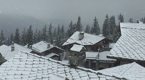
The Ice Age looms: Heavy snowfall forecast in the Alps this week

Image
More weather that is not supposed to happen.

-------------------------------------------------------------------------------------------------------------------------------------------

11 July 2014 - "Although summertime snowfall high up in the Alps is not an unusual occurrence, snowfall down to 6000 feet elevation IN JULY is something that wasn't supposed to happen nowadays," writes P. Gosselin on notrickzone.com.

20 inches of snow

Last Tuesday, July 8, the Swiss online Blick reported that meteorologists were predicting snowfall down to 1800 meters elevation (6000 ft.), forecasting up to 50 cm (20 inches) of snow in the Canton of Valais.

Blick writes that the snowfall presented a problem for grazing cattle, which would either have to be brought down to lower elevations or housed in mountain shelters stocked with feed.

By evening, passes were closed and avalanche warnings had been issued.

Snowflake

First ever snow falls in South Urals in mid-summer

Snowfall in South Urals
© RIA Novosti/Aleksandr Kondratuk
Heavy rain in the town of Zlatoust in Russia's South Urals on Sunday, July 12, suddenly gave way to a blizzard in a rare twist of weather for the summer season.

"It wasn't just rain and snow, but real snowfall with snowflakes as white as during winter. T melted quickly, of course. A fantastic sight," ITAR-TASS quotes an eyewitness, Valery Semyannikov, as saying.

In some areas of the Chelyabinsk region, snow lay 5-10 cm thick.

It's the first ever mid-summer snowfall in the South Urals.

The Chelyabinsk weather service predicted "wet and windy weather with moderate to heavy rain throughout the region, thunderstorms and soft hail in the east and ice hail in the mountains."

Snowflake Cold

Coldest temperatures hit Australia's Sunshine Coast in over a century

Image
© Terry West, Southern Downs Weather and StormchasingCows among the frost.
If you are lucky enough to be reading this from the comfort of your blankets, it might be best to stay there, as Brisbane has hit its coldest temperatures in 103 years. Not since July 28 1911 has Brisbane felt this cold, getting down to a brisk 2.6C at 6.41am.At 7am, it inched up to 3.3C.

Matt Bass, meteorologist from BOM, said the region was well below our average temperatures.
"If it felt cold, that's because it was, breaking that record is pretty phenomenal for Brisbane," Bass said. "The average for this time of year is 12C, so Brisbane was about 9C below average, it is pretty impressive really, to have the coldest morning in 103 years is a big record."

The coldest place across the state was Oakey which got down to -6.1C, which was the coldest temperature for the town since 2011. Brisbane wasn't the only town hitting landmark temperatures with Clermont breaking its coldest record two days in a row. "Clermont in the coal fields got down to -4.5 which is a new record for them, their previous record was -3.7, which was set yesterday, so they've re-broken their record two days in a row."


Snowflake

French Alps hit by some very unseasonal July snowfalls

Image
© WebcamThe French Alps looked more like a winter wonderland this week as the rotten summer weather continued in France.
Holidaymakers in the Alps in recent days would have been forgiven for thinking they had come in the wrong season after the region was hit by some very unseasonal snowfalls. There was bad news for sunseekers too with the sun set to stay away for much of July.

Parts of the Alps looked like a winter wonderland on Thursday as summer snow continued to fall, disrupting the usual holiday activities.

The regional newspaper Dauphiné Libere reported that tourists in the town of La Rosière were asking shopkeepers for toboggans so they could go sledging on the slopes.

At the resorts of Tignes and Val d'Isere, the snowfall ruined the chances of activities such as flyboarding and mountain biking.

Image
The resort of La Rosiere

Ice Cube

Ice still present on Lake Superior in July!

Image
The mainstream media tries to pretend that ice remained on Lake Superior "only" into June.

"How about July?"asks reader E Stephens.

"We should name icebergs still floating in Lake Superior in July after infamous AGW scientists. This one is Gavin," says Tilly LaCampagne via Twitter.

See photo dated 11 July 2014:

Thanks to E Stephens for this link

Snowflake Cold

Coldest June ever recorded in Antarctica

Image
© John Weller
Antarctica continues to defy the global warming script, with a report from Meteo France, that June this year was the coldest Antarctic June ever recorded, at the French Antarctic Dumont d'Urville Station.

According to the press release, during June this year, the average temperature was -22.4c (-8.3F), 6.6c (11.9F) lower than normal. This is the coldest June ever recorded at the station, and almost the coldest monthly average ever - only September 1953 was colder, with a recorded average temperature of -23.5c (-10.3F).

June this year also broke the June daily minimum temperature record, with a new record low of -34.9c (-30.8F).

Other unusual features of the June temperature record are an unusual excess of sunlight hours (11.8 hours rather than the normal 7.4 hours), and unusually light wind conditions.

Snowflake Cold

Shocking summer return of poor man's polar vortex to eastern U.S. next week

Image
© Washingtonpost.com
Call it the ghost of the polar vortex, the polar vortex sequel, or the polar vortex's revenge. Meteorological purists may tell you it's not a polar vortex at all. However you choose to refer to the looming weather pattern, unseasonably chilly air is headed for parts of the northern and northeastern U.S at the height of summer early next week.

Bearing a haunting resemblance to January's brutally cold weather pattern, a deep pool of cool air from the Gulf of Alaska will plunge into the Great Lakes early next week and then ooze towards the East Coast.

Of course, this is July, not January, so temperatures forecast to be roughly 10 to as much as 30 degrees below average won't have quite the same effect.

But make no mistake, in parts of the Great Lakes and Upper Midwest getting dealt the chilliest air, hoodies and jeans will be required. Highs in this region could well get stuck in the 50s and 60s - especially where there is considerable cloud cover.

Wednesday morning's lows may drop into the 40s over a large part of the central U.S. Remember, this is July!


Igloo

Co-founder of Greenpeace: 'I fear global cooling'

Image
© Cfact.org
Moore: 'President Obama seems to say it is sufficient to say the 'science is settled'. It is hollow statement with no content.

On Kids: 'Change the way our kids are being taught about this subject because if we don't there will be a whole generation of people who are just blindly following this climate hysteria.'

Ecologist Dr. Patrick Moore, co-founder of Greenpeace, warned "I fear a global cooling," during his keynote address to the Ninth International Conference on Climate Change in Las Vegas on Tuesday. Moore, who left Greenpeace in 1986 because he felt it had become too radical, is the author of "Confessions of a Greenpeace Dropout: The Making of a Sensible Environmentalist." (Watch climate conference live here)

Moore noted that a cooling would adversely impact agriculture, and said: "Let's hope for a little warming as opposed to a little cooling. I would rather it got a little warmer." (Watch Moore video here at the Heartland Institute event)

Moore noted that "the U.S. is currently been cooling" and noted that there has been "no global warming for nearly 18 years." He also mocked the notion that "everything is due to global warming."

"If it warms two degrees, hopefully more in Canada in the North...maybe it would be a good thing if it did," Moore explained.

Comment: To understand what is going on with the climate change here on the big blue marble, read the Comet and Catastrophe Series on SOTT.