Earthquakes
S


Bizarro Earth

Laos: Earthquake Magnitude 4.6

Image
© USGS
Date-Time:
Wednesday, February 23, 2011 at 15:53:17 UTC

Wednesday, February 23, 2011 at 10:53:17 PM at epicenter

Location:
18.926°N, 101.734°E

Depth:
16.2 km (10.1 miles) (poorly constrained)

Region:
LAOS

Distances:
96 km (60 miles) E (80°) from Muang Nan, Thailand

116 km (72 miles) SSW (203°) from Louangphrabang, Laos

141 km (88 miles) NW (318°) from VIENTIANE, Laos

Phoenix

Two US volcanoes making news: Kilauea and St. Helens

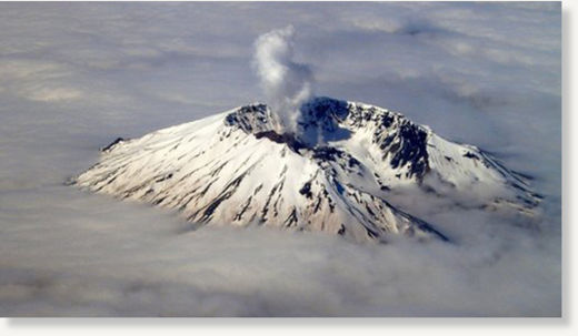
Mount St Helens
© Big ThinkAn undated aerial image of Mount St. Helens, Washington.
We've talked a lot about volcanoes in other parts of the world, but now we have two UF volcanoes making some news (although neither because they're having a large eruption):

Hawai'i: The lava lake at the Halema'uma'u Crater in Kilauea has reached new heights - in fact, the lava lake had gotten high enough (~77 meters below the crater floor) in the pit crater that there was some thoughts that it might spill out onto the floor of the crater. However, that fate is unclear now as the pit crater itself is collapsing into the lava lake, with large chunks of the rim falling in on Monday. These chunks, some as large as 120 meters x 5 meters, fell into the lake and produced small plumes of ash and gases along with very obvious popping sounds heard as far as half a mile away. You can hear some of the noises and watch some quicktime movies of the activity at the Halema'uma'u Crater over on the Hawaii Volcano Observatory website. Collapses in the pit crater in 2009 blocked off the lava lake from view, but quickly the lava was able to retake the crater. Seismicity related to the upper east rift zone of lava seemed to peak late last week, which might suggest that the influx of new basaltic magma might be waning. Be sure to check out the great time lapse videos (this one from Pu'u O'o) from Eruptions readers along with all the Kilauea the webcams as well. UPDATE: Speaking of Pu'u O'o time lapse video, here is a new one from the USGS as well.
Arrow Up

Christchurch earthquake death toll rises with hundreds still missing: images from aftermath


Curfew and cordon thrown around rescue zone in centre of New Zealand city, where 75 are confirmed dead and 300 missing

Police have a declared a curfew in central Christchurch as aftershocks from Tuesday's earthquake struck the city.

The death toll from the 6.3-magnitude quake has reached 75 and is expected to rise. Three hundred people are missing, with Ireland's department of foreign affairs confirming that two Irish passport holders were killed.

Reports of Britons among the dead have not been confirmed. The British high commission, which is providing consular assistance in Christchurch, said it had received no information as yet of any British casualties.

Officials have urged Christchurch people to stay at home unless travel is essential. Locals venturing into the city to view the damage would hamper rescue efforts, said Police Superintendent Dave Cliff. He warned of the danger of "criminal elements" and announced a strict exclusion zone around the city's "four avenues" from 6.30pm. Six arrests for burglary have been made.
Image
© Sarah Ivey/APEastern suburbs of Christchurch lie flooded

Bizarro Earth

Italy, Mt Etna: Second Eruption in 2011

Etna
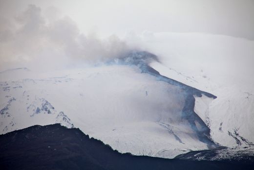
© Héloïse PicotLava flow emitted during Etna's paroxysm of 18 February onto the western flank of the Valle del Bove, seen from the village of Stazzo at about 13:00 GMT.
The second paroxysmal eruptive episode of the year 2011 from the Southeast Crater occurred on 18 February, 36 days after the previous episode (12-13 January 2011). The full duration of this episode was about 11 hours, with strong Strombolian activity and pulsating lava fountains. Although inclement weather precluded continuous direct observation of the activity, it seems that qualitatively this event was similar to its predecessor, but probably less energetic.

The paroxysm has taken place once more at the pit crater located on the lower eastern flank of the Southeast Crater cone, the only active eruptive vent at this summit cone since the summer of 2007.

The paroxysm was preceded by an explosive sequence presumably from the Northeast Crater, on the late evening of 16 February. Also in that case, direct visual observation was difficult due to the presence of cloud cover.

The onset of today's paroxysm was abrupt, and thus quite different from the long buildup phase that led to the episode of 12-13 January.

Radar

Earthquake Shakes Up Suez Canal as Iran Warships Approach

warship @ Suez larger
© Israel news photo
An earthquake measuring 5.9 on the Richter scale shook up residents at the entrance to the Suez Canal early Monday morning, 48 hours before two Iranian ships, a frigate and a supply vessel, are expected to enter the canal.

The National Institute for Astronomical and Geophysical Research reported that tremors from the 3 a.m. quake lasted for 27 minutes, but caused no damage.

The ships had originally been expected to enter the Suez today (Monday), but Egyptian officials announced the delay this morning, without explanation.

Iran inexplicably announced Sunday morning that two of its warships had crossed the Suez, a report that was thoroughly denied by Egyptian authorities. Iranian media did not mention the ships on Monday, and the false report may have been for local consumption.

Bell

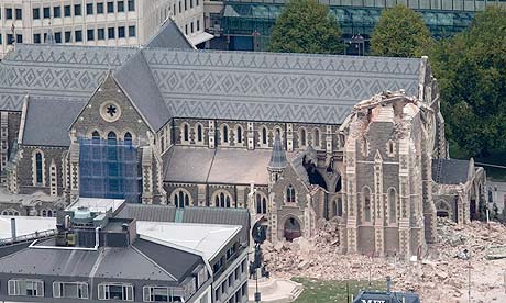
Best of the Web: Christchurch spire crumbles as death toll rises in another devastating New Zealand earthquake

Image
© Mark Mitchell/APCould it be any more symbolic? The second devastating earthquake to hit New Zealand's second-largest city in 5 months topples Christchurch Cathedral's spire.
Video taken moments after a large earthquake shattered central Christchurch. By Daniel Tobin:


Attention

Deadly 6.3 Magnitude Quake Rocks New Zealand, Topples Buildings

A strong quake hit New Zealand's second-biggest city of Christchurch on Tuesday for the second time in five months, toppling buildings, causing "multiple fatalities," trapping people beneath rubble and sparking fires.

Local TV showed bodies being pulled out of rubble strewn around the city center, though it was unclear whether any of them were alive, but police reported multiple fatalities after the 6.3 magnitude quake struck during the busy lunchtime.

"I was in the square right outside the cathedral - the whole front has fallen down and there were people running from there - there were people inside as well," said John Gurr, a camera technician who was in the center of the city when the quake hit.

"A lady grabbed hold of me to stop falling over ... It's not nice at all. We just got blown apart. Colombo Street, the main street, is just a mess ... There's lots of water everywhere, pouring out of the ground - its liquefaction - it's an absolute mess."

Bizarro Earth

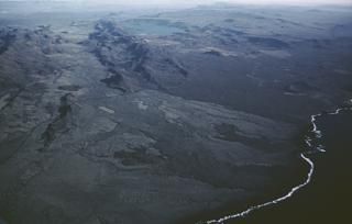
Iceland: Small earthquake swarm in Krísuvík volcano

Krísuvík
© Unknown
The Krísuvík volcanic system (also spelled Krysuvik) consists of a group of NE-SW-trending basaltic crater rows and small shield volcanoes cutting the central Reykjanes Peninsula west of Kleifarvatn lake. Several eruptions have taken place since the settlement of Iceland, including the eruption of a large lava flow from the Ogmundargigar crater row around the 12th century. The latest eruption at Krísuvík took place during the 14th century.
Currently there is a small earthquake swarm in Krísuvík volcano. This earthquake swarm is small and is only about 20 or so earthquakes at current time. It is impossible to know if this earthquake swarm is going to continue or grow at present time. But it is not uncommon in this area for a small earthquake swam to be a warm up for a larger one. But as always there is just a wait and see what happens in the area.

Bizarro Earth

Earthquake Magnitude 6.3 - South Island of New Zealand

Christchurch Quake_210211
© USGSEarthquake Location
Date-Time:
Monday, February 21, 2011 at 23:51:43 UTC

Tuesday, February 22, 2011 at 12:51:43 PM at epicenter

Time of Earthquake in other Time Zones

Location:
43.600°S, 172.710°E

Depth:
5 km (3.1 miles)

Region:
SOUTH ISLAND OF NEW ZEALAND

Distances:
NEAR Christchurch, New Zealand

225 km (140 miles) SSE of Westport, New Zealand

305 km (190 miles) SSW of WELLINGTON, New Zealand

310 km (190 miles) NE of Dunedin, New Zealand

Bizarro Earth

Australia: Earthquake Magnitude 4.7 - Northern Territory

Image
© USGS
Date-Time:
Monday, February 21, 2011 at 21:59:35 UTC

Tuesday, February 22, 2011 at 07:29:35 AM at epicenter

Time of Earthquake in other Time Zones
Location:
21.069°S, 135.432°E

Depth:
9.8 km (6.1 miles)

Region:
NORTHERN TERRITORY, AUSTRALIA

Distances:
334 km (208 miles) NNE (29°) from Alice Springs, Australia

1180 km (733 miles) WSW (245°) from Cairns, Australia

1744 km (1084 miles) SE (144°) from DILI, East Timor