Earthquakes
S


Bizarro Earth

Earthquake jolts China's Three Gorges Dam

Image
© chinatourguide.com
An earthquake measuring 3.2 on the Richter scale hit a central China region where the world's biggest water reservoir the Three Gorges Dam is located, though no harm to the structure was reported.

The tremor hit Zigui County of Yichang City in Hubei Province at 3:42 am and its epicentre was located at five km below ground, according to the China Earthquake Networks Center.

No casualties were reported though the earthquake was felt across Zigui, state-run Xinhua news agency said.

"The minor earthquake has not affected the Three Gorges Dam, which can endure far stronger earthquakes," Hu Xing'e, vice head of the management bureau of the project with the China Three Gorges Corporation said.

She said that no earthquake-triggered landslides have been reported in the reservoir area and all power generating units and ship locks are working normally.

Bizarro Earth

Jakarta shakes as magnitude 5.8 quake hits Bandung

Jakarta Quake
© USGS Screen ShotThe location of the earthquake, according to the United States Geological Survey.
A magnitude 5.8 earthquake struck the district of Bandung, West Java, Thursday night shaking buildings as far away as Jakarta and Banten, according to data released by the United States Geological Survey.

The earthquake's epicenter was 163 kilometers below ground, according to Indonesia's Meteorology, Climatology and Geophysics Agency (BMKG). The Indonesian agency reported the earthquake's epicenter as 28 kilometers southeast of Cianjur, West Java.

Bizarro Earth

Tjörnes Fracture Zone Volcano: Seismic swarm continues with no end in sight

The earthquake swarm in the Tjörnes Fracture Zone north off Iceland continues into its 10th day. After a decline in intensity during 25-28 Oct, the frequency of quakes has again picked up. There are often more than 100 quakes a day including some above magnitude 3. The Icelandic Met Office maintains a warning for a possible larger quake in the area. - Volcano Discovery
Image

Bizarro Earth

More Aftershocks: Earthquake Magnitude 6.2 - South of Masset, Canada

Masset Quake_301012
© USGS
Event Time
2012-10-30 02:49:02 UTC
2012-10-29 19:49:02 UTC-07:00 at epicenter

Location

52.324°N 131.908°W depth=9.7km (6.0mi)

Nearby Cities
188km (117mi) S of Masset, Canada
245km (152mi) SSW of Prince Rupert, Canada
328km (204mi) SW of Terrace, Canada
531km (330mi) WNW of Campbell River, Canada
684km (425mi) SSE of Juneau, Alaska

Technical Details

Comet 2

Tremors shake up 5 districts in India

Image
© Jagran Post
Vijayawada: Panic spread across several villages in five districts in the state due to mild tremors on Monday. People ran out of their houses when the earth shook for a few seconds. Though no casualties were reported from any of the districts, there was panic in many places in Krishna, Guntur, Prakasam, Nalgonda, and Khammam.

There were reports of tremors even at Hayathnagar in Rangareddy district around the same time. The earth quake monitoring centre at Vijayawada termed the incident as 'very minor' and said there was nothing to worry about. "It's common to experience such tremors when the rocky layers of earth make adjustments within themselves," said RDO S Venkata Rao.

According to information, some houses and structures suffered minor damages due to the tremors in Nalgonda district. However, officials admitted that it was for the first time that the tremors were felt in so many villages almost simultaneously.

Bizarro Earth

USGS: Earthquake Magnitude 6.3 - SSW of Masset, Canada - Numerous aftershocks

Masset Quake_281012
© USGS
Event Time
2012-10-28 18:54:21 UTC
2012-10-28 09:54:21 UTC-09:00 at epicenter

Location
52.633°N 132.701°W depth=8.2km (5.1mi)

Nearby Cities
159km (99mi) SSW of Masset, Canada
245km (152mi) SW of Prince Rupert, Canada
342km (213mi) SW of Terrace, Canada
595km (370mi) WNW of Campbell River, Canada
640km (398mi) S of Juneau, Alaska

Technical Details

Aftershock data

Radar

California not included in tsunami warning

Santa Barbara authorities just released a statement explaining residents are in no immediate danger of a potential tsunami triggered by the 7.7 magnitude earthquake that struck northwest Canada at 9:04 pm Saturday tonight.

The quake was centered near a remote area of Prince Rupert, BC, according to the U.S. Geological Survey. The Pacific Tsunami Warning Centre has issued warnings for coastal areas from the northern tip of Vancouver Island to Cape Decision. Multiple aftershocks have been felt since the first tremor, according to the Toronto Star.

Life Preserver

British Columbia hit by powerful earthquake

British Columbia earthquake tsunami warning
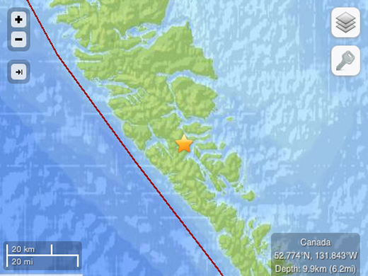
© U.S. Geological SurveyThis photo released by the U.S. Geological Survey shows the area where a 7.7 magnitude earthquake is reported to have struck the north-central coast of British Columbia.
A tsunami warning was issued late Saturday for the coastal areas of northwest British Columbia following a 7.7 magnitude earthquake off the waters near Prince Rupert. It was followed by at least aftershocks.

People in coastal areas were told to move inland to higher ground while residents in low-lying coastal areas were ordered to be on alert for instructions from their local emergency officials after the tsunami warning was issued just before 8 p.m. local time.

The epicentre was reported in coastal waters about 40 kilometres south of Sandspit, B.C. at a depth of 19 kilometres.

Natural Resources Canada issued a statement Saturday: "A major earthquake occurred in the Haida Gwaii region. It was felt across much of north-central B.C., including Haida Gwaii, Prince Rupert, Quesnel and Houston. There have been no reports of damage at this time."

Bizarro Earth

USGS: Earthquake Magnitude 7.7 - South of Masset, Canada

Canada Quake_281012
© USGS
Event Time
2012-10-28 03:04:10 UTC
2012-10-27 20:04:10 UTC-07:00 at epicenter

Location
52.769°N 131.927°W depth=17.5km (10.9mi)

Nearby Cities
139km (86mi) S of Masset, Canada
202km (126mi) SSW of Prince Rupert, Canada
293km (182mi) SW of Terrace, Canada
556km (345mi) NW of Campbell River, Canada
635km (395mi) SSE of Juneau, Alaska

Technical Details

Attention

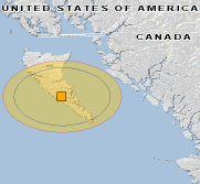
Magnitude 7.7 earthquake in British Columbia, Canada, produces tsunami warnings

sandspit BC earthquake
© GDACS
Yellow alert level for economic losses. Some damage is possible and the impact should be relatively localized. Estimated economic losses are less than 1% of GDP of Canada. Past events with this alert level have required a local or regional level response.

A TSUNAMI WARNING IS NOW IN EFFECT WHICH INCLUDES THE COASTAL AREAS OF BRITISH COLUMBIA AND ALASKA FROM THE NORTH TIP OF VANCOUVER ISLAND BRITISH COLUMBIA TO CAPE DECISION ALASKA/LOCATED 85 MILES SE OF SITKA/...

...THIS MESSAGE IS INFORMATION ONLY FOR COASTAL AREAS OF CALIFORNIA - OREGON - WASHINGTON AND BRITISH COLUMBIA FROM THE CALIFORNIA-MEXICO BORDER TO THE NORTH TIP OF VANCOUVER ISLAND BRITISH COLUMBIA...

..THIS MESSAGE IS INFORMATION ONLY FOR COASTAL AREAS OF ALASKA FROM CAPE DECISION ALASKA/LOCATED 85 MILES SE OF SITKA/ TO ATTU ALASKA...

A TSUNAMI WARNING MEANS... ALL COASTAL RESIDENTS IN THE WARNING AREA WHO ARE NEAR THE BEACH OR IN LOW-LYING REGIONS SHOULD MOVE IMMEDIATELY INLAND TO HIGHER GROUND AND AWAY FROM ALL HARBORS AND INLETS INCLUDING THOSE SHELTERED DIRECTLY FROM THE SEA. THOSE FEELING THE EARTH SHAKE... SEEING UNUSUAL WAVE ACTION... OR THE WATER LEVEL RISING OR RECEDING MAY HAVE ONLY A FEW MINUTES BEFORE THE TSUNAMI ARRIVAL AND SHOULD MOVE IMMEDIATELY. HOMES AND SMALL BUILDINGS ARE NOT DESIGNED TO WITHSTAND TSUNAMI IMPACTS. DO NOT STAY IN THESE STRUCTURES.

ALL RESIDENTS WITHIN THE WARNED AREA SHOULD BE ALERT FOR INSTRUCTIONS BROADCAST FROM THEIR LOCAL CIVIL AUTHORITIES. EARTHQUAKES OF THIS SIZE ARE KNOWN TO GENERATE TSUNAMIS.

AT 804 PM PACIFIC DAYLIGHT TIME ON OCTOBER 27 AN EARTHQUAKE WITH PRELIMINARY MAGNITUDE 7.1 OCCURRED 25 MILES/40 KM SOUTH OF SANDSPIT BRITISH COLUMBIA. EARTHQUAKES OF THIS SIZE ARE KNOWN TO GENERATE TSUNAMIS. IF A TSUNAMI HAS BEEN GENERATED THE WAVES WILL FIRST REACH LANGARA ISLAND BRITISH COLUMBIA AT 916 PM PDT ON OCTOBER 27. ESTIMATED TSUNAMI ARRIVAL TIMES AND MAPS ALONG WITH SAFETY RULES AND OTHER INFORMATION CAN BE FOUND ON THE WEB SITE WCATWC.ARH.NOAA.GOV.