Earthquakes
S


Bizarro Earth

USGS: Earthquake Magnitude 6.5 - Solomon Islands

Solomon Quake_250712
© USGSEarthquake Location
Date-Time
Wednesday, July 25, 2012 at 11:20:27 UTC

Wednesday, July 25, 2012 at 10:20:27 PM at epicenter

Time of Earthquake in other Time Zones

Location
9.721°S, 159.730°E

Depth
22.9 km (14.2 miles)

Region
SOLOMON ISLANDS

Distances
39 km (24 miles) SW of Honiara, Solomon Islands

603 km (374 miles) SE of Arawa, Papua New Guinea

1016 km (631 miles) SE of Kokopo, Papua New Guinea

1023 km (635 miles) E of Alotau, Papua New Guinea

Bizarro Earth

USGS: Earthquake Magnitude 6.4 - Simeulue, Indonesia

Simeulue Quake_250712
© USGSEarthquake Location
Date-Time
Wednesday, July 25, 2012 at 00:27:48 UTC

Wednesday, July 25, 2012 at 07:27:48 AM at epicenter

Location
2.654°N, 96.191°E

Depth
45.9 km (28.5 miles)

Region
SIMEULUE, INDONESIA

Distances
292 km (181 miles) WSW (249°) from Medan, Sumatra, Indonesia 

309 km (192 miles) WNW (290°) from Sibolga, Sumatra, Indonesia

330 km (205 miles) SSE (163°) from Banda Aceh, Sumatra, Indonesia

614 km (382 miles) W (265°) from KUALA LUMPUR, Malaysia

Radar

Eureka Earthquake: Twin Magnitude 5 Quakes Shake Up Northern California

Image
No damage or injuries have been reported after two earthquakes rattled the Northern California coast Friday night.

The U.S. Geological Survey says a magnitude 5.1 quake hit about 78 miles southwest of Eureka at 6:52 p.m. Friday.

Then just after 11 p.m. a magnitude 5.2 earthquake was recorded about 62 miles southwest of Eureka.

A dispatcher at the Eureka Police Department says the quakes were felt in the community, but police had no reports of damage or injuries.

USGS seismologist John Bellini says the quakes took place in an area where there's a lot of seismic activity.

Bizarro Earth

Twin Earthquakes Magnitude 5.1 and 5.2 Rock Eureka, Northern California

Image
© USGS
No damage or injuries have been reported after two earthquakes rattled the Northern California coast Friday night. The U.S. Geological Survey says a magnitude 5.1 quake hit about 78 miles southwest of Eureka at 6:52 p.m. Friday. Then just after 11 p.m. a magnitude 5.2 earthquake was recorded about 62 miles southwest of Eureka.

A dispatcher at the Eureka Police Department says the quakes were felt in the community, but police had no reports of damage or injuries. USGS seismologist John Bellini says the quakes took place in an area where there's a lot of seismic activity.

Radar

Magnitude 4.5 earthquake shakes Victoria, Australia

Image
A magnitude 4.5 earthquake has struck Victoria this evening.

The quake struck in Moe, 117km east south east of Melbourne, at 7.11pm.

A number of Twitter users across Victoria have reported feeling tremors but there have been no reports of damage so far.

A seismologist with Geoscience Australia, Jonathan Bathgate, said the quake felt this evening was an aftershock from the 5.4 earthquake that struck 16km southwest of Moe last month.

"There have been in excess of 200 aftershocks since the June 19 earthquake," he said.

"This one is the largest recorded."

The scientist added that the aftershocks could conceivably carry on for a number of weeks.

Members of the public have been urged not to dial triple zero unless there is an emergency.
Bizarro Earth

USGS: Earthquake Magnitude 6.0 - Kuril Islands

Kuril Islands Quake_200712
© USGSEarthquake Location
Date-Time
Friday, July 20, 2012 at 06:10:25 UTC

Friday, July 20, 2012 at 06:10:25 PM at epicenter

Time of Earthquake in other Time Zones

Location
49.418°N, 155.935°E

Depth
22.7 km (14.1 miles)

Region
KURIL ISLANDS

Distances
137 km (85 miles) S of Severo-Kuril'sk, Russia

424 km (263 miles) SSW of Vilyuchinsk, Russia

442 km (274 miles) SSW of Petropavlovsk-Kamchatskiy, Russia

449 km (278 miles) SSW of Yelizovo, Russia

Bizarro Earth

4.6 magnitude tremor creates panic in Bulgarian capital

Image
© USGS
The relatively strong tremor that threw into panic people in Bulgaria's capital Sofia and nearby Pernik is an aftershock of the 5.8-magnitude quake at the end of May, according to experts.

"What we experienced on Saturday is an aftershock of the earthquake of May 22 this year and has the same epicenter," Professor Nikolay Miloshev, director of the National Institute of Geography, Geophysics and Geodesy, Sofia, explained.

In his words it is not unusual that today's earthquake is related to the May tremor because it was very strong and even then seismologists predicted aftershocks may continue for months.

Saturday's earthquake was estimated as 4.5 on the Richter scale by the European Mediterranean Seismological Centre and as 4.2 on the Richter scale by the Geophysical Institute at the Bulgarian Academy of Sciences (BAS).

Bizarro Earth

5.8 Magnitude Earthquake in Afghanistan, tremors felt in Punjab, Kashmir

Image
© Unknown
A magnitude 5.8 earthquake struck northern India on Thursday evening. Tremors were felt in parts of Punjab and Jammu and Kashmir reportedly. The epicentre of the quake was in Hindukush region.

Press Trust of India (PTI) reported that the powerful earthquake also jolted parts of Punjab and Khyber-Pakhtunkhwa provinces of Pakistan though there were no reports of casualties or damage to property.

The tremor, which lasted about five seconds, occurred at about 7 pm and was followed by powerful aftershocks. It was felt in Islamabad, Lahore and other parts of Punjab, Peshawar and across Khyber-Pakhtunkhwa.

Bizarro Earth

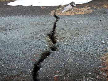
Earthquake Left 20-Meter Crack in Mount Fuji

Image
© KYODOOpening up: In a photo taken in March 2011, a crack can be seen near a shrine at the Fifth Station of Mount Fuji. Experts say it is unlikely to be a sign of an impending eruption or any other abnormality.
Kofu, Yamanashi Pref. - A 20-meter-long crack was found halfway up Mount Fuji in Yamanashi Prefecture after a 6.4-magnitude earthquake hit on March 15, 2011, centered around eastern Shizuoka Prefecture, local authorities revealed Tuesday.

They ruled out the possibility of an eruption.

"No abnormalities have been observed regarding Mount Fuji and the mountain shows no signs of an eruption," an official at the Meteorological Agency said, indicating the crack was caused not by volcanic activity but by the temblor.

Bizarro Earth

USGS: Earthquake Magnitude 5.6 - Eastern Mediterranean Sea

Image
© USGS
Date-Time
Monday, July 09, 2012 at 13:55:00 UTC
Monday, July 09, 2012 at 04:55:00 PM at epicenterTime of Earthquake in other Time Zones

Location
35.623°N, 28.925°E Depth
56.5 km (35.1 miles)

Region

EASTERN MEDITERRANEAN SEA Distances
83 km (51 miles) SSW of Kalkan, Turkey
111 km (68 miles) SE of Rodos, Greece
112 km (69 miles) S of Fethiye, Turkey
112 km (69 miles) SE of Trianta, Greece