Earthquakes
S


Bizarro Earth

Bolivia: Earthquake Magnitude 6.6 - Beni

Image
© USGS
Date-Time:
Tuesday, November 22, 2011 at 18:48:15 UTC

Tuesday, November 22, 2011 at 02:48:15 PM at epicenter

Time of Earthquake in other Time Zones

Location:
15.345°S, 65.110°W

Depth:
533.3 km (331.4 miles)

Region:
BENI, BOLIVIA

Distances:
60 km (37 miles) SSW of Trinidad, Bolivia

251 km (155 miles) NNE of Cochabamba, Bolivia

342 km (212 miles) NW of Santa Cruz, Bolivia

350 km (217 miles) ENE of LA PAZ, Bolivia

Bizarro Earth

Earthquake Rocks Assam, Manipur and Nagaland

Earthquake_211111
© The Times of IndiaAn earthquake measuring 5.9 on the Richter scale rocked India's northeast, Myanmar and Bangladesh on Monday, triggering panic among people.
Guwahati: An earthquake measuring 5.9 on the Richter scale rocked India's northeast, Myanmar and Bangladesh on Monday, triggering panic among people.

The tremor was felt at 8.47am in most parts of Assam, Nagaland, and Manipur, besides in Bangladesh and Myanmar.

The epicentre was located at 24.947°N, 95.226°E in Myanmar, about 130 km east of Manipur capital Imphal, the website of US Geological Survey said.

Seven northeastern states - Assam, Meghalaya, Mizoram, Tripura, Nagaland, Arunachal Pradesh and Manipur - are considered by seismologists to be the sixth most earthquake-prone belt in the world.

The region experienced one of the worst earthquakes, measuring 8.7 on the Richter scale, in 1897, that claimed the lives of over 1,600 people.

In September, more than 50 people died after a killer quake measuring 6.8 on the Richter scale shook the region.

Bizarro Earth

India: Tremors Cause Cracks in Kerala Dam

Image
© jamewils.blogspot.com
Small cracks appeared at least at three points in the 115-year-old Mullaperiyar dam in Kerala's Idukki district following two minor tremors that occurred early on Friday.

The tremors and cracks have created panic among the people in River Periyar's downstream areas. The district has more than a dozen large and medium-sized dams including Asia's largest arch dam, Idukki.

Officials of the Kerala Water Resources Department said the cracks had appeared in Block 17 and the joint of Block 17 and 18 following the tremors. The tremors also caused water seepage through the cracks from the Mullaperiyar reservoir, situated on the Kerala-Tamil Nadu border. Officials said the cracks were no serious enough to cause panic.

Bizarro Earth

New Zealand - Earthquake Magnitude 6.0

NZ_181111
© USGSEarthquake Location
Date-Time
Friday, November 18, 2011 at 07:51:27 UTC

Friday, November 18, 2011 at 07:51:27 PM at epicenter

Time of Earthquake in other Time Zones

Location
37.558°S, 179.311°E

Depth
26.8 km (16.7 miles)

Region
OFF EAST COAST OF THE NORTH ISLAND, N.Z.

Distances
158 km (98 miles) NE of Gisborne, New Zealand

269 km (167 miles) ENE of Rotorua, New Zealand

405 km (251 miles) ESE of Auckland, New Zealand

561 km (348 miles) NE of WELLINGTON, New Zealand

Bizarro Earth

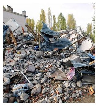
Turkey: Earthquake Magnitude 5.2 - Near Van

Image
© USGS
Date-Time:
Monday, November 14, 2011 at 22:08:15 UTC
Tuesday, November 15, 2011 at 12:08:15 AM at epicenter

Time of Earthquake in other Time Zones

Location:
38.664°N, 43.099°E

Depth:
10 km (6.2 miles)

Region:
EASTERN TURKEY

Distances:
30 km (18 miles) NW of Van, Turkey

117 km (72 miles) S of Agri (Karakose), Turkey

133 km (82 miles) NNW of Hakkari, Turkey

896 km (556 miles) E of ANKARA, Turkey

Bizarro Earth

US: Earthquake Magnitude 4.6 - Washington

Image
© USGS
Date-Time:
Friday, November 18, 2011 at 13:09:00 UTC
Friday, November 18, 2011 at 05:09:00 AM at epicenter

Location:
48.469°N, 119.607°W

Depth:
11.9 km (7.4 miles) set by location program

Region:
WASHINGTON

Distances:
8 km (5 miles) WSW (243°) from Riverside, WA

9 km (6 miles) NW (317°) from Omak, WA

12 km (7 miles) N (350°) from Okanogan, WA

186 km (115 miles) WNW (299°) from Spokane, WA

223 km (139 miles) ENE (64°) from Seattle, WA

Bizarro Earth

New Zealand: 2 Earthquakes Magnitude 5.7 and 5.2 - Off Coast

Image
© USGS
Date-Time:
Friday, November 18, 2011 at 04:34:07 UTC
Friday, November 18, 2011 at 04:34:07 PM at epicenter

Time of Earthquake in other Time Zones

Location:
37.586°S, 179.292°E

Depth:
20.1 km (12.5 miles)

Region:
OFF EAST COAST OF THE NORTH ISLAND, N.Z.

Distances:
163 km (101 miles) NE of Gisborne, New Zealand

274 km (170 miles) ENE of Rotorua, New Zealand

409 km (254 miles) ESE of Auckland, New Zealand

565 km (351 miles) NE of WELLINGTON, New Zealand

Bizarro Earth

Guatemala: 2 back-to-back Earthquakes hit within minutes of each other - 5.1 and 5.0 magnitude

Image
© USGS
Date-Time:
Thursday, November 17, 2011 at 13:31:11 UTC

Thursday, November 17, 2011 at 07:31:11 AM at epicenter

Time of Earthquake in other Time Zones

Location:
14.729°N, 91.858°W

Depth:
96.6 km (60.0 miles)

Region:
GUATEMALA

Distances:
38 km (23 miles) WSW of Quetzaltenango, Guatemala

47 km (29 miles) ESE of Tapachula, Chiapas, Mexico

144 km (89 miles) W of GUATEMALA, Guatemala

935 km (580 miles) ESE of MEXICO CITY, D.F., Mexico

Bizarro Earth

5.7 Magnitude Earthquake Rattles Coast of Ecuador

Ecuador earthquake map 11.17.11
© USGS
A 5.7 magnitude earthquake struck off the coast of Ecuador at 1:57 UTC. The depth of the earthquake was 29.8 km (18.5 miles) SW of Manta and 380 km (236 miles) WSW of the capital QUITO, Ecuador. At the end of October, a 4.0 magnitude earthquake near Quito caused landslides and left cracks in some homes. Buildings were shaken but there have been no reports yet issued of damages. Ecuador sits in the Nazca tectonic plate which creates adjacent stress with the neighboring Caribbean Plate.

Radar

Strong Magnitude 6.2 Earthquake Hit Eastern Indonesian Province of Papua, Causing Panic Among Residents

Earthquake
© redOrbit
A strong earthquake hit Indonesia's eastern province of Papua on Wednesday, causing panic among residents, but there were no immediate reports of damage or casualties.

The earthquake, with a preliminary magnitude of 6.2, struck at 8:42 a.m. local time Wednesday (11:42 p.m. GMT Tuesday), said Indonesia's Meteorology, Climatology and Geophysics Agency.

The agency said the quake was centered about 34 kilometers (21 miles) southwest of the mountainous town of Oksibil at a depth of 57 kilometers (35 miles).

It shocked residents in Oksibil, which is located south of Papua's provincial capital, Jayapura.