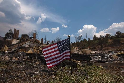
© Reuters'Damn you al-qaeda!' An American flag waves in front of a house leveled by the Waldo Canyon fire in the Mountain Shadows community in Colorado Springs, Colorado, 2 July 2012
Over the past 18 months, we've been growing increasingly concerned for the future of all life on planet earth. Sure, the signs that things have been going 'south' have been there for some time, but our concern began in earnest at the very beginning of 2011, when masses of birds began to
fall dead from the sky around the world. The phenomenon continued for several months, and birds around the world are
still dying for officially unknown reasons. None of the dead birds showed any sign of disease, but in several incidents birds were found to have 'external injuries' like they had been "hit by some kind of blunt instrument". All sorts of explanations for the deaths were offered (like fireworks or birds colliding with each other) including the predictable
attempts by 'science experts' to downplay any significance to the bizarre deaths. But among the flurry of speculation, one report stood out.
NewsChannel5 Chief Meteorologist Mark Johnson decided to take a look at the the Doppler radar images from Beebe, Arkansas from the night when many red-winged blackbirds had fallen dead to the ground, and he discovered
something interesting.
"There it was. This huge plume of turbulence over the Beebe birds just as they began their frenzied flight," Johnson said.
The turbulence appears above the birds between about 7,000 and 12,000 feet. Johnson realized there are only a few possible explanations for this phenomena.
Having homed in on the probable cause, Johnson then introduced some nonsense:
"Birds don't fly that high, and he quickly ruled out military action, a sonic boom, meteor shower or alien invasion."
While we can understand why Johnson ruled out military action or a sonic boom (there were no flights over the area at the time), Johnson never explained why he ruled out a "meteor shower", although we
can understand the inclusion of "alien invasion" - to ridicule by association the idea of a "meteor shower" or other meteorite-related phenomenon.
Johnson then went on to say:
"Something in the atmosphere, something mysterious, occurred over Beebe, Arkansas that night... And I believe it was part of what caused those birds to fly and then die."
Indeed, but with the answer staring him in the face, Johnson lost the plot completely:
Johnson's research captured an unseen temperature reversal just above the birds' roosting area at about 1,500 feet above the ground. This temperature "inversion" acted like a megaphone, amplifying all the noises that occurred in Beebe at that time. As the fireworks exploded, the sound was amplified by the inversion and became much louder than normal. This appears to have startled the birds so much that they burst into flight, running into each other, and nearby buildings. Thousands of the now-disoriented birds then crashed to the ground, dying from blunt force trauma.
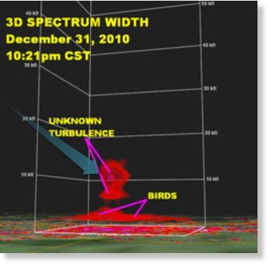
The Doppler radar image used by Johnson to explain the bird deaths. We have added the blue-green arrow to illustrate the trajectory of a meteor reaching that altitude before exploding in the lower atmosphere.
Temperature reversal? At 1,500 feet? But previously Johnson stated that the 'turbulence' occurred between 7,000 and 12,000 feet. He even produced a graph of the Doppler radar images that shows this. While temperature inversion does occur and can amplify sound, when birds are startled by noise they don't generally fly into each other and buildings in large numbers. What's most likely, is that the bird deaths of January 2011 (and later) were caused by an overhead meteorite or comet fragment (MoCF) explosion, with either the actual shock wave killing the birds (through blunt force trauma) or associated electrical effects 'frying' their 'circuits'.
This electrical effect can also explain the massive fish die-offs around the same time. Consider
this report, just in today, about two children being mysteriously electrocuted to death as they swam in a lake in Missouri on 4th July. The thousands of dead fish found upstream from Beebe on New Year's Eve 2010 could well have had their circuits fried because of significant electrical discharge that accompanied the overhead MoCF airburst. Now check out this Tunguska
blast simulation by Sandia lab. An incoming bolide exploding overhead would knock the wind out of anything within a radius relative to the extent of its blast. It would probably
knock airplanes out of the sky too - more on that below.
