Earthquakes
S


Bizarro Earth

Russian earthquake could be deepest ever

Sea of Okhotsk Quake
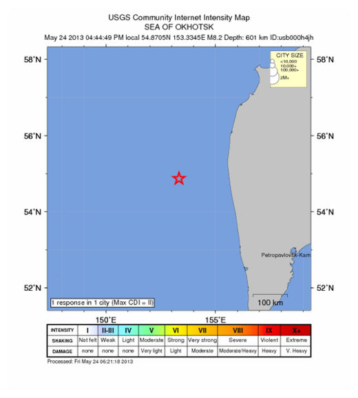
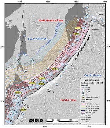
© USGSRecent earthquakes near the Sea of Okhotsk in Russia, including one of the deepest ever recorded.
The massive, magnitude-8.3 temblor that struck today (May 24) near Russia's Kamchatka Peninsula could turn out be the deepest earthquake ever recorded.

At 378 miles (609 kilometers) below the seafloor, the quake could best the previous record set in Bolivia, in 1994. The initial depth may be revised as scientists collect more data. The Bolivian quake was a magnitude-8.2, and 392 miles deep (631 km), Nature News reported.

Why so deep? The Sea of Okhotsk sits above a subduction zone, where the Pacific Plate dives beneath the North America Plate. (Though some scientists think there is also a microplate, a small tectonic plate, beneath the sea.) The northwest Pacific crust is some of oldest, coldest oceanic crust subducting on Earth. It's also quickly rolling into the subduction zone, like a speedy conveyor belt, so the cold crust reaches deep into Earth's mantle before warming up.

Bizarro Earth

USGS: Earthquake Magnitude 6.8 - Sea of Okhotsk (Aftershock)

Oshotsk quake_240513
© USGS
Event Time
2013-05-24 14:56:31 UTC
2013-05-25 00:56:31 UTC+10:00 at epicenter

Location
52.222°N 151.515°E depth=623.0km (387.1mi)

Nearby Cities
353km (219mi) WNW of Ozernovskiy, Russia
473km (294mi) W of Vilyuchinsk, Russia
476km (296mi) W of Yelizovo, Russia
491km (305mi) W of Petropavlovsk-Kamchatskiy, Russia
2061km (1281mi) NNE of Tokyo, Japan
Technical Details

Bizarro Earth

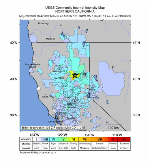
22 Aftershocks shake up northern California

At least 22 aftershocks have struck following an earthquake in far northeastern California that was felt as far away as San Francisco and in two other states.

There have been no reports of injury or serious damage.

Officials said the magnitude-5.7 quake broke dishes and shook mirrors when it hit at 8:47 p.m. Thursday.

The U.S. Geological Survey's National Earthquake Center said it was centered near Greenville, about 25 miles southwest of Susanville. It was followed by multiple aftershocks, including a magnitude 4.9 temblor that struck early Friday morning.

Pacific Gas & Electric said about 660 customers lost power on the southwestern edge of Lake Almanor at about 9:39 p.m. Thursday. The company did not immediately clarify whether the outage was due to the quake.

Cloud Grey

Tremors felt in Moscow as 8.2 quake rattles Russia's Sakhalin region

Image
© image by @nakedarizonaMuscovites fled their offices after feeling the tremors that followed an earthquake in the Okhotsk Sea, thousands of kilometers away.
Tremors have been felt all across Russia and in Europe, following a major 8.2 earthquake in the Sakhalin region

Panicking Muscovites began calling security services, and some decided to leave their homes.

The residents informed security services of vibration and tremors that caused furniture and kitchen utensils to move.

The magnitude of the tremors felt in Moscow was no higher than 1 on the Richter scale, the Agency of Hydrometeorological and Environmental monitoring indicated.

Bizarro Earth

Aftershocks shake Northern California after 5.7 earthquake

NOCAL Quake_240513
© USGS
More than a dozen aftershocks were reported Thursday night following a 5.7 earthquake about 150 miles northeast of Sacramento, officials said.

The initial quake hit about 8:47 p.m.; its epicenter was about 27 miles southwest of Susanville and seven miles west northwest of Greenville, according to the U.S. Geological Survey.

People on Twitter told The Times they felt that quake in Sacramento and Lodi, as well as South Reno and on the northwest shore of Lake Tahoe.

Police officials in Susanville and Sacramento said that the quake set off a number of home and car alarms and rattled windows but that there were no immediate reports of damage.

"We got a bunch of alarm calls and a bunch of barking dogs," dispatcher Taylor Richards of the Sacramento Police Department told The Times. "It was a good solid feel here."

Within minutes of the quake, more than 7,000 people reported feeling it on the USGS website.A man in Chico told The Times he felt a slow roll that lasted about 30 seconds.The aftershocks' magnitude ranged up to 3.5, according to the U.S. Geological Survey.

"House shook pretty hard," one man near Truckee told The Times.

Bizarro Earth

USGS: Earthquake Magnitude 8.3 - Sea of Okhotsk

Okhotsk Quake_240513
© USGS
Event Time
2013-05-24 05:44:49 UTC
2013-05-24 15:44:49 UTC+10:00 at epicenter


Location

54.870°N 153.334°E depth=601.8km (373.9mi)

Nearby Cities
359km (223mi) WSW of Esso, Russia
379km (235mi) WNW of Yelizovo, Russia
396km (246mi) NW of Vilyuchinsk, Russia
403km (250mi) WNW of Petropavlovsk-Kamchatskiy, Russia
2375km (1476mi) NNE of Tokyo, Japan

Technical Details

Bizarro Earth

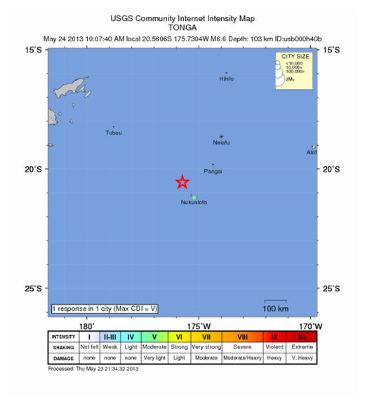
USGS: Earthquake Magnitude 6.6 - NW of Nuku'alofa, Tonga

Tonga Quake2_230513
© USGS
Event Time
2013-05-23 21:07:40 UTC
2013-05-23 09:07:40 UTC-12:00 at epicente

Location
20.561°S 175.730°W depth=103.2km (64.2mi)

Nearby Cities
84km (52mi) NW of Nuku'alofa, Tonga
668km (415mi) ESE of Suva, Fiji
690km (429mi) SE of Lambasa, Fiji
782km (486mi) ESE of Nadi, Fiji
855km (531mi) SSW of Apia, Samoa

Technical Details

Bizarro Earth

Unusual number of earthquakes in Arkansas reported since Monday

Image
An unusual number of earthquakes have been reported in Central Arkansas since Monday. More than a dozen have been reported across Morrilton, Strawberry, and Choctaw.

James Newsom felt the quake. At the time, he didn't know what shook his home."I said what in the world was that," said Newsom.

Scientists say a 3.5 earthquake hit the area. The U.S. Geological Survey says there have been 16 earthquakes, which is a high number.

"It was just boom. It was so quick and shook my windows and made that explosion ya know," said Newsom.

Each quake lasted less than ten seconds.

"Even though we don't have reports of damage or anything or injuries, it's still a pretty good shake," said Scott Ausbrooks of the U.S. Geological Survey.

Bizarro Earth

Earthquakes create global-scale GPS errors

Deformation
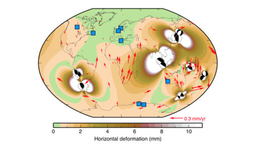
© Paul Tregoning, Journal of Geophysical ResearchDeformation from earthquakes bigger than magnitude 8.0 since 2000. The blue squares are GPS reference sites, and the red arrows are deformation from big earthquakes.
Twelve years of supersized earthquakes have contaminated GPS sites around the world, a new study finds.

The Global Positioning System is a network of satellites and ground stations that provide location information anywhere on Earth. Except for spots in Australia, western Europe and the eastern tip of Canada, every GPS site on the ground underwent small but important shifts since 2000 because of big earthquakes, according to a study published May 6 in the Journal of Geophysical Research: Solid Earth.

The research confirms that great earthquakes, those bigger than magnitude 8.0, can have far-reaching effects on the Earth's crust. And because GPS is critical for everything from calculating satellite orbits to sea level rise to earthquake hazards, scientists can't ignore these tiny zigs and zags, the researchers conclude.

"We have to find a way to deal with it," said Paul Tregoning, lead study author and a geophysicist at Australia National University in Canberra. "The community needs to work out how to find all the offsets, estimate them accurately and get everyone to agree on how to correct them," he told LiveScience.

Tregoning and his colleagues modeled the sudden jolts in Earth's crust from each of the 15 biggest earthquakes since 2000. They discovered that crust thousands of miles away from the faults had moved horizontally by as much as a tenth of an inch (a few millimeters). The model was checked against a few spots around the planet. On average, the earthquakes deformed the crust by a hundredth of an inch every year (0.4 millimeters a year) - about the width of the lead in a mechanical pencil.

"It's quite amazing to us that we can see this and detect this," Tregoning said.

These tiny effects won't make a difference to the GPS in cars or phones, or the tough little units carried by hikers and mountaineers. But scientists who need precise measurements to calculate sea level rise or satellite orbits should be concerned, Tregoning said.
Bizarro Earth

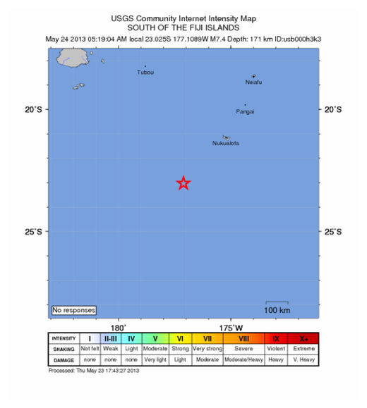
USGS: Earthquake Magnitude 7.4 - SW of Vaini, Tonga

Tonga Quake_230513
© USGS
Event Time
2013-05-23 17:19:04 UTC
2013-05-23 05:19:04 UTC-12:00 at epicenter

Location
23.025°S 177.109°W depth=171.4km (106.5mi)

Nearby Cities
282km (175mi) SW of Vaini, Tonga
287km (178mi) SW of Nuku'alofa, Tonga
712km (442mi) SE of Suva, Fiji
812km (505mi) SE of Nadi, Fiji
818km (508mi) SSE of Lambasa, Fiji

Technical Details