Earthquakes
S


Bizarro Earth

Earth's biggest deep earthquake still a mystery

Sea of Okhotsk Quake
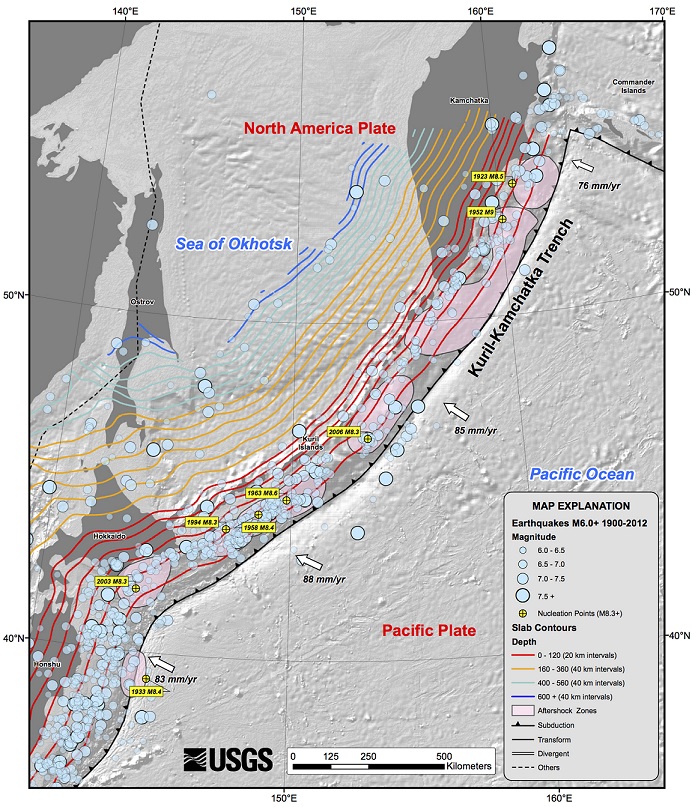
© USGSRecent earthquakes near the Sea of Okhotsk in Russia, including one of the deepest ever recorded.
It's confirmed: The largest deep earthquake ever recorded happened in May off the coast of Russia. But this massive temblor is still a mystery to scientists.

The magnitude-8.3 earthquake occurred on May 24, 2013, in the Sea of Okhotsk, deep within the Earth's mantle. The earthquake, described today (Sept. 19) in the journal Science, is perplexing because seismologists don't understand how massive earthquakes can happen at such depths.

"It's the biggest event we've ever seen," said study co-author Thorne Lay, a seismologist at the University of California, Santa Cruz. "It looks so similar to shallow events, even though it's got 600 kilometers of rock on top of it. It's hard to understand how such an earthquake occurs at all under such huge pressure."

Heart - Black

600 vultures killed by elephant poachers in Namibia

As the illegal poaching of African elephants and rhinos reaches epidemic levels, other species are also suffering catastrophic losses as a direct result of poachers' behavior. A recent incident in July, where a poisoned elephant carcass led to the death of 600 vultures near Namibia's Bwabwata National Park, has highlighted how poachers' use of poison is now one of the primary threats to vulture populations. Poachers poison carcasses to kill vultures, since large flocks may give away the location of poaching activity, attracting the attention of law enforcement officials.

Image
© André Botha.Rueppell's vulture (Gyps rueppellii).
"By poisoning carcasses, poachers hope to eradicate vultures from an area where they operate and thereby escape detection," explains Leo Niskanen, Technical Coordinator, IUCN Conservation Areas and Species Diversity Programme. "The fact that incidents such as these can be linked to the rampant poaching of elephants in Africa is a serious concern. Similar incidents have been recorded in Tanzania, Mozambique, Zimbabwe, Botswana and Zambia in recent years".

African vultures are highly imperiled, and are under pressure from a range of factors, including habitat loss as well as poisonings. Drastic population declines over the last 30 years have resulted in many species being classified as threatened by the IUCN. On average, the number of vultures in West Africa has dropped by 42% during this time, with Rueppell's vulture (Gyps rueppellii) suffering losses of up to 85%.

Bizarro Earth

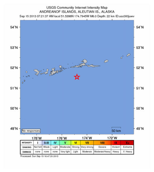
USGS: Earthquake Magnitude 6.1 - 83km SSW of Atka, Alaska

Atka Quake_150913
© USGS
Event Time
2013-09-15 16:21:37 UTC
2013-09-15 04:21:37 UTC-12:00 at epicenter

Location
51.540°N 174.794°W depth=22.8km (14.2mi)

Nearby Cities
83km (52mi) SSW of Atka, Alaska
1537km (955mi) SSE of Anadyr', Russia
1809km (1124mi) E of Petropavlovsk-Kamchatskiy, Russia
1825km (1134mi) E of Yelizovo, Russia
2623km (1630mi) W of Whitehorse, CanadaTechnical Data

Bizarro Earth

Bermuda Triangle earthquake triggered 1817 tsunami

Tsunami
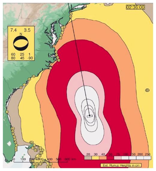
© Susan Hough, USGSA model predicted the tsunami wave height from a Jan. 8, 1817, earthquake offshore South Carolina. The earthquake's magnitude was estimated at 7.4 from newspaper accounts.
A "tidal wave" violently tossed ships docked along the Delaware River south of Philadelphia at about 11 a.m. ET on Jan. 8, 1817, according to newspapers of the time. Turns out, that tidal wave was actually a tsunami, launched by a powerful magnitude-7.4 earthquake that struck at approximately 4:30 a.m. ET near the northern tip of the Bermuda Triangle, a new study finds.

The study links the tsunami to a known Jan. 8, 1817, earthquake. The temblor shook the East Coast from Virginia south to Georgia, where the seismic waves made the State House bell ring several times.

Based on archival accounts of the 1817 shaking, geologists had gauged the quake's size at magnitude 4.8 to magnitude 6. Now, with new geologic detective work and computer modeling of the tsunami, researchers have considerably revised the earthquake's size. A magnitude-7.4 quake releases almost 8,000 times more energy than a magnitude-4.8 earthquake.

The size and location, or epicenter, of the 1817 earthquake has never been pinned down so closely before. U.S. Geological Survey research geophysicist Susan Hough and her colleagues zeroed in on the source from newly uncovered archival records, looking at where the shaking was strongest.

But they weren't sure about the tsunami link: The 11 a.m. arrival time seemed too late for a 4:30 a.m. earthquake. So they created a computer model of the tsunami, testing different locations and magnitudes. The best fit to force a foot-high (30 centimeters) wave up the mouth of Delaware Bay by about 11 a.m. was a magnitude-7.4 earthquake offshore of South Carolina.

"That was the eureka moment," Hough told LiveScience's OurAmazingPlanet. "Darned if that wave doesn't hit the Delaware River and slow way down."
Attention

Major faultlines with the potential to trigger massive tsunamis found off West Coast of New Zealand

earthquake
© File Photo / New Zealand Herald
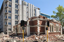
Faultlines capable of causing earthquakes with magnitudes of up to 7.8, with the potential to trigger massive tsunamis, have been found off the northern West Coast.

However, the West Coast Regional Council today moved to reassure the public, saying the Alpine Fault was a far more imminent threat.

The National Institute of Water and Atmospheric Research (Niwa) led the two-year mapping project for the council, which wanted to assess the tsunami risk for coastal communities.

Niwa marine geologist Philip Barnes said while the faults were relatively large and capable of causing fairly severe earthquakes, it was thought they had extremely long recurrence intervals, meaning that large earthquakes would be very infrequent.

Bizarro Earth

USGS: Earthquake Magnitude 6.5 - 6km SW of Pajapita, Guatemala

Image
© USGS
Event Time:
2013-09-07 00:13:30 UTC
2013-09-06 18:13:30 UTC-06:00 at epicenter

Location:
14.668°N 92.075°W depth=67.7km (42.0mi)

Nearby Cities:
6km (4mi) SW of Pajapita, Guatemala
8km (5mi) E of Ciudad Tecun Uman, Guatemala
20km (12mi) NE of Suchiate, Mexico
22km (14mi) W of Coatepeque, Guatemala
168km (104mi) W of Guatemala City, Guatemala

Technical Data

Network

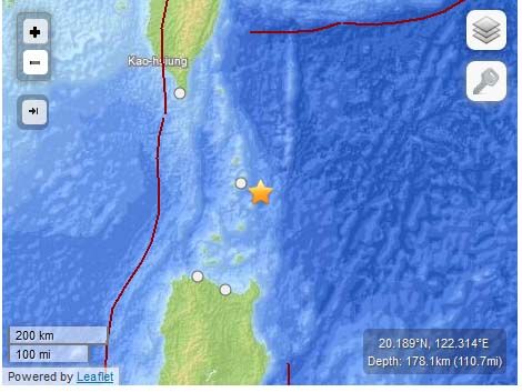
USGS: M6.0 - 43km ESE of Uyugan, Philippines

Earthquake Philipines
© USGS
Event Time
2013-09-06 11:33:53 UTC
2013-09-06 19:33:53 UTC+08:00 at epicenter

Location
20.189°N 122.314°E depth=178.1km (110.6mi)

Nearby Cities

43km (27mi) ESE of Uyugan, Philippines
214km (133mi) NNE of Aparri, Philippines
217km (135mi) NE of Claveria, Philippines
258km (160mi) SE of Hengchun, Taiwan
634km (394mi) NNE of Manila, Philippines

Technical Details

Bell

More fracking headaches as earthquake evidence grows

Earthquake damaged road
© Martin Luff
It looks like more trouble is looming ahead for communities that host fracking operations. Two new studies have linked fracking-related operations to earthquakes in Texas and Ohio, and a recently settled lawsuit in Arkansas indicates that swarms of tiny earthquakes can damage surface structures. Add earthquakes to a list that already includes water contamination and air pollution risks, and it becomes clear that a more effective regulatory platform is needed to protect existing communities from the impacts of fracking.

The Fracking Explosion

Fracking is short for hydrofracturing, a drilling method that releases oil or gas from shale formations by pumping a chemical brine underground. Somewhat ironically, the method was originally developed by federal researchers to aid the geothermal industry.

As an "unconventional" oil and gas drilling method, fracking was not in widespread use in the US until recent years, and regulatory agencies have been scrambling to play catchup as evidence of water and air impacts piles up.

Bizarro Earth

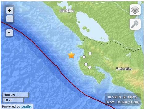
USGS: M6.0 - 50km W of Sardinal, Costa Rica

6.0 Costa Rica Earthquake
© USGS
Event Time
2013-09-05 12:29:15 UTC
2013-09-05 06:29:15 UTC-06:00 at epicenter

Location

10.586°N 86.106°W depth=18.0km (11.2mi)

Nearby Cities
50km (31mi) W of Sardinal, Costa Rica
67km (42mi) WNW of Santa Cruz, Costa Rica
73km (45mi) W of Liberia, Costa Rica
86km (53mi) NW of Nicoya, Costa Rica
171km (106mi) S of Managua, Nicaragua

Technical Details

Bizarro Earth

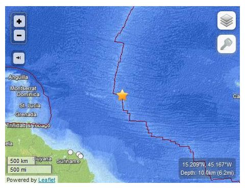
USGS: Earthquake Magnitude 6.0 - Northern Mid-Atlantic Ridge

Mid Atlantic Quake_050913
© USGS
Event Time
2013-09-05 04:01:35 UTC
2013-09-05 01:01:35 UTC-03:00 at epicenter

Location
15.209°N 45.167°W depth=10.0km (6.2mi)

Nearby Cities
1378km (856mi) NNE of Remire-Montjoly, French Guiana
1380km (857mi) NE of Cayenne, French Guiana
1380km (857mi) NE of Kourou, French Guiana
1388km (862mi) NNE of Matoury, French Guiana
1446km (899mi) NE of Saint-Laurent-du-Maroni, French Guiana

Technical Details