Earthquakes
S

Camera

Best of the Web: Photos: Japan Earthquake Aftermath

Three days after a massive earthquake that is now estimated to have registered a 9.0 magnitude, Japanese rescue crews are being joined by foreign aid teams in the search for survivors in the wreckage. Japan's Prime Minister Naoto Kan has called the disaster the nation's worst crisis since World War II, as the incredible scope of the destruction becomes clear and fears mount of a possible nuclear meltdown at a failing power plant. It is still too early for exact numbers, but the estimated death toll may top 10,000 as thousands remain unaccounted for. Gathered here are new images of the destruction and of the search for survivors.

Image
© REUTERS/Mainichi ShimbunA wave approaches Miyako City from the Heigawa estuary in Iwate Prefecture after the magnitude 9.0 earthquake struck the area March 11, 2011. Picture taken March 11, 2011.

X

Japan quake: Toll may cross 10,000 in Miyagi alone

The toll from a magnitude-8.9 earthquake in Japan could exceed 10,000 in the hardest-hit prefecture of Miyagi alone, police said on Sunday, as other officials tried to reassure the public that reactors at two damaged nuclear power plants posed no immediate danger.

"I have no doubt" that the death toll would rise above 10,000 in the prefecture, public broadcaster NHK quoted police chief Takeuchi Naoto as saying.

About 800 deaths had been confirmed so far in Miyagi and other areas in northeastern Japan, which were hit Friday by the quake and a tsunami. No contact could be established with about 10,000 residents of the town of Minamisanriku.

Bizarro Earth

US: Moderate Quake Hits Gulf of California on Saturday Morning

Gulf of California Quake
© The Weather Space
A 5.3-magnitude Earthquake hit the Gulf of California on Saturday morning.

TWS did not receive any reports of damage, however reports of light shaking were received in the city of Los Mochis, Mexico.

The quake hit under 50 miles west of Los Mochis at 7:11 a.m. local time, and struck the very center of the Gulf of California, on the plate boundary.

Sensors indicated the quake was a strike-slip, or side to side motion along the fault-zone.

A 4.7-magnitude aftershock was registered in the same location as the larger quake several hours later.

The USGS data for this quake can be viewed here.

Bizarro Earth

Quake Moved Japan by 8 feet: USGS

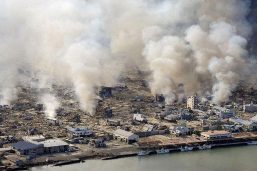
Yamada
© Agence France-PresseWhite smokes rises into the air in the badly damaged town of Yamada.
Washington - Japan's recent massive earthquake, one of the largest ever recorded, appears to have moved the island by about eight feet (2.4 meters), the US Geological Survey said.

"That's a reasonable number," USGS seismologist Paul Earle told AFP. "Eight feet, that's certainly going to be in the ballpark."

Friday's 8.9 magnitude quake unleashed a terrifying tsunami that engulfed towns and cities on Japan's northeastern coast, destroying everything in its path in what Prime Minister Naoto Kan said was an "unprecedented national disaster."

The quake and its tectonic shift resulted from "thrust faulting" along the boundary of the Pacific and North America plates, according to the USGS.

The Pacific plate pushes under a far western wedge of the North America plate at the rate of about 3.3 inches (83 millimeters) per year, but a colossal earthquake can provide enough of a jolt to dramatically move the plates, with catastrophic consequences.

"With an earthquake this large, you can get these huge ground shifts," Earle said. "On the actual fault you can get 20 meters (65 feet) of relative movement, on the two sides of the fault."
Hourglass

Japan quake causes day to get a wee bit shorter

You won't notice it, but the day just got a tiny bit shorter because of Friday's giant earthquake off the coast of Japan.

earth1-space-view
© Unknown
NASA geophysicist Richard Gross calculated that Earth's rotation sped up by 1.6 microseconds. That's because of the shift in Earth's mass caused by the 8.9-magnitude earthquake. A microsecond is one-millionth of a second.

Camera

Images - Japanese Earthquake and Tsunami

A massive 8.9-magnitude quake hit northeast Japan on Friday, causing dozens of deaths, more than 80 fires, and a 10-meter (33-ft) tsunami along parts of the country's coastline. Homes were swept away and damage is extensive.

Below is a stunning collection of photographs which show some of the devastation in Japan:

Image
© REUTERS/KYODOBuildings burn near Sendai Airport, northeastern Japan in the aftermath of the record 8.9 magnitude earthquake March 11, 2011.
Image
© Reuters/KyodoPeople take shelter as a ceiling collapses in a bookstore in the city of Sendai.

Camera

NASA Satellite Photos Show Devastation From Japan Quake and Tsunami

Image
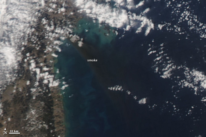
© MODIS Rapid Response Team/NASA GSFCThis image from NASA's Aqua satellite shows a major fire raging near the coastal city of Sendai in northeastern Japan after the massive 8.9-magnitude earthquake that struck on March 11, 2011. This image was taken by Aqua's MODIS instrument on March 12.
NASA satellites have snapped new pictures of the devastating floods and fires in Japan from the deadly earthquake and tsunami that struck the country on Friday (March 11).

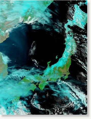
Photos from NASA's Earth-watching Terra and Aqua satellites paint a stark picture from above of the damage by the massive 8.9-magnitude earthquake and the subsequent tsunami it spawned. They show Japan's northern region, particularly the city of Sendai - which is visible inundated by floodwaters and fires in the satellite views.

The images were taken today (March 12) - one day after the natural disaster as part of NASA's MODIS Rapid Response system, which uses satellites to provide near real-time images of Earth's landmasses every day. The system can snap photos of Japan twice a day, NASA officials said. [Japan Earthquake and Tsunami in Pictures]

Better Earth

Japan Quake Shifted Earth 4 Inches on Its Axis

Image
© ReutersNASA's Terra satellite's first view of northeastern Japan flooding following the earthquake and tsunami in northeastern Japan
The powerful earthquake that unleashed a devastating tsunami Friday appears to have moved the main island of Japan by 8 feet (2.4 meters) and shifted the Earth on its axis.

"At this point, we know that one GPS station moved (8 feet), and we have seen a map from GSI (Geospatial Information Authority) in Japan showing the pattern of shift over a large area is consistent with about that much shift of the land mass," said Kenneth Hudnut, a geophysicist with the U.S. Geological Survey (USGS).

Attention

After quake, 10,000 missing in Japan

Image
© Unknown
Following the massive earthquake in northern Japan, nearly 10,000 people are unaccounted for in the port town of Minamisanriku in Miyagi Prefecture.

The figure is more than half of the town's population of 17,000, Japan Broadcasting Corporation NHK announced on Saturday.

On Friday, an 8.9-magnitude earthquake, off the northeastern coast of Japan's main island, unleashed a 23-foot (7-meter) tsunami and was followed by more than 50 aftershocks for hours.

Bizarro Earth

Japan pre-dawn quakes cause landslides in Niigata

Image
© UnknownThe tarmac and surrounding area of Sendai Airport is covered with water after a tsunami.
Tokyo - A strong 6.7-magnitude earthquake felt in Tokyo hit Japan's mountainous Niigata prefecture and caused landslides and avalanches at 4:00 am Saturday (1900 GMT Friday).

Kyodo News said there were no immediate reports of casualties and no fresh tsunami alert was issued after the quake, which was followed by an almost equally strong quake in the same area half an hour later.

The quakes struck in the west of the main Honshu island, on the Sea of Japan coast and far from the offshore Pacific Ocean tremor that triggered a mammoth tsunami Friday that is feared to have killed more than 1,000 people.

The focus of both predawn quakes was in central Niigata.

The US Geological Survey put the strength at 6.2 and said it hit at a depth of only one kilometre (about half a mile).

Police said they had received reports of a landslide and avalanche in Tokamachi and another avalanche in Tsunan town, Kyodo reported.

The news agency also said wooden buildings including a town hall and a garage had reportedly been destroyed and some highways cracked in the village of Sakae in Nagano prefecture.

The first quake in the inland region struck at 4:00 am Saturday (1900 GMT Friday). The focus was in central Niigata but it also shook neighbouring Nagano, and a third quake later followed in the region.