Earthquakes
S


Bad Guys

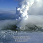
Volcano erupts in Iceland, spurs 50 quakes

White plume shoots 18,000 feet above the glacier that sits over the volcano
Image
© Photographers DirectGrimsvotn volcano
Reykjavik, Iceland - Iceland's most active volcano erupted Saturday, with a white plume shooting 18,000 feet into the air, scientists said.

The eruption was followed by around 50 small earthquakes, the largest of which measured 3.7 on the Richter Scale, according to Iceland's meteorological office.

There was a similar eruption at the same volcano in 2004.

Scientists don't believe this eruption will lead to air travel chaos like that caused by ash from the Eyjafjallajokul volcano in April 2010.

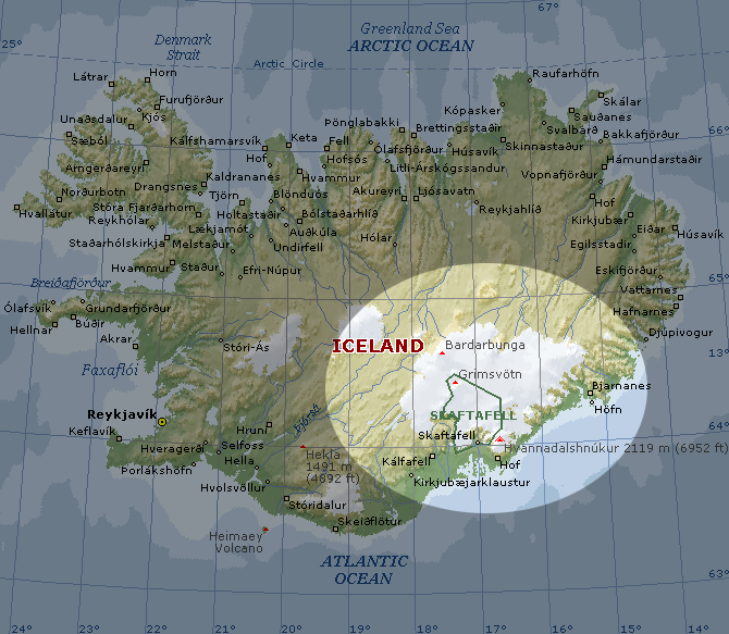
The Grimsvotn volcano is located underneath the Vatnajokull glacier in southeast Iceland.

Sparsely populated Iceland is one of the world's most volcanically active countries and eruptions are frequent.

They often cause local flooding from melting glacier ice, but rarely cause deaths.

Last year's Eyjafjallajokul eruption left millions of air travelers stranded after winds pushed the ash cloud toward some of the world's busiest airspace and led most northern European countries to ground all planes for five days.

In November, melted glacial ice began pouring from, signaling a possible eruption. That was a false alarm but scientists have been monitoring the volcano closely ever since.
Image
© UnknownGrimsvotn Volcano Area - Iceland.

Bizarro Earth

Australia: Earthquake Magnitude 4.6 - Western Australia

Image
© USGS
Date-Time:
Friday, May 20, 2011 at 20:03:27 UTC

Saturday, May 21, 2011 at 04:03:27 AM at epicenter

Location:
23.412°S, 119.324°E

Depth:
12 km (7.5 miles)

Region:
WESTERN AUSTRALIA

Distances:
1008 km (627 miles) NNE (21°) from Perth, Australia

1779 km (1105 miles) SSW (201°) from DILI, East Timor

Bizarro Earth

Turkey: Earthquake Magnitude 6.0 - Western Turkey

Image
© USGS
Date-Time:
Thursday, May 19, 2011 at 20:15:23 UTC

Thursday, May 19, 2011 at 11:15:23 PM at epicenter

Time of Earthquake in other Time Zones

Location:
39.115°N, 29.124°E

Depth:
4.6 km (2.9 miles) (poorly constrained)

Region:
WESTERN TURKEY

Distances:
53 km (32 miles) NNW of Usak, Turkey

82 km (50 miles) WSW of Kutahya, Turkey

120 km (74 miles) S of Bursa, Turkey

332 km (206 miles) WSW of ANKARA, Turkey

Bizarro Earth

Frequency of Tremors on the Rise in Guerrero

Acapulco,- So far in the month of May, 60 tremors have been registered in Guerrero, mostly in the Richter range of 3 or 4. Monday afternoon a tremor of 4.3 was felt and an earlier one of 5.5 was registered on May 5 with the same epicenter, in the municipality of Ometepec, in the Costa Chica, to the east and south of Acapulco. More than one-third of the tremors taking place in this month in Guerrero have had their origin in the Costa Chica.

Five tremor epicenters have occurred within the municipality of Acapulco since May 1, all of them between 3 and 4 on the Richter scale. The tremors felt in Guerrero in the first two weeks of May is double the number registered for the same period last year.

Info

Philippines: 144 quakes at Bulusan in last 24 hours

Alert level 1 remains at Bulusan Volcano in Sorsogon after state volcanologists noted a significant rise in seismic activity in the area, recording 144 volcanic quakes there in the last 24 hours.

The Philippine Institute of Volcanology and Seismology (Phivolcs) said 80 of these quakes were recorded in a seven-hour period on Monday, from 5:00 a.m. to noon.

Bizarro Earth

Papua New Guinea - Earthquake Magnitude 6.5 - Bougainville Region

Papua Quake_150511
© USGSEarthquake Location
Date-Time:
Sunday, May 15, 2011 at 18:37:10 UTC

Monday, May 16, 2011 at 04:37:10 AM at epicenter

Location:
6.157°S, 154.446°E

Depth:
43.2 km (26.8 miles)

Region:
BOUGAINVILLE REGION, PAPUA NEW GUINEA

Distances:
122 km (76 miles) W (273°) from Arawa, Bougainville, PNG

248 km (154 miles) WNW (283°) from Chirovanga, Solomon Islands

331 km (206 miles) SE (131°) from Rabaul, New Britain, PNG

709 km (441 miles) WNW (301°) from HONIARA, Solomon Islands

825 km (513 miles) E (86°) from Lae, New Guinea, PNG

Bizarro Earth

Central Mid Atlantic Ridge - Earthquake Magnitude 6.0

Atlantic Quake_150511
© USGSEarthquake Location
Date-Time:
Sunday, May 15, 2011 at 13:08:12 UTC

Sunday, May 15, 2011 at 11:08:12 AM at epicenter

Location:
0.461°N, 25.601°W

Depth:
10 km (6.2 miles) set by location program

Region:
CENTRAL MID-ATLANTIC RIDGE

Distances:
1276 km (793 miles) ENE (57°) from Natal, Brazil

1624 km (1009 miles) S (188°) from PRAIA, Cape Verde

Radar

New Zealand: Aftershocks Continue Daily after Christchurch Earthquake 2011

Image
© Debbie RoomeThe Back View of Buildings on High St after Christchurch Earthquake 2011
A series of aftershocks woke a number of Christchurch residents in the early hours of Sunday 15th May, 2011.

Aftershocks continue to rattle Christchurch on a daily basis with 7 occurring between 4pm on the 14th May and 3pm on the 15th May. Some of these shocks relate to the 7.1 September 2010 earthquake and others to the 6.3 February 2011 earthquake.

Aftershocks on the 15th May 2011

According to the Geonet website, Christchurch was shaken by 3 large aftershocks between 1am and 3am on Sunday 15th May. The first was a 4.0 magnitude centered near Springston. This aftershock was close to the area of the September 2010 earthquake. The second and third aftershocks measured 4.6 and 4.0 and both were in the ocean off the East Coast. They were centered just over 20 kilometers from Cathedral Square in Christchurch central.

These aftershocks disturbed many people's sleep and Facebook comments reported that frightened children ran and climbed into bed with parents. Other people described the tremors as a good shake and shudder. One person said their windows rattled and there was also a comment about chairs on wheels moving.

Bizarro Earth

Costa Rica - Earthquake Magnitude 6.0

Costa Rica Quake_130511
© USGSEarth Location
Date-Time:
Friday, May 13, 2011 at 22:47:55 UTC

Friday, May 13, 2011 at 04:47:55 PM at epicenter

Time of Earthquake in other Time Zones

Location:
10.105°N, 84.261°W

Depth:
70 km (43.5 miles)

Region:
COSTA RICA

Distances:
25 km (16 miles) WNW (303°) from SAN JOSE, Costa Rica

126 km (78 miles) SSE (153°) from San Carlos, Nicaragua

137 km (85 miles) W (275°) from Limon, Costa Rica

Bad Guys

Expert says eruption of Etna volcano linked to earthquake in Spain

Image
© Unknown
Rome - The eruption of the Etna volcano in southern Italy early Thursday is connected to the earthquakes that rocked the Spanish region of Murcia, killing 12 people and injuring more than 170 others, a seismology expert said Thursday.

"We are currently witnessing an intense seismic activity in the entire Mediterranean area from Spain all the way to Malta which has a certain impact on regional volcanoes," said Domenico Patane, director of the Sicily office of Italy s National Geophysics Institute.

Patane said volcanoes are like windows from where underground magma surfaces and it's normal that they respond to earthquakes occurring in a geographic proximity.

"The Spanish eastern coast hit by the quake, after all, lies close to Italy, in the Mediterranean. Both Spain and Sicily are on the same earth plate," he said.

The earthquakes in Spain on Wednesday, which could be felt in Madrid, reportedly had their epicenter near the towns of Lorca and Totana in the Murcia region. The initial tremor of 4.4 magnitude was followed by a quake of about 5.2 magnitude.