Earth ChangesS


Cloud Lightning

US: Storm Leaves Thousands without Power in Chattanooga, Tennessee

In about 30 minutes, Monday's storm surged across Hamilton County, leaving behind about 37,000 homes without power. Chattanooga's Public Works Department was called to remove 48 downed trees and the back half of a downtown building collapsed.

By about 8 p.m. Monday, EPB officials reported that 20,000 homes were without power.

Cloud Lightning

US: Damaging Winds, Heavy Rain Pound Midwest, Move into Southeast

Midwest storm damage
© CNNSevere weather in the Chattanooga area of Tennessee left buildings damaged on Monday.
Severe weather descended on the Southeast Monday, killing at least one person, reducing homes to rubble and leaving drivers stranded in flooded streets as the storm system moved northward up the East Coast.

One man was killed in Tennessee after being pinned by a trailer that was lifted by strong winds, said Sgt. Chris Guess, a spokesman for the Franklin County Sheriff's Office. A woman in the home was taken to a hospital with back and leg injuries, he said.

The winds also downed trees and caused significant damage in the northern part of the county, northwest of Chattanooga, Guess said, adding that the sheriff's office could not yet confirm whether the destruction was due to a tornado.

Cloud Lightning

US: Storm brings mix of heavy rain, high wind, and snow to Northwest Oregon


The National Weather Service issued a Flood Advisory, a Wind Advisory and a Winter Weather Advisory for the Portland and Vancouver Metro areas through 2 p.m., Monday as a powerful storm created heavy rains and winds that transitioned into snow above 500 feet.

The rain was mixed with snow in some parts of the metro area as low as 500 feet - including the West Hills, Gresham and Estacada.

Cloud Lightning

Tens of Houses Flooded Due to Heavy Rains in Indonesia's West Sumatra

Sumatra flood
© Berita
Indonesian authorities on Monday informed that tens of houses were flooded due to heavy rains during the weekend in Agam District in West Sumatra, the Antara news agency reported.

"Incessant heavy rains which have fallen since Saturday until early Monday have caused the flood inundating tens of houses in Pasa Durian Manggopoh, Lubung Basung sub district," said Is Faimal, a local official.

In addition, the Batang Antokan River located in Pasa Durian began to overflow on Sunday noon and continued on Monday. The floodwaters reached a height of 50 centimeters.

Sun

Magnetic Storm in Progress as Solar Wind Stream Hits Earth

A solar wind stream hit Earth's magnetic field during the early hours of March 1st, sparking a G2-class geomagnetic storm, in progress. High latitude sky watchers should be alert for auroras.

Michael F. Jones sends this picture from Chugach State Park near Anchorage, Alaska:

Image
© Michael F. JonesPhoto details: Nikon D3, 800 ASA, 30s exposure

Radar

New Zealand: Tremors shake Christchurch, Wellington

A 4.6-magnitude aftershock shook Christchurch tonight and a similar sized quake has rattled Wellington.

The aftershock struck 10km south of Christchurch and 10km west of Lyttelton at a depth of 5km, GeoNet reported.

There were no reports of damage, Radio New Zealand reported.

Meanwhile, a 4.5-magnitude earthquake rattled Wellington.

The quake struck at 10:07pm, and was centred 20km northwest of Wellington at a depth of 40km, GeoNet reported.

The quake was felt strongly as far north as Otaki and as far south as Blenheim.

There were no reports of damage, a Fire Service spokeswoman said.

Bizarro Earth

US: 4.4-magnitude earthquake shakes area near The Geysers

The U.S. Geological Survey is reporting an earthquake with a magnitude of 4.4 struck this evening in Sonoma County.

The quake shook an area near the Geysers at 6:19 p.m. and had a depth of 1.6 miles, according to the USGS. That tremor was centered one mile north-northwest of The Geysers.

Bizarro Earth

Easter Island Region - Earthquake Magnitude 6.0

Easter Island Quake_010311
© USGSEarthquake Location
Date-Time:
Tuesday, March 01, 2011 at 00:53:46 UTC

Monday, February 28, 2011 at 05:53:46 PM at epicenter
Time of Earthquake in other Time Zones

Location:
29.605°S, 112.107°W

Depth:
10 km (6.2 miles) set by location program

Region:
EASTER ISLAND REGION

Distances:
377 km (234 miles) SW of Hanga Roa, Easter Island

3931 km (2441 miles) W of SANTIAGO, Region Metropolitana, Chile

Bizarro Earth

US: Arkansas Has Largest Earthquake in 35 years

Arkansas Quake
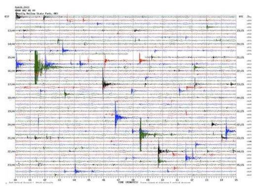
© Arkansas Geological SurveyIn this image provided by the Arkansas Geological Survey near Greenbrier, Ark., Thursday, Feb. 17, 2011, a seismic chart illustrating earthquake activity at Woolly Hollow State Park from noon to midnight on Feb. 16, is shown.
Greenbrier - Residents of the small north-central Arkansas town of Greenbrier said Monday they're unsettled by the fact that they never know if or when the next earthquake is going to strike, especially after being woken up by the largest quake to hit the state in decades.

The U.S. Geological Survey recorded the quake at 11 p.m. Sunday, centered beneath the ground about four miles northeast of Greenbrier. It was the largest of more than 800 quakes to strike the area since September in what is now being called the Guy-Greenbrier earthquake swarm.

"You don't know what to expect. It's unnerving," said Corinne Tarkington, an employee at a local flower and gift shop. "I woke up last night to the sound of my house shaking."

What woke Tarkington was a magnitude 4.7 earthquake - the largest to hit the state in 35 years. No injuries or major damage have been reported, but the escalation in the severity of quakes in and around the small north-central Arkansas town has many residents on edge. Some said they're seeing gradual damage to their homes, such as cracks in walls and driveways.

"We probably had 40 to 50 calls last night," Greenbrier police Sgt. Rick Woody said, noting that the tone of the calls had changed. After previous quakes, most callers simply wanted to find out if a loud noise they'd heard was an earthquake, he said.

Igloo

'Chandler's Wobble' May Usher in a New Ice Age

Last week in 'Gems,' we reported that NASA has discovered 'cracks' in the fluctuating earth's magnetic field.

This is worrisome, because this magnetic field affects the ionosphere, and particularly the winds in the lower troposphere. These 'cracks' in the magnetic field and the shifting of our planet's magnetic poles can lead to SUPER STORMS on virtually every continent like we've seen in recent months.

This month's mega-monster cyclone 'Yasi' left much of northeastern Australia in Queensland a "war zone," according to rescue workers. This incredible storm packed winds near 190 miles per hour. Although it was labeled as a Category '5' cyclone (hurricane/typhoon), theoretically it was an 'off the scale' Category '6'!

Tens of thousands of homes were severely damaged or destroyed. Hundreds of people died. Livestock herds were decimated. There were reports of "sharks swimming through the flooded houses."

As if these worsening superstorms aren't enough, we have 'Chandler's Wobble' to worry about.

It was first discovered by an American astronomer in 1891 by the name of Seth Carlo Chandler. Chandler said that the earth "wobbles like a top" whenever our planet slows down a bit in its rotation like it has in recent years.

According to NASA, "the track of this spin began to slow down very slightly about Jan. 18, 2006." Since then, we've had a series of EXTREMELY HARSH winter seasons in both hemispheres.

If this 'wobble' of the planet continues, it's entirely possible that we will eventually see at least a new 'Little Ice Age,' maybe even a new GREAT ICE AGE like the one approximately 11,500 years ago.