Earth ChangesS

Ice Cube

'Lowest temperaure in Bangladesh's history' brings at least 80 deaths

Image
A cold snap which saw temperatures drop to 40-year lows in Bangladesh has killed around 80 people, officials said.

According to AFP, Shah Alam, the deputy head of the weather office, said the lowest temperature was recorded at 3 degrees Celsius in the northern town of Syedpur.

He said the last time the temperature dropped below that level was in February 1968 when Bangladesh was still part of Pakistan.

"The temperature is the lowest in Bangladesh's history," he said.

The Red Crescent said hospitals were packed with patients suffering respiratory illness.

The society's general-secretary Abu Bakar said impoverished rural areas had been worst hit as many people could not afford warm clothing or heating.

Snowflake Cold

Unprecedented cold spell breaks 50-year records in Pakistan

Image
© thenewstribe.com
The winter, normally a season of feast and joy in the region, otherwise known for its enervating summers, has brought with it a strange phenomenon in recent weeks. Record chill has sent people scampering to keep themselves warm, and made commuting a dicey task, especially at night.

The strange thing about this phenomenon this season has been that it gripped the Pothohar region and the plains of Khyber Pakhtunkhwa as well, contrary to the trend of the past few decades when nearly blinding fog mostly affected the plain areas of the Punjab.

This time around, the 50-year cold records in the Punjab plains were broken, while also plunging the wide swathes of Pothohar and Khyber Pakhtunkhwa in an unprecedented cold spell, which spread over a fortnight or even three weeks, with weather pundits saying that maximum temperatures fell by as much as 10 degree Celsius.

After shivering even in the daytime during the two days in the 'aftermath' of fog-induced cold, Tuesday night brought with it some cheers for the winter-weary people, as a cloudy sky prevented fog to accumulate, also bringing visibility level back to normal for the traffic and keeping the temperatures from dipping to sub-zero level, as was seen in the previous two weeks.

Sun

Hundreds of U.S. counties labeled disaster areas due to drought

Image
© CNNThe drought has had a negative impact on corn in Le Roy, Illinois. The hottest year on record is expected to drive up food prices by 2013 due to lower crop harvests.
The U.S. Agriculture Department cited drought and heat on Wednesday in designating 597 counties in 14 states as primary natural disaster areas.

"As drought persists, USDA will continue to partner with producers to see them through longer-term recovery, while taking the swift actions needed to help farmers and ranchers prepare their land and operations for the upcoming planting season," Agriculture Secretary Tom Vilsack said in a statement.

The designations make qualified farmers in the areas eligible for low-interest loans, the agency said.

Affected counties have suffered severe drought for eight consecutive weeks, which qualified them for the automatic designation.

Richard Oswald, a 62-year-old farmer in Missouri's Atchison County, said he has been hit hard by the drought but was not sure whether he would take advantage of the drought designation for his county by getting a low-interest loan.

Snowflake Cold

Heavy snow, torrential rain, gale-force winds batter Greece

Image
© ekathimerini
Bad weather conditions of heavy snowfall, strong torrential rains, sub-zero temperatures and gale-force winds continued to batter parts of the mainland and the Aegean Sea islands in Greece on Wednesday for a third day this week, disrupting land and sea transport.

Several mountainous areas in particular in northern and central provinces, some suburbs of the Greek capital, as well as the southern island of Crete, have been most affected with blocked motorways even for vehicles with snow chains and closure of schools.

As winds of up to 8 on the Beaufort scale sweep the Aegean Sea, a ferry boat crashed into the dock of a port at the eastern island of Lesvos with no injuries or major damage caused, local authorities said.

The Greek National Meteorological Service (EMY) reported the lowest temperature over the past few days, as the thermometer plunged to -11 Celsius in the northern city of Nevrokopi. Experts at EMY forecast that the cold snap will subside on Thursday.

Cloud Grey

Red dust sunset in Australia - Freakish dust storm settles over Western Australia

Mother Nature put on a spectacular display off the coast of Onslow yesterday, where a menacing-looking storm was captured on camera by a tug boat worker. Jurien Bay man Brett Martin and his colleagues were working west of False Island when the thunderstorm, which had gathered dust and sand as it developed, passed over Onslow and out to the Indian Ocean. Mr Martin said the storm built up in a matter of minutes.
Image
© Brett Martin/perthweatherlive.com
"We were steaming along in the boat just before sunset and the storm was casually building in the distance, then it got faster and faster and it went from glass to about 40 knots in two minutes," he said. "It was like a big dust storm under a thunderhead, there was a lot of lightning but not a lot of rain." Bureau of Meteorology duty forecaster Austen Watkins said the stunning view was created as wind and rain caused the storm to dump the sand and dust it had ingested while passing Onslow.

Additional images

Ice Cube

Phoenix, Arizona to break 25-year record low - 15 degrees below normal

Crank up the heat: It's going to be plenty cold in the Valley this weekend. Weather analysts are forecasting four days of freezing temperatures, starting Saturday night, running through Tuesday. The last time the Valley had four straight sub-freezing mornings was 25 years ago. Rain also is expected to arrive between 9 p.m. and midnight Thursday.

Chris Kuhlman with the National Weather Service said it will be a struggle to reach 50 degrees Friday.

"It will be very cold. Some areas will see the mid-20s for lows," Kuhlman said. "Other areas will be right at the freezing mark and below. This is a very large system coming off the north Pacific and very cold.

"Right now it's going across California and then we have a reinforcing shot of cold air coming down from western Canada on Sunday and that will keep our area temperatures about 15 degrees below normal."

Phoenix

Australian heatwave nears 50C inland as severe fire threat declared

Image
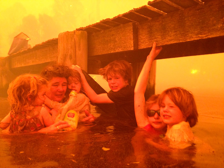
© Tim Holmes/AP Five young children and their grandmother huddled together under a jetty in the Tasmanian town of Dunalley were photographed by their grandfather Tim Holmes. The family was forced to stay in the water for several hours as homes around them were razed to the ground. Tammy Holmes, second from left, and her grandchildren, two-year-old Charlotte Walker, left, four-year-old Esther Walker, third from left, nine-year-old Liam Walker, eleven-year-old Matilda, second from right, and six-year-old Caleb Walker, right, take refuge under a jetty as a wildfire rages near-by.
Danger rating is two levels down from 'catastrophic' warning after two days of relative cool, but temperatures rising again

Australia is bracing for more potentially dangerous fires, with temperatures on Friday predicted to soar close to 50C in the centre of the continent and up to 46C in parts of New South Wales.

The return of the scorching heat follows two days of relative cool, during which fire crews tackled more than 100 blazes still burning in New South Wales and Victoria, and built containment lines for more outbreaks.

"We are entering a very challenging fire weather period over the next three days," said Brydie O'Connor, of the New South Wales rural fire service. "We'll have 40 degree-plus days in many parts, with a number of fires from Tuesday still burning. Add that to some very strong north-westerly winds and we've got a very bad situation."

Comment: If the suggestion here is that Britain's lower so-called 'carbon footprint' than Australia's in some way implies that Britain is doing its part to save the planet, then, like everyone else taken in by the green movement, the author is completely deluded as to what is really behind 'climate change'.

Getting back to the real issue at hand, we wonder if fireballs reaching the lower atmosphere were at least partly responsible for sparking these wildfires?

Reign of Fire: Meteorites, Wildfires, Planetary Chaos and the Sixth Extinction


Sun

Extreme heat decimates Australian bat colony

flying fox
© UnknownWildlife Rescue South Coast Incโ€™s Gerardine Hawkins with one of the rescued grey-headed flying foxes from the local colony that was decimated in Tuesdayโ€™s extreme heat.
Tuesday's heat episode has decimated one of the Shoalhaven's flying fox colonies.

As temperatures soared above 40 degrees the grey-headed flying fox, which is listed as vulnerable, fell victim to the heat with at least 1000 members of the 11,500 strong colony being found dead.

Volunteers from Wildlife Rescue South Coast along with National Parks staff spent numerous hours in the colony on Tuesday trying to save the dying animals.

Windsock

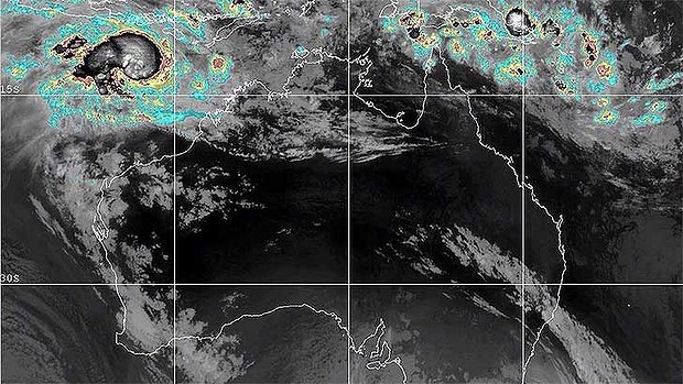
Cyclone Narelle set to bring dangerous conditions to Western Australia

Cyclone Narelle
© Higgins Storm ChasingThis satellite image shows Cyclone Narelle forming off the north-west coast of WA.
People in the Pilbara are preparing for dangerous weather conditions, as Cyclone Narelle bears down ominously on WA's north-west coast

The eye-catching photographs accompanying this story were captured by Brett Martin just before sunset on Wednesday afternoon, 25 nautical miles north-west of Onslow.

They depict a "tropical squall line" and a "gust front ahead of a storm line", with the red tinge resulting from dust picked up in the Pilbara on the way out to sea.

Boat

Boat caught in middle of dolphin stampede off Dana Point, California


It was a rare, breathtaking sight: In a flash, a pod of about 1,000 common dolphins began a stampede, churning across the blue-gray waters off Dana Point at a rapid pace.

Dave Anderson, the captain of Capt. Dave's Dolphin and Whale Safari, said that in the decades he's spent on the water and out among Southern California's dense dolphin population, it's a phenomenon he's encountered only rarely.

Yet last weekend, it happened again ... and it happened twice: once on Saturday afternoon and again on Sunday morning. Boat hands captured Sunday's stampede on video.

"It's one of those things you can hope for it, but you can't plan for it," he said.

"It's one of the most amazing things I've ever seen, and I've seen a lot of beautiful and interesting things" on the water.