Earth ChangesS


Radar

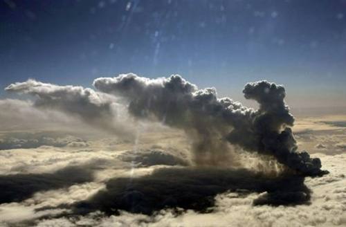
Volcano's ash cloud causes flight chaos across Europe

Tens of thousands of people across northern Europe have faced flight disruptions after a dangerous ash cloud from a volcano eruption in Iceland billowed throughout the region's skies.

Airports across UK, Ireland, Norway, Holland and Finland have closed down their airspaces, cancelling all flights.


Stop

Iceland Volcano Ash Disrupts European Flights

Manchester Airport
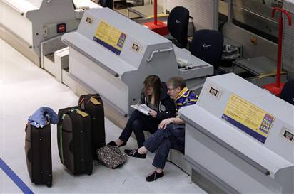
© Phil Noble / Reuters Passengers wait, after flights were disrupted, in a terminal in Manchester Airport, Manchester, northern England April 15, 2010.
London - Ash clouds drifting from Iceland's erupting volcano disrupted air traffic across Northern Europe Thursday, forcing airports to close and the cancellation of hundreds of flights in Britain, Ireland and the Nordic countries.

In Iceland, hundreds have fled from floodwaters rising since the volcano under the Eyjafjallajokull glacier erupted Wednesday for the second time in less than a month. As water gushed down the mountainside, rivers had risen by up to 10 feet by Wednesday night.

The volcano was sending up smoke and ash that posed "a significant safety threat to aircraft," Britain's National Air Traffic Service said, as visibility is compromised and debris can get sucked into airplane engines.

Fish

Ocean salinities show planet's water cycle has intensified

Image
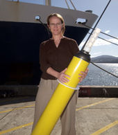
© CSIROCSIRO Wealth from Oceans scientist, Dr Susan Wijffels, who shares the helm of the world’s largest ocean monitoring program aimed at reducing uncertainties about climate change.
Evidence that the world's water cycle has already intensified is contained in new research to be published in the American Journal of Climate.

The stronger water cycle means arid regions have become drier and high rainfall regions wetter as atmospheric temperature increases.

The study, co-authored by CSIRO scientists Paul Durack and Dr Susan Wijffels, shows the surface ocean beneath rainfall-dominated regions has freshened, whereas ocean regions dominated by evaporation are saltier. The paper also confirms that surface warming of the world's oceans over the past 50 years has penetrated into the oceans' interior changing deep-ocean salinity patterns.

"This is further confirmation from the global ocean that the Earth's water cycle has accelerated," says Mr Durack - a PhD student at the joint CSIRO/University of Tasmania, Quantitative Marine Science program.

"These broad-scale patterns of change are qualitatively consistent with simulations reported by the Intergovernmental Panel on Climate Change (IPCC).

Comment: Good disinfo comes with a kernel of truth. It's impossible to get any climate related study published today without couching it in terms of "man made global warming caused by increased CO2 emissions."

Climategate: One Must Ignore 200 Years of Observations to Believe in AGW

Yes, the oceans are doing as described above, but not because of "global warming" as explicated by the IPCC. The oceans are heating due to undersea volcanic activity. At the same time, the upper atmosphere is cooling due to increased cosmic dust. As noted above, this has produced increased evaporation which leads to increased precipitation in the form of rain and snow.


Bizarro Earth

Supervolcano: How humanity survived its darkest hour

Image
© Sipa Press/Rex FeaturesThe landscape after Pinatubo's eruption may give a glimpse of what early humans experienced
The first sign that something had gone terribly wrong was a deep rumbling roar. Hours later the choking ash arrived, falling like snow in a relentless storm that raged for over two weeks. Despite being more than 2000 kilometres from the eruption, hominins living as far away as eastern India would have felt Toba's fury.

Toba is a supervolcano on the Indonesian island of Sumatra. It has blown its top many times but this eruption, 74,000 years ago, was exceptional. Releasing 2500 cubic kilometres of magma - nearly twice the volume of mount Everest - the eruption was more than 5000 times as large as the 1980 eruption of mount St Helens in the US, making it the largest eruption on Earth in the last 2 million years.

The disaster is particularly significant since it occurred at a crucial period in human prehistory - when Neanderthals and other hominins roamed much of Asia and Europe, and around the time our direct ancestors, Homo sapiens, were first leaving Africa to ultimately conquer the world. Yet with no recent eruptions for easy comparison, the full extent of its fallout and impact on early humans has been shrouded in mystery.

Now dramatic finds from archaeological digs in India, presented in February at a conference at the University of Oxford, are finally clarifying the picture of the eruption and its effects, and how it shaped human evolution and migration. Further results from the digs may even rewrite the timing and route that modern humans took out of Africa.

Bizarro Earth

Cyclone Kills 89 People in Eastern India

A cyclone packing winds of more than 100 mph (160 kph) demolished ten of thousands of mud huts in northeastern India, killing at least 89 villagers, officials said Wednesday.

The cyclone struck close to midnight on Tuesday in northeastern parts of West Bengal and Bihar states, uprooting trees and snapping telephone and electricity lines, West Bengal Civil Defense Minister Srikumar Mukherjee said. Hundreds of people were injured and many thousands left homeless.

Devesh Chandra Thakur, Bihar state's Minister for Disaster Management, said there was no cyclone warning from the weather department, so villagers were unprepared.

Television footage showed uprooted trees lying across shanties and sheets of corrugated metal ripped from the roofs of homes. Small children sat outside their damaged huts as parents tried to salvage their belongings from inside.

Bizarro Earth

Glacier breaks in Peru, causing tsunami in Andes

Image
© Municipality of CarhuazHuancan peak seeing from a hill close to Carhuaz.
A huge glacier broke off and plunged into a lake in Peru, causing a 75-foot (23-metre) tsunami wave that swept away at least three people and destroyed a water processing plant serving 60,000 local residents, government officials said on Monday.

The ice block tumbled into a lake in the Andes on Sunday near the town of Carhuaz, some 200 miles (320 km) north of the capital, Lima. Three people were feared buried in debris.

Investigators said the chunk of ice from the Hualcan glacier measured 1,640 feet (500 metres) by 656 feet (200 metres).

"This slide into the lake generated a tsunami wave, which breached the lake's levees, which are 23 metres high -- meaning the wave was 23 metres high," said Patricio Vaderrama, an expert on glaciers at Peru's Institute of Mine Engineers.

Bizarro Earth

Taiwan: Mud volcano eruption intrigues locals

The mud volcano in Yushan Village of Nanhua Township erupted again on April 12, creating a boiling pot of soup-like mud. Retired teacher Lai Ming-chang says that the mountain erupts once every three or four months, and that this is a normal release of energy rather than a sign of an impending major earthquake.

At about 7 a.m., Lai was told by a landowner that another eruption was underway. As soon as it started, the surface of the water began bubbling, and the smell of gases released from the water got stronger and stronger. Around noon, the force of the eruption started mounting gradually, and it had reached its peak by 3 p.m. Mud was pouring outward from the middle, getting higher and higher. "It looked as though there was a pot of boiling soup on a burner," bystanders said.

Being a long-time observer of these eruptions, Lai says that the last eruption occurred on January 9, and they generally last between 24 and 26 hours. The water inside the volcano will dry up again in three days, but when they seep out to form an underground lake, the volcano will erupt again.

Igloo

Iceland evacuates hundreds as volcano erupts again

Image
© Icelandic Coast GuardThis second eruption in as many months was between ten and twenty times more powerful than the first
Reykjavik - A volcano under a glacier in Iceland rumbled back to life Wednesday, melting ice, shooting smoke and steam into the air and forcing hundreds of people to leave their homes as floodwaters rose.

Emergency officials evacuated 800 residents from around the Eyjafjallajokull glacier as rivers rose by up to 10 feet (3 meters) and flooded a sparsely populated area, said Rognvaldur Olafsson, a chief inspector for the Icelandic Civil Protection Agency.

He said no lives or properties were in immediate danger. Scientists said there was no sign of increased activity at the much larger Katla volcano nearby.

Pall Einarsson, a geophysicist at the University of Iceland, said magma was melting a hole in the 650-foot (200 meter) thick ice covering the volcano's crater, sending floodwater coursing down the glacier into lowland areas.

Bizarro Earth

Update: Strong quake in western China's Qinghai kills 300

Earthquake Qinghai
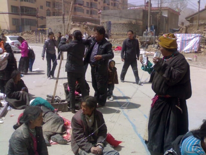
© Associated Press In this photo taken by a mobile phone, local people gather outside after being evacuated from buildings following an earthquake that hit the Tibetan area in Qinghai's south.
Beijing - A series of strong earthquakes struck China's western Qinghai province Wednesday, killing at least 300 people, injuring thousands and burying many others under toppled houses in a mountainous rural area, officials and state media said.

The U.S. Geological Survey said a magnitude 6.9 temblor struck an area in southern Qinghai, near Tibet, on Wednesday morning and was followed by several aftershocks.

The main quake sent residents fleeing as it toppled houses made of mud and wood, said Karsum Nyima, the Yushu county television station's deputy head of news, speaking by phone with broadcaster CCTV.

"In a flash, the houses went down. It was a terrible earthquake," he said. "In a small park, there is a Buddhist tower and the top of the tower fell off. ... Everybody is out on the streets, standing in front of their houses, trying to find their family members."

The quake hit the county of Yushu, a Tibetan area in Qinghai's south, said the China Earthquake Networks Center, which measured the quake's magnitude at 7.1. A local government Web site put the county's population in 2005 at 89,300, a community of mostly herders and farmers.
Bizarro Earth

Oil from Barrier Reef crash washes up on sanctuary

Image
© AFP/GraphicA map of Australia's Great Barrier Reef, locating the area where a Chinese-registered carrier ran aground and caused a three-kilometre slick. Australian officials raced against the clock to refloat a massive Chinese ship which grounded and leaked oil at the Great Barrier Reef before high winds and heavy seas rock the region.
Sydney - Globules of oil believed to be from a Chinese ship that slammed into Australia's Great Barrier Reef are washing up on a nearby wildlife sanctuary, officials said Wednesday in the latest environmental fallout from the crash.

The Shen Neng 1 coal carrier veered into protected waters and ran aground on Douglas Shoal on April 3, immediately leaking 2-3 tons of fuel when coral shredded its hull. The vessel tore a 2-mile- (3-kilometer-) long gash into the shoal, causing damage that one leading marine scientist said could take up to 20 years to heal.

On Wednesday, a team of about 25 people was working to clean up bits of oil that had begun washing ashore on North West Island, a turtle hatchery and bird sanctuary about 12 miles (18 kilometers) from where the ship crashed into the reef, said Adam Nicholson, a maritime safety spokesman for the northeastern state of Queensland.

The globules were about an inch (3 centimeters) wide, and were scattered across about a half-mile (1 kilometer) of beach on the island, the second largest coral key on the reef.