
Earth ChangesS


Evil Rays

Temblor Tilts Earth by Inches

Image
© Martin Bernetti/AFP/Getty ImagesFirefighters searched for victims in the debris of a house in Curanipe.
The earthquake that struck Chile was so powerful it shifted the planet's axis enough to make it spin slightly faster, meaning our days will be shorter by 1.26 millionths of a second, according to preliminary calculations by scientists at the National Aeronautics and Space Administration.

"This is an esoteric effect that physics says has to happen," notes David Kerridge, the British Geological Survey's head of natural hazards, who studies earthquakes. "It's interesting, but it has no particular consequence on anything."


Comment: NASA scientists claimed the Chilean earthquake shifted the Earth's axis by "2.7 milliarcseconds (about 8 centimeters or 3 inches)" and shortened the day by "1.26 microseconds (millionths of a second)". Just one strong quake, imagine! But the claim was countered as unverifiable and ludicrous by German scientists:
Professor Rainer Kind from the German Research Centre for Geosciences (GFZ) in Potsdam said: "It is highly doubtful that these calculations are correct. The changes to the Earth's axis caused by an earthquake would be so tiny that it isn't measurable and therefore impossible to reliably detect."

Existing calculations of the movement of the Earth's axis by past earthquakes are still being debated, the expert added.

Professor Karl-Heinz Glassmeier from the Deutschen Geophysikalischen Gesellschaft (German Geophysical Association) also criticised the alleged discovery: "I hit my hand on my head as I read that yesterday.

"NASA can only make the headlines with it. A figure of eight centimetres is absolutely unverifiable."

The influence of an earthquake on the Earth's tilt would in any case be extremely low, explained Dr. Mojib Latif from The Leibniz Institute of Marine Sciences in Kiel.

He said: "The heavenly bodies around us are mainly responsible for the Earth's tilt. The gravity of the heavy and big planets in particular determines the gradient of the Earth's axis.

"That can not be changed by an earthquake, even one as powerful as that in Chile."

Professor Kind added: "It is impossible that there could ever be such a severe earthquake which would observably move the Earth's axis. That would only be possible through outside influences, for example a meteorite.

"The destruction however would be so great, that the movement of the Earth's axis would be comparatively insignificant."
So while a strong earthquake may not be sufficient to shift the planet's axis and thus alter the length of days, it's conceivable that a change in the arrangement of "the heavenly bodies" might well do so. The good professor probably didn't have this in mind when he used that term, but if we consider that comets and their debris trails are also "heavenly bodies", then we can see that earthquakes may be a symptom of an external cosmic force affecting Earth's rotation. Any slowing down of rotation, however imperceptible, would be sufficient to affect the magnetic field and produce incredible pressures within the planet that then shift tectonic plates, resulting in more earthquakes and volcanic eruptions as that pressure is released.


Evil Rays

Chile Quake Tilts Earth's Axis

Image
© Martin Bernetti/AFP/Getty ImagesA boat grounded by the tsunami March 2, 2010 in the fishing village of Constitucion, central Chile.
While scientists and geophysicists around the world are researching ways to identify when an earthquake may occur, it is still not possible to predict the exact time and magnitude of an earthquake. However, what is known is that certain places on the planet are always at risk from big tremors. Chile is one of those places.

One of the most seismically active areas on the planet, Chile has experienced 13 events of magnitude 7.0 or greater since the 1970s.

In 1960, it also experienced the world's strongest quake, magnitude 9.5, which, in combination with tsunami waves and earthquake devastation, left 1,655 dead and 2 million homeless.

Chile lies on a zone of quake and volcanic instability that encircles the Pacific Ocean known as the "Ring of Fire."

Comment: NASA scientists claimed the Chilean earthquake shifted the Earth's axis by "2.7 milliarcseconds (about 8 centimeters or 3 inches)" and shortened the day by "1.26 microseconds (millionths of a second)". Just one strong quake, imagine! But the claim was countered as unverifiable and ludicrous by German scientists:
Professor Rainer Kind from the German Research Centre for Geosciences (GFZ) in Potsdam said: "It is highly doubtful that these calculations are correct. The changes to the Earth's axis caused by an earthquake would be so tiny that it isn't measurable and therefore impossible to reliably detect."

Existing calculations of the movement of the Earth's axis by past earthquakes are still being debated, the expert added.

Professor Karl-Heinz Glassmeier from the Deutschen Geophysikalischen Gesellschaft (German Geophysical Association) also criticised the alleged discovery: "I hit my hand on my head as I read that yesterday.

"NASA can only make the headlines with it. A figure of eight centimetres is absolutely unverifiable."

The influence of an earthquake on the Earth's tilt would in any case be extremely low, explained Dr. Mojib Latif from The Leibniz Institute of Marine Sciences in Kiel.

He said: "The heavenly bodies around us are mainly responsible for the Earth's tilt. The gravity of the heavy and big planets in particular determines the gradient of the Earth's axis.

"That can not be changed by an earthquake, even one as powerful as that in Chile."

Professor Kind added: "It is impossible that there could ever be such a severe earthquake which would observably move the Earth's axis. That would only be possible through outside influences, for example a meteorite.

"The destruction however would be so great, that the movement of the Earth's axis would be comparatively insignificant."
So while a strong earthquake may not be sufficient to shift the planet's axis and thus alter the length of days, it's conceivable that a change in the arrangement of "the heavenly bodies" might well do so. The good professor probably didn't have this in mind when he used that term, but if we consider that comets and their debris trails are also "heavenly bodies", then we can see that earthquakes may be a symptom of an external cosmic force affecting Earth's rotation. Any slowing down of rotation, however imperceptible, would be sufficient to affect the magnetic field and produce incredible pressures within the planet that then shift tectonic plates, resulting in more earthquakes and volcanic eruptions as that pressure is released.


Bulb

Ridiculous! Lights out for Earth Hour

Hey Toronto, flick off!

People around the globe will turn off the lights Saturday for Earth Hour, time zone by time zone, as clocks strike 8:30 p.m.

What started in 2007 with 2.2 million homes and businesses turning off their lights for one hour in Sydney, Australia, grew last year to hundreds of millions of people in more than 4,000 cities in 88 countries standing, sitting and dancing their way through 60 minutes of darkness.

Though a serious cause - the World Wildlife Fund organizes Earth Hour as a stand against climate change - it has turned into a festive event.

The City of Toronto will mark the evening with performances by Chantal Kreviazuk, Jarvis Church and Justin Nozuka at Yonge-Dundas Square.

Stop

EPA might halt West Virginia mountaintop coal mine

The U.S. Environmental Protection Agency yesterday took a rare step against a proposed "mountaintop" coal mine in West Virginia, proposing to block the mine even though it has a federal permit.

The move is one of the most aggressive to come out of the Obama administration's re-examination of mountaintop mining, in which peaks are scraped and blasted away to reach coal seams inside. The EPA has reviewed dozens of permits and approved one large mine in January after environmental improvements were promised.

But, in this case, the agency is threatening to stop the Spruce No. 1 mine in Logan County entirely, or at least stop it from depositing excess rock and rubble in nearby streams.

Smiley

Bengal Island succumbs to global warming nonsense - Associated Press gets nutty over the loss of a sandbar

This article provides a sound debunking of biased and somewhat hysterical reporting about the supposed disappearance of a rocky island in Bengal. The island actually turns out to be an estuary island, otherwise known as a sandbank.
New Moore Island in the Sunderbans has been completely submerged.

New Moore Island in the Sunderbans has been completely submerged. Photo - Das/AP
From the New York Daily News via Associated Press reports :
Global warming resolves 30-year land dispute between India, Bangladesh: Coveted island sinks

By NIRMALA GEORGE, Associated Press Writer Nirmala George, Associated Press Writer - Wed Mar 24, 9:29 am ET

NEW DELHI - For nearly 30 years, India and Bangladesh have argued over control of a tiny rock island in the Bay of Bengal. Now rising sea levels have resolved the dispute for them: the island's gone.

New Moore Island in the Sunderbans has been completely submerged, said oceanographer Sugata Hazra, a professor at Jadavpur University in Calcutta. Its disappearance has been confirmed by satellite imagery and sea patrols, he said. "What these two countries could not achieve from years of talking, has been resolved by global warming," said Hazra.
Note in the map below that the island was a river estuary, meaning it wasn't made out of rock as claimed. It was made out of mud and sand. From Wikipedia:
The island was situated only two kilometers from the mouth of the Hariabhanga River. The emergence of the island was first discovered by an American satellite in 1974 that showed the island to have an area of 2,500 sq meters (27,000 sq ft). Later, various remote sensing surveys showed that the island had expanded gradually to an area of about 10,000 sq meters (110,000 sq ft) at low tide, including a number of ordinarily submerged shoals. The highest elevation of the island had never exceeded two meters above sea level. [1]

...

The island was claimed by both Bangladesh and India, although neither country established any permanent settlement there because of the island's geographical instability. India had reportedly hoisted the Indian flag on South Talpatti in 1981 and established a temporary base of Border Security Forces (BSF) on the island, regularly visiting with naval gunships. [3][4]
Bizarro Earth

Brazilian Senate debates dire situation of Guarani Indians

Guarani
© João RipperGuarani children
Five days after the publication of Survival International's report on the Guarani to the UN which highlighted the denial of their land rights by the Brazilian government, the Brazilian Senate's Human Rights Commission this Tuesday met to discuss the serious problems of discrimination and violence which the Guarani face.

Present at the meeting were various senators, indigenous representatives, the federal prosecutor working on Guarani land cases, and anthropologists.

Senator Marina Silva, who called the debate, stated that the increase in the cultivation of soya and sugar cane and the growth of the beef industry are provoking violence against the Guarani and forcing them to leave their ancestral lands.

She added that this upheaval is putting the lives of the Guarani at risk, and that the rates of alcoholism, malnutrition and suicide have increased amongst the Guarani population.

Bizarro Earth

Magnitude 6.2 - Atacama, Chile

Chile Earthquake
© USGSEarthquake Location
Date-Time:
Friday, March 26, 2010 at 14:52:06 UTC

Friday, March 26, 2010 at 10:52:06 AM at epicenter

Location:
27.985°S, 70.709°W

Depth:
35 km (21.7 miles)

Distances:
65 km (40 miles) N of Vallenar, Chile

80 km (50 miles) SSW of Copiapo, Chile

225 km (140 miles) NNE of Coquimbo, Chile

605 km (375 miles) N of SANTIAGO, Chile

Igloo

Harshest Winter in 31 Years for Europe

Image
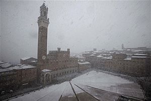
© AP Photo/Paolo LazzeroniSnow covers Siena's historical Piazza Del Campo, Italy, Tuesday, March 9, 2010.
The winter of 2009-10 in Europe will make its way into the history books as being the harshest winter Britain and Western Europe has seen in the last 31 years.

The wettest summer on record in Britain was followed by a harsh winter that took lives and caused millions of dollars worth of damage, both structural and economic.

January was the eighth coldest on record and the U.K.'s worst since 1987.

Precise snowfall records are notoriously hard to find for Europe; however, record snowfall affected London and parts of Scotland this winter. In one 16-hour storm Perth, Scotland, received 13 inches of snow.

Snowman

Updated Snowfall Record Information For Wichita Falls and Oklahoma City

Having experienced several significant storms this winter, parts of western and central Oklahoma and western North Texas have seen their seasonal snowfall totals for 2009-2010 grow to considerable levels. When we talk about seasonal snowfall totals we mean the amount of snow that falls over the course of the winter, rather than in a calendar year. Here at the NWS Norman forecast office, we have two sites with a reliable snowfall record that dates back many decades - Oklahoma City (OKC) and Wichita Falls (SPS). Below, you will see some of the statistics for this winter's snowfall at both of those sites. These figures will be updated over the next several months.

Visit event writeups for some of the significant winter storms we've had this year: the Christmas Eve blizzard and the January 28-29, 2010 winter storm.

Oklahoma City (Records back to 1892-1893 winter)
  • 5th Highest Total Seasonal Snowfall - 23.2"
  • The seasonal snowfall so far is the most since the 1987-1988 winter (22 years).
  • Snowiest December on Record - 14.0", breaking the previous record of 9.0" in 1914-1915
  • Record storm total snowfall - 13.5" on December 24, 2009
In order to break the seasonal snowfall record, Oklahoma City would need to measure an additional 2.1 inches of snow. Oklahoma City averages 8.6 inches of snow every winter, with 0.7 inches in March. Averages are computed using the 1971-2000 period of record. The latest measurable snowfall that occurred in a winter season was on April 14, 1953, when 0.8 inches of snow was observed.

Cloud Lightning

Spring snowstorm blasts Colorado

Image
© David Zalubowski, APPedestrians struggle to hold on to their umbrellas as they navigate through a snowstorm in downtown Denver on Tuesday, March 23. Almost 2 feet of snow was recorded west of Denver as of Wednesday morning.
Denver - A spring snowstorm that whipped though Colorado left the state a slushy mess Wednesday, with thousands stuck at Denver's airport or left without power or schools.

The heavy snowmaker dumped more snow than even some spring break ski vacationers bargained for.

"We were supposed to leave yesterday," said Jenny Gossow of St. Louis, who missed a flight out of Denver after a family spring break ski trip to Telluride, Colo. Gossow, along with her husband and three children, spent Tuesday evening snoozing on blue mats Denver International Airport provided for an estimated 5,000 stranded travelers.