Earth ChangesS


Bizarro Earth

US: Washing Away the Fields of Iowa

Image
© Environmental Working GroupSoil Erosion rates by county in 2007
To an untrained eye, the fields of Iowa have a reassuring solidity. You cannot tell that the state has lost half its topsoil in the past century. According to a new report from the Environmental Working Group, Iowa's soil is washing away at rates far higher than anyone realized.

For Iowa - and other Corn Belt states facing similar problems - this means an increasing loss of fertility that has to be replaced chemically. It marks a failure of stewardship, since these soils will have to feed future generations. And every particle that washes away causes problems downstream, including sedimentation - which can increase the risk of flooding - and the alarming dead zone in the Gulf of Mexico, the result of runoff of the chemical fertilizers farmers apply to make up for lost fertility.

The Agriculture Department says that a "sustainable" rate of topsoil loss for most of Iowa is 5 tons per acre per year, and the actual average soil erosion is 5.2 tons. But using Iowa State University statistics and an aerial survey, the Environmental Working Group concluded that average annual soil loss in much of Iowa is double the federal government's estimates. This pace of erosion is caused partly by an increasing number of intense storms. As the report says, it has been exacerbated by a fundamental bias in federal farm policy and supports. In the dozen years before 2009, Iowa received nearly $17 billion in subsidies that fostered high-intensity farming and less than $3 billion to support conservation. In the recent budget battles, conservation programs were the hardest-hit farm programs.

Info

UK: Mysterious hole sparks fears in Harlesden

Image
© UnknowwnRay Szynowski says the hole myseriously appeared without any sign of what caused it
Residents were shocked to find this gaping hole as they arrived back from work late one afternoon.

The crevice, which is some 3ft deep and 2ft wide, appeared in Leopold Road, Harlesden without any sign of what caused it.

Concerned residents spotted the hole shortly before 5pm last Wednesday, and rushed out to put up makeshift barriers and scrawled a 'danger' sign warning motorists and pedestrians of the hazard.

Family

Earthquake hits southern Spain, ten dead

Image
© Unknown
Damaged cars in Lorca after the earthquake
At least ten people were reported dead and dozens injured after an earthquake shook southeastern Spain on Wednesday, toppling historic buildings in the medieval town of Lorca.

A 5.1 magnitude earthquake has hit the town of Lorca in southern Spain, leaving seven people dead and several medieval buildings collapsed.

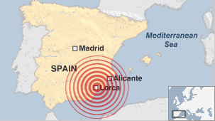
The 5.2 magnitude earthquake was felt across the Murcia region, where hundreds of British expatriate live, from Alicante to Malaga and as far away as Madrid.

A 5.1 magnitude earthquake has hit the town of Lorca in southern Spain, leaving a seven people dead and several medieval buildings collapsed.

Bizarro Earth

Magnitude 5.3 earthquake kills at least 4 in Spain

5.3 earthquake spain
© Unknown
A magnitude 5.3 earthquake has toppled several buildings in southern Spain, near the town of Lorca, killing at least four people, officials say.

The quake struck at a depth of just 1km (0.6 miles), some 120km south-west of Alicante, at 1850 (1650 GMT), the US Geological Survey reported.

TV shots showed rescue workers rushing through debris-littered streets.

Lorca Mayor Francisco Jodar told local radio the four deaths were caused by falling debris and cave-ins.

Old buildings, including a clocktower, were badly damaged by the quake, which followed a smaller 4.4-magnitude quake about two hours earlier.

Spain's Prime Minister Jose Luis Rodriguez Zapatero has deployed emergency military units to the scene, the Spanish EFE news agency reported.

Earthquakes are common in southern Spain, but they rarely result in casualties.

A number of aftershocks have been felt in the Murcia region, where authorities fear the death toll could rise.

The area worst hit by Tuesday's quake suffered previous tremors in 2005 and 1999.

Control Panel

Best of the Web: Volcano heats high-mountain lake to 108 degrees - Now imagine what a few thousand underwater volcanoes could do

Image
© Unknown
Last month, the Philippine Institute of Volcanology and Seismology (Phivolcs) announced that the water temperature in the main crater of Taal volcano in the Philippines had risen from 86.9 degrees Fahrenheit to 88.7 degrees Fahrenheit (30.5C to 31.5C), a sign that the volcano might soon erupt.

This provides an example of how much heat a volcano can generate.

And this is not the only lake that's running hot.

On March 1st of this year, the water temperature in New Zealand's Mt Ruapehu crater lake reached an astounding 105.8 degrees Fahrenheit (41C).

This was just short of the highest temperature ever reached since the lake was re-established in 2002, say volcanologists from New Zealand's Institute of Geological and Nuclear Sciences (GNS).

"The highest recorded temperature was 42.5degC (108.5F) in May 2003," says GeoNet duty volcanologist Agnes Mazot.

"The temperature of Crater Lake is a measure of amount of volcanic heat coming from Ruapehu," Mazot added.

Bizarro Earth

US: Wild April 2011 Weather: Historic Month by the Numbers

Wild Weather
© NOAA

April 2011 sure was a wild weather month. A record-breaking tornado outbreak capped a month of extremes, and many natural disasters, including historic flooding and devastating wildfires, continue into May.

Here are the numbers, according to the National Climatic Data Center in Asheville, N.C.

Temperature

Average U.S. temperature in April: 52.9 degrees Fahrenheit (11.6 degrees Celsius).

Degrees above the 1901-2000 average: 0.9 degrees F (0.5 degrees C).

State that had its warmest April on record: Delaware. April 2011 was the fourth warmest April for Virginia and the fifth warmest for Texas. Florida and Louisiana had their seventh warmest, New Mexico and West Virginia their eighth, New Jersey its ninth and Maryland its 10th.

Washington State came in at its second coolest April, 5 degrees F (2.8 degrees C) below their long-term average. Oregon (with its fifth coolest April) and Idaho (10th coolest) were also much cooler than normal.

Heart - Black

Dozens of dolphins found dead in Ukraine

Image
© Unknown

Thirty one dolphins were found dead in the Crimean Peninsula in Southern Ukraine, the press office of the Emergencies Ministry in Crimea reported Tuesday.

According to officials, the dead dolphins were scattered in an area of 2 km along the coastal zone.

Experts said the probable cause of the mammalian deaths is getting into the fishing nets. The majority of the dolphins have visible wounds on their body, some of them have damaged or missing fins.

Nuke

When We Tested Nuclear Bombs

Since the time of Trinity -- the first nuclear explosion in 1945 -- nearly 2,000 nuclear tests have been performed, with the majority taking place during the 1960s and 1970s. When the technology was new, tests were frequent and often spectacular, and led to the development of newer, more deadly weapons. But starting in the 1990s, there have been efforts to limit the future testing of nuclear weapons, including a U.S. moratorium and a U.N. comprehensive test ban treaty. As a result, testing has slowed -- though not halted -- and there are questions about the future. Who will take over for those experienced engineers who are now near retirement, and should we act as stewards with our enormous stockpiles of nuclear weapons? Gathered here are images from the first 30 years of nuclear testing. See also "Can We Unlearn the Bomb?" and "Atomic Weapons on Film."

Image
© US DODA fireball begins to rise, and the world's first atomic mushroom cloud begins to form, nine seconds after Trinity detonated on July 16, 1945.

Comment: Still think smoking is to blame for lung cancer? Could the truth be more revealing? They are blaming the victims for their own evil...

Also, see SOTT's Best of the Web A Time-Lapse Map of Every Nuclear Explosion Since 1945.


Bizarro Earth

Loyalty Islands: Earthquake Magnitude 6.8

Image
© USGS
Date-Time:
Tuesday, May 10, 2011 at 08:55:09 UTC

Tuesday, May 10, 2011 at 07:55:09 PM at epicenter

Time of Earthquake in other Time Zones

Location:
20.252°S, 168.273°E

Depth:
14.9 km (9.3 miles)

Region:
LOYALTY ISLANDS

Distances:
134 km (83 miles) SW of Isangel, Tanna, Vanuatu

149 km (92 miles) NNE of Tadine, Loyalty Islands, New Caledonia

276 km (171 miles) S of PORT-VILA, Efate, Vanuatu

1741 km (1081 miles) ENE of BRISBANE, Queensland, Australia

Bizarro Earth

US: Earthquake Magnitude 3.9 - Colorado

Image
© USGS
Date-Time:
Monday, May 09, 2011 at 23:28:53 UTC

Monday, May 09, 2011 at 05:28:53 PM at epicenter

Location:
37.139°N, 104.726°W

Depth:
4.9 km (3.0 miles)

Region:
COLORADO

Distances:
9 km (6 miles) W (266°) from Cokedale, CO

18 km (11 miles) W (278°) from Starkville, CO

20 km (12 miles) W (260°) from Trinidad, CO

126 km (78 miles) S (184°) from Pueblo, CO

288 km (179 miles) S (176°) from Denver, CO