Earth ChangesS


Cloud Lightning

US: Henry County, Virginia: Storm destroyed trees, buildings

Henry County storm aftermath
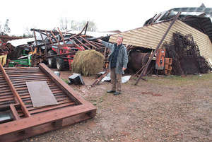
Fred Martin Jr. gestures at damage to a machinery storage building and hay barn severely damaged by Tuesday’s storm. His father estimated the damage would top $1 million.
A pounding storm that hammered the area early Tuesday left a path of damage from one end of Henry County to the other.

In the Dyers Store area in eastern Henry County, Fred Martin Sr. initially estimated the damage at his Martin Stables at between $600,000 and $800,000 but later raised that to "way more than $1 million," considering all the vehicles that were damaged.

A machinery storage building, hay barn and half a cinderblock building were destroyed, left in a pile of rubble in the storm that hit around 2 a.m. Tuesday. Some of the buildings had been there for 40 to 50 years, Martin said.

His son, Fred Martin Jr., said the company's machinery lay beneath the rubble. Martin Sr. said the vehicles that were licensed for road use and his home nearby were insured; the buildings at the stables were self-insured. One furniture van alone was worth $60,000, he said, adding that one building held 12 farm tractors.
Cloud Lightning

Namibia: 62 killed, thousands displaced by floods as more rain expected

The United Nations says 62 people have been killed and thousands forced from their homes since the start of the year by flooding in northern Namibia.

In a statement Wednesday, the U.N. children's fund says the numbers could "dramatically increase" soon.

U.N. officials in Namibia say a new wave of water is expected from Angola, and the forecast is for more rains in northern Namibia in the coming days.

UNICEF says northern Namibia is already vulnerable. It is among the most densely populated and poorest parts of the country, with a high number of people carrying the AIDS virus. UNICEF says one in every fifteen children dies before reaching the age of five in the region.

Umbrella

Kenya: Heavy Rains Expected This Month

Most parts of the country will receive improved rains for the rest of the month. Weathermen yesterday said the resurgent rains will spread countrywide but will be interrupted by sunny intervals within the month.

The month-long forecast shows most places will receive near-average rainfall, except North Eastern where rains will be depressed and poorly distributed.

This will ease the current drought and improve electricity supply. "April is the peak month of the long rains season. The rain-bearing belt traverses the country from South to North during the month," said director of meteorological services Dr Joseph Mukabana.

Bizarro Earth

US: Fish Kills Another Legacy of Long, Snowy Winter


Plymouth, Minnesota -- Like a lot of Minnesotans, Bruce Wahlstrom was happy to see the ice disappearing from his lake he lives on.

Then, he noticed what was underneath.

"I actually saw it last night as the ice started to melt back," said Wahlstrom. "This morning, it's just tons of dead fish."

Hundreds of dead fish are washed up on Wahlstrom's property on Schmidt Lake in Plymouth, or floating in the shallow water. He knows the recipe for a fish kill: Early, heavy snow piles up on the ice, making it impossible for sunlight to reach the bottom of a lake. The lack of natural light then keeps plant life from creating oxygen. If the winter is long enough, and the heavy snow lasts, fish eventually run out of oxygen to breathe and die.

Attention

Stromboli: Series of Explosions and Landslides

Stromboli Volcano_01
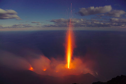
© Volcano Discovery300 m tall, candle-like eruption from the central crater of Stromboli
Sicily - There has been a concerted series of explosions and landslides on Stromboli. Over the last 24 hours, monitors at the Vesuvian Observatory have picked up fifteen seismic signals associated with mild landslide events, all along the Sciara del Fuoco (Stream of Fire). Most of these events were follow-ons to the explosions and can therefore be attributed to rolling debris.

Comment: Latest recorded seismic activity around Sicily, Italy:

3 shakes and minor landslides, Feb. 18 - Stromboli
5 shakes and minor landslides, Feb. 22 - Stromboli
5 shakes and minor landslides, Feb. 28 - Stromboli
2.6 and 2.7, Mar. 4 - (Sea-quake) Porto Palo di Capo Passero, Ionio Sea
2.6 and 3.7, Mar. 9 - Messina, Sicily
2.1, April 2 - Messina, Sicily

(A 6.1 magnitude one was recorded in Greece on April 1)


Bizarro Earth

US Geologists: Newberry Volcano is still a threat

Image
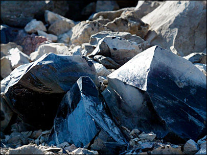
© Associated PressObsidian lava rocks at Newberry National Volcanic Monument in Oregon.
When Newberry Volcano south of Bend last erupted 1,300 years ago, gas trapped in sticky magma exploded from the caldera south of Bend, flinging pumice and ash more than 3,000 feet up into the air. As the volcanic gases settled down, flows of lava oozed out, quickly cooling into the glassy Big Obsidian Flow.

About 7,000 years ago, magma spread north from Newberry through a crack in the rock, erupting to form the Lava Butte cinder cone.

And with the magma still heating rocks under Newberry Volcano, geologists expect more eruptions to shake the area in the future.

"It's still hot under there," said Julie Donnelly-Nolan, a research geologist with the U.S. Geological Survey's Volcano Science Center in Menlo Park, Calif. "We have no reason to believe it's finished."

Because of this, the USGS is planning to add eight seismic monitoring stations next summer on Newberry Volcano, which the agency classifies as a "very high threat."

Igloo

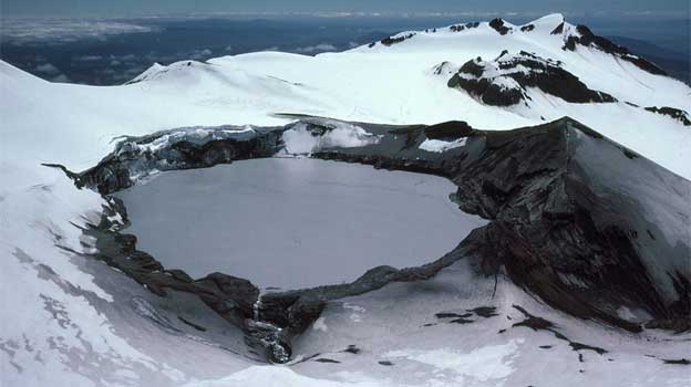
New Zealand: Aviation alert at Mt Ruapehu as first dump of season falls

Image
© UnknownMt. Ruapehu
Aviation authorities have issued alerts to planes flying over Mt Ruapehu due to the volcano's crater lake sustaining a prolonged hot phase.

In addition to the high water temperature, other signs of volcanic unrest have been recorded by vulcanologists including changes in volcanic gas output, seismic activity and crater lake water chemistry.

However, despite the changes in volcanic activity, there were no indications an eruption was on its way, GNS Science volcano surveillance co-ordinator Brad Scott told the New Zealand Herald.

He said the volcanic alert level remained at level one, which meant there were signs of volcanic unrest.

But it is an active volcano and future eruptions may occur with little or no warning.

Radar

Record loss of ozone over Arctic

Image
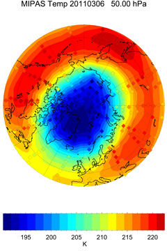
© University of BremenArctic temperature field for 6 March 2011 when ozone depletion started. This field was derived from MIPAS measurements at 50 hPa.
ESA's Envisat satellite has measured record low levels of ozone over the Euro-Atlantic sector of the northern hemisphere during March.

This record low was caused by unusually strong winds, known as the polar vortex, which isolated the atmospheric mass over the North Pole and prevented it from mixing with air in the mid-latitudes.

This led to very low temperatures and created conditions similar to those that occur every southern hemisphere winter over the Antarctic.

As March sunlight hit this cold air mass it released chlorine and bromine atoms - ozone-destroying gases that originate from chlorofluorocarbons (CFCs) and break ozone down into individual oxygen molecules - predominantly in the lower stratosphere, around 20 km above the surface.

Ozone is a protective atmospheric layer found at around 25 km altitude that acts as a sunlight filter shielding life on Earth from harmful ultraviolet rays, which can harm marine life and increase the risk of skin cancer and cataracts.

Nuke

U.S. Sees Array of New Threats at Japan's Nuclear Plant

Fukushima Daiichi
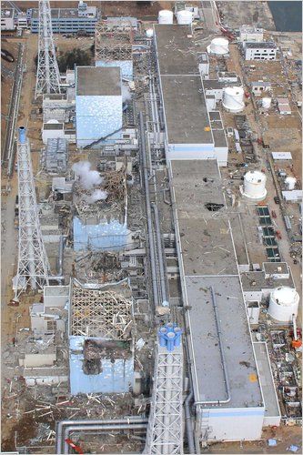
© ReutersWorkers at the Fukushima Daiichi nuclear station are dealing with new challenges.
United States government engineers sent to help with the crisis in Japan are warning that the troubled nuclear plant there is facing a wide array of fresh threats that could persist indefinitely, and that in some cases are expected to increase as a result of the very measures being taken to keep the plant stable, according to a confidential assessment prepared by the Nuclear Regulatory Commission.

Among the new threats that were cited in the assessment, dated March 26, are the mounting stresses placed on the containment structures as they fill with radioactive cooling water, making them more vulnerable to rupture in one of the aftershocks rattling the site after the earthquake and tsunami of March 11. The document also cites the possibility of explosions inside the containment structures due to the release of hydrogen and oxygen from seawater pumped into the reactors, and offers new details on how semimolten fuel rods and salt buildup are impeding the flow of fresh water meant to cool the nuclear cores.

In recent days, workers have grappled with several side effects of the emergency measures taken to keep nuclear fuel at the plant from overheating, including leaks of radioactive water at the site and radiation burns to workers who step into the water. The assessment, as well as interviews with officials familiar with it, points to a new panoply of complex challenges that water creates for the safety of workers and the recovery and long-term stability of the reactors.

Question

Cloudy with a chance of... doughnuts: The mysterious weather rings that are being picked up by radar

It looks like a giant doughnut is descending on northern Europe, or even a huge UFO.

But fear not, aliens have not invaded Belgium.

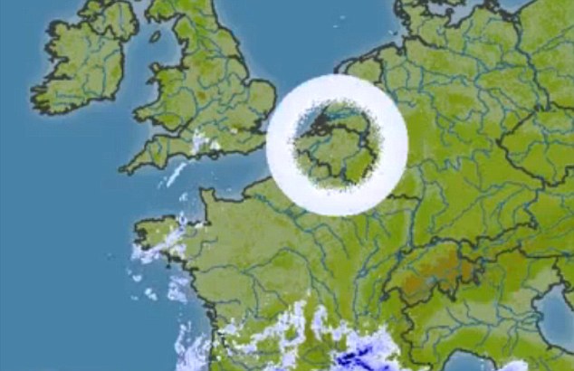
These circular cloud formations on weather radar images are in fact caused by freak weather conditions disrupting radar antennae.

Image
© UnknownAnomaly: The doughnut shaped cloud appears to be hovering over Belgium but the image is in fact caused by melting snow in the atmosphere affecting weather radar antennae
The rings are only visible on radar screens and are caused when snow melts in the atmosphere and bounces back the radar signal.

That causes the white ring that stretches out to limit of the radar's range. The clear inside of the ring is dependent on the angle at which the radar aerial points at the sky.