Earth ChangesS


Meteor

Best of the Web: Cosmic Climate Change: Space Shuttle Discovery - STS 131 leaves spectacular dragon trails in the sky

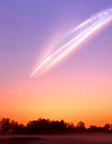
Space shuttle Discovery left Earth this morning at 6:21 am EDT in a spectacular dawn launch from Cape Canaveral. The combination of sunrise colors and the comet-like appearance of the departing shuttle astonished onlookers. "It was an awesome sight," says Michael Fertic, who sends this picture from Spring Hill, Florida:
Image
© Michael FerticThe sky is changing; more evidence that our upper atmosphere is loaded with comet dust

The show continued even after the shuttle was out of sight. Tiny ice crystals in Discovery's lingering exhaust caught the rays of the rising sun and formed an artificial noctilucent cloud of startling brightness. Even veteran observers were impressed. "It was the most incredible launch I have ever seen," says long-time shuttle watcher and part-time NASA medic Dr. Mark Staples of Shands Hospital. "Definitely, it was one of the most spectacular!" agreed Jim Burchfield of nearby St. Cloud, Florida. And Terry Allshouse of Leesburg, Florida, ranked it as "the best of the ten I have witnessed." More images of the launch from photographers:

Comment: Remember this?

Image
© Rex FeaturesStrange spiral: Residents in northern Norway were left stunned after the lightshow, which almost looked computer-generated, appeared in the skies above them
The Russian ICBM launch failed, forcing the rocket into a spin as it burned through the atmosphere.

The meteor that turned night into day in Utah, Idaho and Nevada last November left a "noctilucent", or night-shining trail suspended in the space-dust laden sky, which high altitude winds later twisted into this spaghetti formation:

meteor's aftermath
© SLTrib/ Les AshwoodA photo believed to be depicting the meteor's aftermath, taken at 7 a.m. Wednesday, Nov. 18, 2009, from Clive, in western Tooele County, looking east toward Salt Lake City.


Bizarro Earth

US: California/Mexico Border Still Shaking - Latest is 5.1 Magnitude Earthquake

Aftershocks from Easter's magnitude-7.2 earthquake in Baja California were felt in San Diego County today.

As of 4:15 a.m., the U.S. Geological Survey said five earthquakes stronger than magnitude-5.0 and dozens of smaller temblors have been recorded since yesterday's main event, which was struck about 3:40 p.m. and was centered 37 miles south-southeast of Mexicali. As of this morning reports indicate at least two people had been killed and about 100 injured.

On Sunday, reports indicated minor damage around San Diego County included jammed exit doors, water leaks, cracked walls and broken windows, authorities said.

A Julian resident got a lump on the head when something was shaken off a shelf in a store, and person was hurt when he fell while running out of his Chula Vista home.

Pat Abbott, a professor emeritus of geology at San Diego State University, said San Diegans should brace themselves for perceptible aftershocks for at least 72 hours after the initial quake.

Comment: Hundreds of aftershocks have occurred in less than 24 hours. See a complete list from USGS here.


Bizarro Earth

US: Police patrol quake-damaged California border town

Image
© AP Photo/Jorge RiveraThis photo provided by Jorge Rivera aka 'cimarron98' via Twitter shows structural damage to the Escomex business school building after an earthquake in Mexicali, Mexico, Sunday, April 4, 2010. The 7.2-magnitude quake struck at 3:40 p.m. in Baja California, Mexico, about 19 miles southeast of Mexicali, according to the U.S. Geological Survey.
Calexico - Inspectors found a landscape of smashed windows and caved-in roofs in this struggling border city's historic downtown on Monday after a deadly Easter earthquake in nearby Mexico.

The 7.2-magnitude temblor struck just south of the U.S. border near Mexicali, killing two people and destroying dozens of businesses and homes there and severely injuring another in the neighboring California town of El Centro.

In Calexico, the hardest-hit U.S. city, the quake damaged nearly 80 percent of the city's historic downtown area, authorities said. Three tanks holding the city's water supply were damaged, City Manager Victor Carrillo said.

City officials asked residents to limit water use to essential bathing, cooking and washing.

The quake was the latest blow to a region struggling with the state's highest unemployment rate, said Hildy Carrillo, executive director of the Calexico Chamber of Commerce.

Info

NOAA SEC Space Weather Advisory Bulletin #10- 1: Strong Geomagnetic Storm in Progress

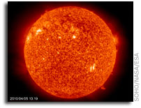
Solar Flare
© SOHO/NASA/ESA
Official Space Weather Advisory issued by NOAA Space Weather Prediction Center
Boulder, Colorado, USA

SPACE WEATHER ADVISORY BULLETIN #10- 1
2010 April 05 at 12:13 p.m. MST (2010 April 05 1213 UTC)

**** STRONG GEOMAGNETIC STORM IN PROGRESS ****

A geomagnetic storm began at 05:55 AM EST Monday, April 5, 2010. Space weather storm levels reached Strong (G3) levels on the Geomagnetic Storms Space Weather Scale. The source of the storming is an Earth-directed Coronal Mass Ejection associated with a weak solar flare that occurred in Active Region 1059 on April 3 at 05:54 AM EST. This is expected to be an isolated storm that should subside quickly. Other than the flare and CME erupting on April 3, this active region has not produced any significant activity. Systems that can be affected include electric power systems, spacecraft operations, high-frequency communications, GPS, and other navigation systems.

Data used to provide space weather services are contributed by NOAA, USAF, NASA, NSF, USGS, the International Space Environment Services and other observatories, universities, and institutions. More information is available at SWPC's Web site

Bizarro Earth

Mozambique: Earthquake in Angoche Injures 59

Maputo - An earthquake of a magnitude and epicentre not yet determined hit the district of Angoche, in the northern Mozambican province of Nampula on Friday, injuring 59 people.

According to the independent television station STV, besides the injured people, the quake also damaged several buildings, including the local registry office.

Angoche mayor Americo Adamugy, cited by Radio Mozambique, said the earthquake had caused no fatalities.

This earthquake comes a few days after a small tremor hit Chimoio, the capital of the central province of Manica, and some surrounding districts.

Recorded at about 14:00 hours on 30 March, the Manica quake lasted 30 seconds, and was of a magnitude of four on the Richter scale. It did no significant damage, but shook some buildings and caused panic among local residents.

Bizarro Earth

Small earthquakes occurring on Alaska volcano

Anchorage - A volcano near Anchorage could be waking up.

The Alaska Volcano Observatory says a series of small earthquakes began occurring early Monday near the summit of Mount Redoubt, about 100 miles southwest of Anchorage.

Scientists do not know if the earthquakes will result in the volcano becoming explosive, but they say there is a heightened possibility. Last year, the volcano was very active for months, at times producing huge ash plumes and sending mud flows down its flanks.

Rick Wessels, a geophysicist with the U.S. Geological Survey, says the Mount Redoubt earthquakes are not connected to Sunday's 7.2-magnitude quake in Mexico just south of the U.S. border because the distances are too great.

Bizarro Earth

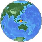
Magnitude 6.2 - Molucca Sea, Indonesia

Earthquake Molucca
© USGSEarthquake Location
Date-Time:
Monday, April 05, 2010 at 10:05:42 UTC

Monday, April 05, 2010 at 07:05:42 PM at epicenter

Location:
0.169°S, 125.012°E

Depth:
10 km (6.2 miles) set by location program

Distances:
185 km (115 miles) S of Manado, Sulawesi, Indonesia

230 km (140 miles) ESE of Gorontalo, Sulawesi, Indonesia

1500 km (930 miles) NNW of DARWIN, Northern Territory, Australia

2130 km (1320 miles) ENE of JAKARTA, Java, Indonesia

Bizarro Earth

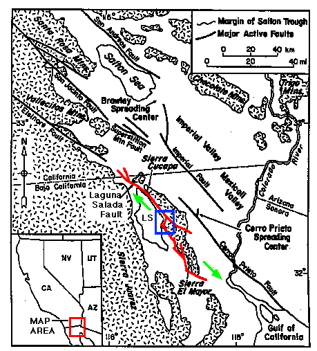
Big Baja quake came from 'chaotic' fault system

Image
Los Angeles - The strong earthquake that rocked Baja California on Sunday probably occurred on a fault that hadn't produced a major temblor in over a century, scientists said.

Preliminary data suggest Sunday's 7.2-magnitude quake originated on the Laguna Salada fault, which stretches 43 miles along the U.S.-Mexico border. The last time it unleashed a similar-sized quake was in 1892. Since then, the fault has produced occasional magnitude-5 temblors.

In recent days, Baja California's wine-growing region west of the epicenter has been rattled by small quakes between magnitudes 3 and 4.

Whether they were foreshocks to the deadly magnitude-7.2 that struck 38 miles south of Mexicali is not yet known.

"It's such a chaotic system" of faults that needs more researching, said Erik Pounders, a geologist with the U.S. Geological Survey.

The Baja quake appeared to have ruptured about 30 miles of the fault, stopping at the border. Dozens of aftershocks were recorded on both sides of the border within hours of the quake with the largest registering 5.4.

Target

Quake hits U.S.-Mexico border

A powerful 7.2-magnitude earthquake rocked the U.S.-Mexico border region Sunday, causing power outages in both countries as it sent out seismic waves felt from Los Angeles to Arizona and Tijuana.

The quake happened at 3:40 p.m. PT in the Mexican state of Baja California, about 60 kilometres southeast of Mexicali, the state's capital city, according to the U.S. Geological Survey. The area has been hit by 3.0-magnitude quakes all week.

More than 900,000 people live in the greater Mexicali area.

Bizarro Earth

Hawaii: Cold Records Fall on 3 Islands

The Easter bunny may be hopping cold these days as winter-like temperatures, created by cool, northerly winds, continue to plague the Islands for the third consecutive day.

This morning's low temperature broke three records for this date.

It was 59 degrees at Honolulu Airport at 6 a.m. breaking the 19-year record of 61 degrees. Yesterday's low at the airport also set a record.

Kahului Airport on Maui was downright chilly this morning where a 54-degree reading was recorded. The previous record was 57 degrees.

This morning's record low also was the lowest temperature ever recorded in April at Kahului.

Hilo Airport on the Big Island was 61 degrees, breaking by 1 degrees the low reading recorded in 1959, 1965, 1973 and 1981.

Lihue Airport on Kauai recorded a 60-degree reading, a degree above its record low for this date.