Earth ChangesS

Igloo

US: Manitowoc, Wisconsin area under winter storm warning, 6 inches possible

The National Weather Service out of Green Bay has issued a winter storm warning for the Manitowoc area starting at 1 p.m. today until 10 a.m. Wednesday.

According to its forecast:

A band of snow is expected to produce 6 or more inches of wet packing-type snow today and tonight. Locations near Lake Michigan may see lower amounts due to warmer temperatures. The snow also may mix with sleet and light rain at times, lessening the accumulation.

Heavy snow can cause travel to become extremely hazardous as roads become snow or ice covered. Heavy snow also could reduce visibilities to a quarter of a mile or less at times.

"You just have to be cautious and slow down because the snow is so wet and heavy. When the roads are slushy, it pulls you into a ditch, that's why you have to be careful," said Gary Kennedy, Manitowoc County Highway Commissioner.

Snowman

Wisconsin, US: Slush and Snow Sticking Around into Wednesday

Image
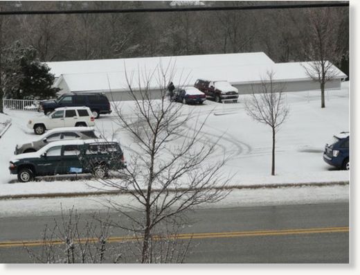
© Lyssa BeyerSnow fell on Port Washington despite the fact that April is almost over, covering cars in white and forcing drivers to bust out their scrapers.
Port Washington and Saukville are covered in white again after a wintry storm Tuesday.

The National Weather Service predicts a 100 percent chance of precipation in Port Washington and Saukville as we look into the overnight hours.

Tonight, residents can expect "rain showers, possibly mixed with snow and sleet before 10 p.m.; then rain, possibly mixed with snow showers between 10 p.m. and 1 a.m.; then periods of snow after 1 a.m," according to the National Weather Service. Thunder is also possible tonight, and has already been heard throughout the area this afternoon.

Will it be over by Wednesday? Well, maybe.

Evil Rays

Enormous amount of high-level radioactive waste coming from Unit No. 2 - Reactor and containment are breached

Arnie Gundersen interview, Democracy Now, April 19, 2011:

Transcript Excerpts

Amy Goodman: Can you talk about TEPCO saying that they were optimistic that they could bring down radiation at the damaged plant and go to a cold shutdown of the facility in six to nine months? ... Will radiation be leaking for the six to nine months?

Arnie Gundersen: Radiation is leaking every day now, both liquid into the ocean and also airborne. When you see those clouds of smoke coming out of the unit, that's not steam, that's radioactive steam. So, they're releasing radioactivity as a airborne, and also, probably more important right now is Unit 2, the reactor has a hole in it, and the containment has a hole in it. So they're pouring water in the top, and it's running out the bottom. And it's what's causing all of this enormous amount of high-level radioactive waste. ...

Phoenix

US: Crews battle fierce fire west of Fort Worth, Texas

Dallas - State officials said Tuesday that a wildfire burning about 70 miles from the Dallas-Fort Worth area has blackened an area twice as big as previously estimated, and that strong wind gusts and hot temperatures would make it tougher to fight the blaze.

Fish

California: Hundreds of dead fish found in Ventura Harbor

Ventura Harbor -- Hundreds of fish have been found dead in Ventura Harbor. This is the second large fish kill in Southern California this year. This time, hundreds of dead fish are floating in Ventura Harbor.

http://cdn.abclocal.go.com/static/flash/embeddedPlayer/swf/otvEmLoader.swf?version=&station=kabc&section=&mediaId=8081042&cdnRoot=http://cdn.abclocal.go.com&webRoot=http://abclocal.go.com&configPath=/util/&site=

The phone calls started coming into the Ventura Harbor Patrol around 6 a.m. Monday. Boaters were already noticing a large number of dead fish floating in the water. One officer said that in the past year, there have been three or four times that this has happened, and in recent days, he was worried that this was going to happen again.

Once again, something's fishy along our Southern California coastline: Another fish die-off, this one in the Ventura Harbor.

Snowman

Canada: Record breaking snow for Calgary

Image
© unknown
Calgary smashed a one-day snowfall record on Thursday -- breaking a record that's been holding strong for 110 years.

Does April snow bring May flowers?

Calgary residents are probably wondering what happened to spring after 23 cm was noted at Calgary International Airport on Thursday -- breaking the record for the most snowfall on April 14. The last time the city saw that much of a wallop on the same day was back in 1901 (17.8 cm).

Other areas throughout the city actually saw upwards of 30 cm pile up.

According to Environment Canada, a weather disturbance from BC moved into southern Alberta on Wednesday evening, bringing heavy snow into the foothills.

Despite the fact the calendar says April, other parts of Alberta also reported accumulations including: Edmonton International Airport (8 cm), Red Deer (11 cm), Lethbridge (6-17 cm), Cochrane (10-12 cm) and Stony Plain (16 cm).

Although it's spring, this type of weather isn't unusual for Alberta. "Some of the highest snow totals for Calgary happen in April and May, which is why this isn't a shock for residents," says Rob Davis, another meteorologist here at The Weather Network.

Phoenix

New Zealand: Ruapehu activity slowing but still elevated

Image
© Ray MaxwellEarly winter snow on Mt Ruepehu
Volcanic activity on Mt Ruapehu appears to be slowing according data monitored by GNS Science.

While activity seems to be decreasing overall, and there are no data to suggest an imminent eruption, the volcano remains in a state of elevated unrest above the typical background level.

The Aviation Colour Code remains at Yellow and the Volcanic Alert Level remains at Level 1.

The temperature of Crater Lake is down to around 33-34C from a peak of 41C in March 2011.

Bizarro Earth

US: Tornadoes, flash floods, hail tear through six states; 39 people dead

Image
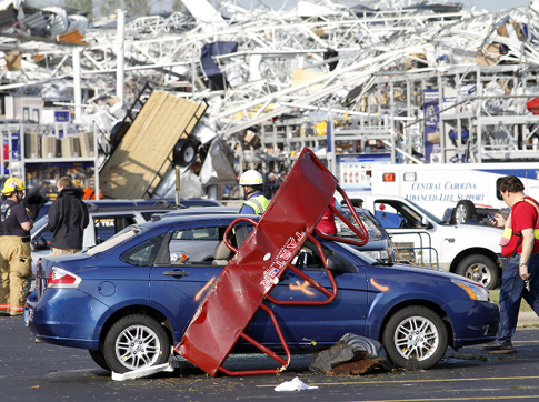
© Jim R. Bounds/APEmergency personnel work around a Lowes Home Improvement store after it was hit by a tornado in Sanford, N.C., Saturday.
The massive storm system ripping through the South had killed 39 people in six states as of Sunday morning, and the death toll was expected to rise.

The wave of tornadoes, flash floods and chunks of hail began in Oklahoma on Thursday, killing people there before it claimed lives in Alabama, Arkansas, Oklahoma, Mississippi and North Carolina.

North Carolina's governor declared a state of emergency after 62 tornadoes touched down, the most in two decades.

Ten people were already confirmed dead in Bertie County, a hamlet of 21,000 people about 130 miles east of Raleigh, North Carolina, county manager Zee Lamb said.

The tornado crashed through at about 7 p.m. on Saturday, destroying homes and sending cars flying through the air as they drove along the county's small rural roads.

Info

US: Mississippi River hits 19 feet

At mid-day, the Mississippi River is at 19 feet in the Quad-Cities and is projected to hit 20.5 feet by Friday, according to the latest information from the National Weather Service.

That would make it the 6th worst floods in Quad-City history.

Watch out for detours along flood-prone areas in Moline and Davenport.

At 20 feet water is over the top of the jetty at Lindsay Park Yacht Club in Davenport and affects buildings at Sunset Marina in Rock Island. Water also affects the Quad-City Sports Center and in Davenport and Moline River Drive from the 2300 to 5500 block. Water is at the foundations of Davenport's Union Station and Freight House buildings.

At 19 feet, water affects Rock Island's Sunset Marina parking lot and from 2700 to 4800 River Drive in Moline. LeClaire Park in Davenport is entirely underwater and water is over most of River Drive from Division to Federal streets. Water is also at the base of the loading docks of the 2nd Street Post Office in Davenport.

Bizarro Earth

US: After Storms, a Path of Death and Damage

Image
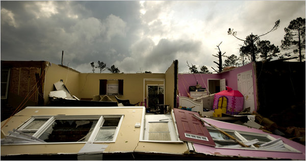
© James Robinson/The Fayetteville Observer, via Associated PressA tornado ripped apart a home in Fayetteville, N.C. At least 23 people were reported dead throughout the state.
The reality of the devastation of a storm that sent more than 200 tornadoes ripping across the South, killing at least 45 people and causing millions of dollars in damage, began to sink in Monday morning.

In North Carolina, where the storm killed at least 23 people and put hundreds in the hospital, federal and local emergency workers were fanning out to the areas hardest hit and residents were scrambling to figure out how to help their neighbors or, for the dozens who lost their homes, how to start over.

In the Raleigh area, the police kept residents from a mobile home park with about 200 homes where three young siblings were killed. In sections of this city of about 400,000, several major buildings were damaged and several schools and government offices were closed for the day. Traffic into downtown Raleigh was snarled.

In rural areas, downed cellphone towers and severed utility lines were likely to hamper clean-up efforts.

The storm, which began Wednesday in Oklahoma and charged east for the rest of the week, brought winds as high as 165 miles per hour and spread challenging weather from New York to South Carolina.