Earth ChangesS


Cloud Lightning

US: Tornado warning in St. Louis after 14 killed in 3 states

Kansas City area earlier saw twisters; several states on alert
Image
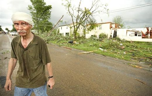
© Sydney Brink/The Sedalia Democrat/APJoe Horacek of Sedalia, Mo., surveys the damage shortly after a tornado sliced through his neighborhood Wednesday. Horacek said he got sprayed with glass and debris when he looked out a window and barely made it to the safety of his bathroom. His home, in background, he said, "is gone."
Kansas City, Missouri - As residents in three states picked through rubble, looking for victims and belongings buried by storms that killed 14 people, twisters hopped across the Kansas City area Wednesday while a tornado warning was issued for St. Louis, where a trained spotter reported a twister briefly touched down near a busy interstate.

Funnel clouds were seen across the St. Louis area, NBC affiliate KSDK-TV reported.

The system also caused Chicago's O'Hare airport to cancel 550 flights and delay inbound and outbound flights by three hours.

Suburbs around Kansas City, Mo., reportedly saw at least one twister, and the National Weather Service issued a tornado warning for the downtown area, where a a rotating wall cloud was seen before the weather improved.

No reports of damage were immediately available but tornado sirens were heard in some areas. People in downtown buildings moved into underground areas before the worst of the weather passed.

A tornado also touched down in nearby Sedalia, Mo., the National Weather Service said. A Sedalia resident told KSHB-TV that damage in the town of about 21,000 was significant.

Earlier Wednesday, a twister was reported on the ground in Miami County, Kan., just west of Kansas City. Damage was spotted near Highway 69, KSHB-TV reported officials as saying.
Info

Japan Quake Raises Shaking Risk Elsewhere in Country

Japan Tremors
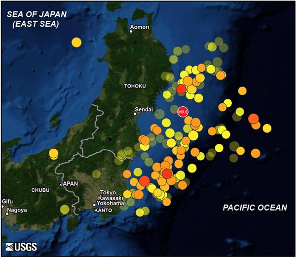
© USGSMap showing the 11 March 2011 magnitude 9.0 off Tohoku mainshock and 166 aftershocks of magnitude 5.5 and greater until May 20. Warmer color indicates more recent events. Larger symbol indicates greater quake magnitude.

The massive 9.0 magnitude earthquake that devastated Japan in March built up stress on other faults in the country, putting some areas, including Tokyo, at risk of aftershocks and even new main shocks over the next few years, scientists have found.

After studying data from Japan's extensive seismic network, researchers from the Woods Hole Oceanographic Institution (WHOI), Kyoto University and the U.S. Geological Survey (USGS) have identified several areas at risk from the quake, Japan's largest ever, which already has triggered a large number of aftershocks.

Data from the Tohoku earthquake on March 11 has brought scientists a small step closer to a better assessment of future seismic risk in specific regions, said Shinji Toda of Kyoto University, a lead author of the study.

"Even though we cannot forecast precisely, we can explain the mechanisms involved in such quakes to the public," he said. Still, he added, the findings do bring scientists "a little bit closer" to being able to forecast aftershocks.

Bizarro Earth

US: Little Missouri River reaches record high Tuesday, hydrologist calls it 500-year event

The stream flow of the Little Missouri River at Camp Crook reached a record high when the water level peaked, according to real-time U.S. Geological Survey stream-gage data.

The water level peaked at 19.42 feet on Tuesday, about seven feet above the National Weather Service designated flood stage of 12 feet.

"This event only had a 0.2 percent chance of occurring, making it a 500-year event," said Joyce Williamson, a USGS hydrologist. "This doesn't mean that the next comparable flood will be in 500 years, just that there is a 0.2 percent chance of this level of flooding to occur. Multiple 500-year events can occur in a short time frame and then not again for a very long time."

Cloud Lightning

"We are not in Kansas anymore?" Kansas, US: Storms wallop Rush County

Image
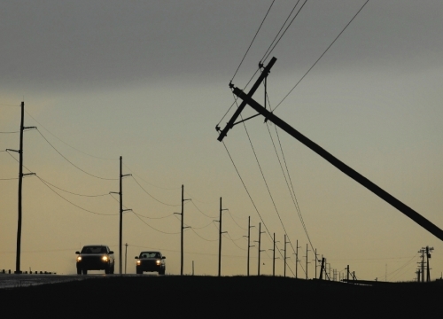
© Steven Hausler • Hays Daily NewsVehicles travel along U.S. Highway 183 as power poles are blown over Tuesday after a thunderstorm south of La Crosse
As the winds died down and the heavy rains slowed to a sprinkle, residents here started venturing out from their homes, curious what they might see.

What they found, surprisingly, was little damage, but an abundance of water in the streets along with trash cans.

"Lot of rain," said Lynn Enslinger, who retrieved a trash cart from the middle of the street. "We avoided the big disaster. We were lucky."

Fire trucks canvassed the city, driving up and down every street, checking for damage.

Rainfall amounts varied, but Rush County Emergency Management Director Jim Fisher suspected they were in the 4- to 5-inch range, all of it falling within an hour's time.

Image
© UnknownStormchasers watch a thunderstorm Tuesday in Rush County

Cloud Lightning

US: Heavy rains bring flooding to parts of Northeast Ohio Tuesday

Image
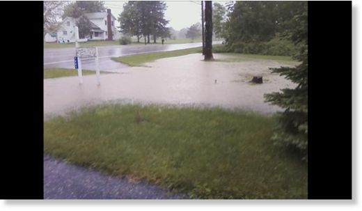
© AdamHeavy rains this afternoon in Atwater in Portage County.
A slow moving line of storms brought heavy rains to parts of Portage, Stark, Summit and Wayne Counties Tuesday evening.

The National Weather Service says that several areas have received over an inch of rain according to doppler radar estimates of 1.75" north of Massillon in Stark County and up to 1.25" north of Wooster in Wayne County.

In Portage County, street flooding was reported in Atwater shortly before 6 p.m. Tuesday evening.

A flood warning was issued earlier in the evening for Portage, Stark, Summit and Mahoning counties.

Cloud Lightning

Mother Nature isn't Happy! Texas, US: Rain, Hail Force Late Night in Arlington

The Rangers game with the White Sox was delayed for two hours and 58 minutes on Tuesday night at the Ballpark in Arlington.

During the delay, Rangers officials had to remove fans first from the upper deck and then the main concourse while dealing with the threat of heavy rains, lightning, hail and possible tornadoes.

The White Sox had a 4-2 lead going into the bottom of the fourth inning after Carlos Quentin hit two home runs and drove in four runs against Rangers starter Derek Holland.


The game started with thunderstorms and lightning in the area, and the Rangers evacuated the upper deck in the third inning because of concerns for fans' safety.

"That level doesn't provide a whole lot of protection," said Rob Matwick, the Rangers' vice president for ballpark operations.

Cloud Lightning

Montana, US: Heavy rain in Billings covers streets, causes rockfall at Rims

Image
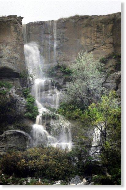
© James Woodcock/Billings Gazette A waterfall cascades off the rims east of North 27th Street Tuesday afternoon as heavy rains continue in Billings.
Heavy rain in Billings on Tuesday night covered streets around town with deep water and caused large boulders to fall from the Rimrocks onto Zimmerman Trail.

Zimmerman Trail is closed and water is pouring off the Rims in waterfalls.

Yellowstone County Sheriff's deputies and Montana Highway Patrol troopers closed down the intersection at First Avenue North and Main Street after the street flooded with more than a foot of water, which spilled up over the sidewalks.

Highway 87 North at Exposition Drive is closed.

All over the area east of downtown, cars stalled in the deep water, especially on Main and Fourth and Sixth avenues north, where manhole covers blew off because of the deluge. Fourth Avenue North is closed at North 24th Street.

The Sixth Street Underpass east of downtown has also flooded and should be avoided. At least one car has stalled there.

On the North Side, neighbors William Barber and Aaron Snyder nervously watched the the BBWA Canal, which runs behind their homes on the 1600 block of Vuecrest Drive.

Blackbox

Flashback Global Warming Will Bring Violent Storms And Tornadoes, NASA Predicts

Image
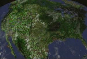
© NASA/NOAAClouds over North America on August 2, 2000, as measured by GOES-11.
NASA scientists have developed a new climate model that indicates that the most violent severe storms and tornadoes may become more common as Earth's climate warms.

Previous climate model studies have shown that heavy rainstorms will be more common in a warmer climate, but few global models have attempted to simulate the strength of updrafts in these storms. The model developed at NASA's Goddard Institute for Space Studies by researchers Tony Del Genio, Mao-Sung Yao, and Jeff Jonas is the first to successfully simulate the observed difference in strength between land and ocean storms and is the first to estimate how the strength will change in a warming climate, including "severe thunderstorms" that also occur with significant wind shear and produce damaging winds at the ground.

This information can be derived from the temperatures and humidities predicted by a climate computer model, according to the new study published on August 17 in the American Geophysical Union's Geophysical Research Letters. It predicts that in a warmer climate, stronger and more severe storms can be expected, but with fewer storms overall.

Comment: Please see our Connecting the Dots article: Earth Changes are Upon Us
Or any of our "Earth Changes" related pieces: Planet-X, Comets and Earth Changes by J.M. McCanney, Global Warming And The Corruption Of Science or any of the other several pieces in our Sott's Focus Section.


Bizarro Earth

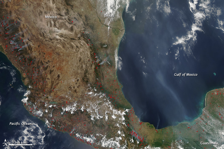
Busy 2011 Fire Season in Mexico

Mexico Fires
© Jeff Schmaltz, MODIS Rapid Response Team at NASA GSFC
May usually marks the end of the fire season in Mexico. Sometime during the month, the first wet-season rains begin to fall, followed by a soggy five months. Yet, on May 20, 2011, when the Moderate Resolution Imaging Spectroradiometer (MODIS) on NASA's Aqua satellite took this image, the fire season was still going strong. Fires, marked in red, were burning throughout the country, casting a smoky haze from the Pacific Ocean to the Gulf of Mexico.

The widespread fires shown here are evidence of the extreme fire season 2011 turned out to be in Mexico. By May 19, more than 530,000 hectares (1,300,000 acres or 2,000 square miles) of land had burned in the country since the beginning of the year, said the Mexican government. In terms of area burned, 2011 surpassed every year since (and including) 1998, making it one of the most challenging fire seasons in 30 years.

What made the 2011 fire season so extreme? In part, the answer lies in the 2010 rainy season, one of the wettest on record. Rains from Hurricane Alex flooded northern Mexico in July, and then torrential rains caused widespread flooding in southern Mexico in September. All of this excess water allowed thick grass to grow. During the dry season, which begins in October and lasts through May, the grass dried, providing ample fuel for fires.

X

Emirates cancels flights over Iceland volcano's ash cloud

Image
© Unknown
Dubai - Emirates has been forced to cancel two flights to Germany today due to the ash cloud caused by the volcanic eruption in Iceland.

Flights EK059 and EK060 between Dubai and Hamburg were grounded after the airspace in northern Germany was closed by authorities.

Passengers for these flights can rebook on to today's EK055 to Dusseldorf and the return flight, EK058, or travel tomorrow (May26).

According to the Emirates website, ground transportation will be provided between Hamburg and Dusseldorf.

The cancellations were announced as ash continues to be spewed out by the Grimsvotn volcano, which erupted on May 22.

"All other flights to and from the UK and Europe continue to operate as per the schedule," said the statement on the Dubai-based carrier's website.

"Emirates continues to monitor the situation closely, in addition to liaising with the relevant authorities regarding the movement of the volcanic ash cloud."

Flights operated by Etihad to and from the UK and mainland Europe are currently operating as scheduled but the airline said it was monitoring the situation.

"The airline is in close liaison with aviation experts, including the International Civil Aviation Organization (ICAO), Rolls-Royce and General Electric, and has been assured that the airspace in areas where it operates is open and safe to fly," the company said in a statement on its website.

Passengers for both airlines are urged to check the status of their flights on the respective airlines' websites.