Earth ChangesS

Cloud Lightning

US: Deadly tornado crashes through north Minneapolis

Powerful storm blew into metro, killing 1, injuring 30 and putting North Side under curfew.

Two days of threatening skies turned furious over the Twin Cities on Sunday, unleashing at least three tornado touchdowns in the metro area, killing one person in Minneapolis, injuring at least 30 others, knocking out power to thousands and leading to a curfew and school closings in north Minneapolis.

The massive, slow-moving storm also caused major damage in other metro communities, most significantly St. Louis Park and Fridley.

In the hardest-hit area, Minneapolis' Jordan neighborhood, downed trees, snapped power lines and pieces of roofs littered streets and yards. The smell of natural gas led police to call people out of some homes. Roads were blocked and residents scrambled to find loved ones; close to 200 or so people displaced by the storm made their way to an emergency shelter at the Northeast Armory, near Broadway and Central Avenue.

Mayor R.T. Rybak described the damage as "widespread and significant" after he and City Council President Barbara Johnson viewed it from a helicopter.

Recycle

US: Governor tours La Crosse tornado damage

La Crosse, Wis.- Gov. Scott Walker is in La Crosse to tour the damage caused by Sunday's tornado.

Walker says his heart goes out to everyone affected by the storm and says he's grateful no one was seriously injured. Walker toured damaged neighborhoods by car Monday afternoon.

At least 200 homes and businesses were damaged by the tornado, which was part of the same big storm system that spawned the deadly tornadoes around the Midwest.

National Weather Service meteorologist Glenn Lussky said preliminary assessments from field crews show the powerful storm was in fact a tornado and possibly an EF1.

Comment: Enhanced Fujita Scale: EF1 is an indicator on a scale of EF0-EF5. An EF1 scale Storm has sustained winds of 86 - 110MPH or 138 - 178km/h.

More info can be obtained here.


Cloud Lightning

Storm 'Chedeng' gathers strength as it hurtles toward Philippines

Image
© NasaReference Image, not actual.
Manila, Philippines - Tropical storm "Chedeng" continued to hurtle toward the Philippines with increased strength, threatening to become a "super-typhoon" and end the summer season with rolls of thunder and heavy rains, the state weather bureau said on Monday.

The Philippine Atmospheric, Geophysical, and Astronomical Services Administration (Pagasa) said Chedeng (international name: Songda) was seen to strengthen into a typhoon in the next 24 hours and bring strong winds, thunderstorms, and moderate to heavy rains all over the country.

Robert Sawi, Pagasa's chief forecaster, said Chedeng "is so far the strongest tropical cyclone to enter the country this year."

As of 10 a.m. on Monday, Pagasa said Chedeng, the third tropical cyclone of the year, was still at open sea, about 795 kilometers east of Guiuan, Eastern Samar.

It was carrying maximum sustained winds at 95 kilometers per hour near the center and gustiness of up to 120 kph. Sawi said Chedeng, which was moving west northwest at 15 kph, could reach over 100 kph in wind strength.

No storm warning signals were raised as of Monday afternoon, although Pagasa officials said they have advised local disaster coordinating councils to take appropriate actions.

Cloud Lightning

US: Tornado touches down in Medina

Image
© David JolesWyoming volunteer firefighter Joe Kuskey, center in white shirt, keeps a weary eye to the sky for funnel clouds near I-35.
A tornado touchdown was reported in Medina and a number of subsequent warnings sent residents bolting for their basements in the northern metro area on a storm-raked Saturday night.

There were no reports of injuries or serious damage from the touchdown, which was reported to the National Weather Service in Chanhassen by trained weather spotters.

But heavy rain and large hailstones slowed traffic and caused basement flooding and minor damage in the communities of Corcoran, Maple Grove, Osseo, Dayton, Rogers, Champlin, Coon Rapids, Anoka, East Bethel and Andover.

A Medina police officer said he saw a tornado tail hanging from the clouds at about 6:30 p.m., but it didn't appear to touch the ground. Sgt. Jason Nelson said hail fell and branches whipped back and forth, but he saw no tornado damage.

Radar

US: Missouri officials say tornado killed at least 89

Image
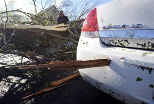
© UnknownA piece of wood is lodged in the bumper of a car after at least one tornado struck parts of north Minneapolis, causing extensive property damage, killing at least one person and injuring at least 18 others, Sunday, May 22, 2011.
Joplin, Mo. A massive tornado that tore a 6-mile path across southwestern Missouri killed at least 89 people as it slammed into the city of Joplin, ripping into a hospital, crushing cars like soda cans and leaving a forest of splintered tree trunks behind where entire neighborhoods once stood.

Authorities warned that the death toll could climb as search and rescuers continued their work. Their task was made more miserable Monday morning as a thunderstorm with strong, gusty winds and heavy rain pelted part of the city with quarter-size hail.

City manager Mark Rohr announced the number of known dead at a pre-dawn news conference outside the wreckage of a hospital that took a direct hit from Sunday's storm. Rohr said the twister cut a path nearly 6 miles long and more than a half-mile wide through the center of town, adding that tornado sirens gave residents about a 20-minute warning before the tornado touched down on the city's west side.

Much of the city's south side was leveled, with churches, schools, businesses and homes reduced to ruins. Fire chief Mitch Randles estimated 25 percent to 30 percent of the city was damaged, and said his own home was among the buildings destroyed as the twister swept through this city of about 50,000 people some 160 miles south of Kansas City.

Comment: On Earth Changes - From Where I sit: Rain drops keep falling on my head: "People are noticing and all this weather weapons nonsense is designed to make people think it's all a 'game'. The controllers want people to think they are in control because if people really could see that it is really all of the long-ago-predicted Earth Changes that we are experiencing NOW, they would turn on the governments and devour them."

- Laura Knight Jadczyk


Bizarro Earth

US: 'Cut the city in half': Death toll rises to 89 in Joplin, Missouri tornado

A massive tornado - the deadliest single U.S. tornado since 1953 - tore through the city of Joplin on Sunday, killing at least 89 people. Amid fears the death toll could climb, a fresh round of storms lashed the town early Monday, hampering search and rescue efforts.

City manager Mark Rohr announced the number of known dead at a pre-dawn news conference outside the wreckage of a hospital that took a direct hit from Sunday's storm. Rohr said the twister cut a path nearly six miles long and more than a half-mile wide through the center of town.


Much of the city's south side was leveled, with churches, schools, businesses and homes reduced to ruins.

Fire chief Mitch Randles estimated that 25 to 30 percent of the city was damaged, and said his own home was among the buildings destroyed as the twister swept through this city of about 50,000 people some 160 miles south of Kansas City.

"It cut the city in half," Randles said.

Phoenix

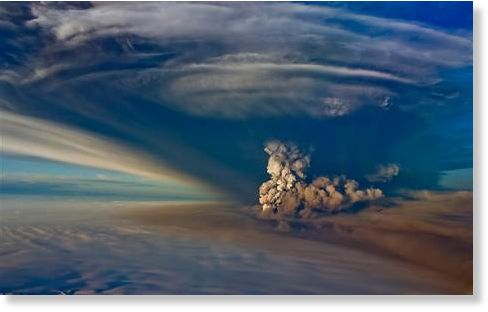
12-Mile-High Ash Plume Shutters Iceland Airports

Iceland Volcano
© Egill Adalsteinsson/EPA An aerial view shows the eruption of the volcano Grimsvotn in the south-east of Iceland.
More than a year after an Icelandic volcano wreaked havoc for millions of air travelers across the globe, a new eruption has spewed an ash plume 12 miles in the air. Iceland's airports have been shut down, and ash could affect Europe later this week.

Ash could reach northern Scotland by Tuesday and parts of Britain, France and Spain by Thursday or Friday if the eruption continues at the same intensity, airlines were warned on Sunday.

The warning is based on the latest 5-day weather forecasts, but is being treated cautiously because of uncertainties over the way the volcano will behave and interact with the weather.

The Grimsvotn (GREEMSH-votn) volcano, which lies beneath the ice of the uninhabited Vatnajokull glacier in southeast Iceland, began erupting Saturday for the first time since 2004, sending ash, smoke and steam 12 miles into the air.

It was the volcano's largest eruption in 100 years.

Cloud Lightning

US: Heavy Storms Maul Midwest, Leaving Deaths, Injuries, Destruction

A tornado flattened buildings, snapped trees and tossed tractor-trailers like toys as it touched down in Joplin, Missouri, on Sunday night, causing an unknown number of deaths and injuries.


The twister was part of a line of severe weather that swept across the Midwest on Sunday, prompting tornado watches and warnings that stretched from Wisconsin to Texas. High winds and possible tornadoes struck Minneapolis and other parts of Minnesota, leaving at least one person dead and injuring nearly two dozen others, police said.

Authorities in Joplin were contending with multiple reports of people trapped, as well as significant structural damage to St. John's Regional Medical Center, which was hit directly by the tornado, city officials said. CNN affiliate KSHB said there were reports of fires throughout the hospital.

Better Earth

Scotland: Pilot whales leave Loch Carnan following death

Image

A pod of more than 60 pilot whales, at risk of beaching, has again left a Hebridean loch after one of them died.

The animals had left the shallow waters of Loch Carnan in South Uist on Saturday, however returned during the night when the beaching took place.

A post-mortem examination suggested the young female died from a disease, not because it was stranded on rocks.

Comment: Scotland: Fear For Mass Stranding of Whales on South Uist


Magnet

Odd Twist In Slow 'Earthquakes': Mysterious Tremor Running Backwards Scientists Find

Earthquake scientists trying to unravel the mysteries of an unfelt, weeks-long seismic phenomenon called episodic tremor and slip have discovered a strange twist. The tremor can suddenly reverse direction and travel back through areas of the fault that it had ruptured in preceding days, and do so 20 to 40 times faster than the original fault rupture.

"Regular tremor and slip goes through an area fairly slowly, breaking it. Then once it's broken and weakened an area of the fault, it can propagate back across that area much faster," said Heidi Houston, a University of Washington professor of Earth and space sciences and lead author of a paper documenting the findings, published in Nature Geoscience.

Episodic tremor and slip, also referred to as slow slip, was documented in the Pacific Northwest a decade ago and individual events have been observed in Washington and British Columbia on a regular basis, every 12 to 15 months on average.

Slow-slip events tend to start in the southern Puget Sound region, from the Tacoma area to as far north as Bremerton, and move gradually to the northwest on the Olympic Peninsula, following the interface between the North American and Juan de Fuca tectonic plates toward Vancouver Island in Canada. The events typically last three to four weeks and release as much energy as a magnitude 6.8 earthquake, though they are not felt and cause no damage.