Earth ChangesS


Bizarro Earth

Chile: Earthquake Magnitude 6.6 - Offshore Maule

Chile Quake_140211
© USGSEarthquake Location
Date-Time:
Monday, February 14, 2011 at 03:40:10 UTC

Monday, February 14, 2011 at 12:40:10 AM at epicenter

Time of Earthquake in other Time Zones

Location:
35.433°S, 72.739°W

Depth
25.4 km (15.8 miles)

Region
OFFSHORE MAULE, CHILE

Distances
70 km (45 miles) NNW of Cauquenes, Maule, Chile

95 km (60 miles) W of Talca, Maule, Chile

140 km (90 miles) NNW of Chillan, Bio-Bio, Chile

290 km (180 miles) SW of SANTIAGO, Region Metropolitana, Chile

Igloo

India: Cold wave revives in Himachal Pradesh state due to rain and snow

Several areas in the higher reaches were cut off from the rest of Himachal Pradesh as the state experienced another spell of snowfall today reviving cold wave conditions. The hills and mountain passes including Lahaul and Spiti and Kinnuar have been experiencing moderate to heavy snowfall since last evening. Telecommunication services were badly disrupted in Lahaul and Spiti district, which was already cut off by road from rest of the state due to heavy snowfall.

Keylong in Lahaul recorded 45 cm of fresh snow while Killar in Pangi, Rohtang pass, Mari and Koksar recorded 70 cm to 90 cm of snow as snowfall was continuing. The key tourist resorts of Manali, Narkanada, Hatoo Peak, Sarahan and Sangla also experienced snowfall while Shimla, Kullu, Mandi, Solan, Sirmaur and other hilly areas were experiencing heavy rains accompanied by high velocity icy winds.

Manali recorded about 30 cm of snow this evening while the nearby Solang ski slopes were covered under 120 cm thick layer of snow bringing cheers to skiers.
Kalpa and Sangla in Kinnaur district recorded 30 cm of snow while Narkanada and Khara patthar in Shimla district had 20 cm of snow.

Bizarro Earth

Hawaii: Ground collapse on Maui island big enough for car to fall in

Image
Heavy rains on Maui in the Waiehu area caused the ground to collapse, right next to a road's shoulder.

The huge hole is between Makaala Street and Wailupe Drive.

The sinkhole is 15 feet deep and up to 40 feet wide; it's big enough for a vehicle to fall into.

Sources say it's affecting drainage, fiber optics cables, and a sewer main.

State workers and county public officials will discuss repair efforts on Monday. Drivers are advised that authorities may close a lane along Waiehu Beach Road when repairs begin.

Cloud Lightning

Cyclone Bingiza set to hit Madagascar

Image
Tropical Cyclone Bingiza east of northern Madagascar early on February 10
Madagascar is being lashed by heavy rains, and things are promising to get worse over the next few days.

Tropical Cyclone Bingiza is creeping ever closer. For the last few days it has been swirling a few hundred kilometers off-shore, with just the outer fringes of the storm thrown westwards towards the island. These outer bands have already brought a lot of rain, but the centre of the storm where the worst of the weather is, has not reached Madagascar yet.

Currently the eye of the storm has sustained winds of nearly 160kph, and gust of 195kph. This makes it the equivalent of a category 2 hurricane, but the storm is still expected to strengthen as it creeps slowly westwards.

The full force of Bingiza is expected to strike on Monday, near the town of Mananara Avaratra in the northeast. The town is home to over 30,000 people, with the majority relying on agriculature for their livelihood. A storm of this size will unleash damaging winds and flooding rains capable of tearing through the more rudimentary style of housing, as well as fields of crops.

Sun

Behemoth Sunspot 1158: Earth-directed eruptions are likely in the hours ahead

Sunspot 1158 is growing rapidly (48 hour movie) and crackling with C-class solar flares.

Image
© SDO/HMISunspot AR1158 is growing rapidly and poses a threat for Earth-directed C-flares.
The active region is now more than 100,000 km wide with at least a dozen Earth-sized dark cores scattered beneath its unstable magnetic canopy. Earth-directed eruptions are likely in the hours ahead.

Bizarro Earth

Getting Ready for the Next Big Quake in Nepal

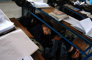
nepal earthquake drill
© EPA/Narendra ShresthaNepalese school children crouch under their desks during an earthquake drill at a secondary school on the outskirts of Kathmandu on Feb. 1 2010
In rows of benches with barely an inch between each other's crisp blue-and-red uniforms, the kids dutifully listen to their teacher's lesson. Once dismissed, they dash out, forming a bottleneck in the narrow passage that constitutes the hallway in this school in Kathmandu. Dozens of children fill each of the cramped rooms in the bare, crudely assembled three-story building. Most of the Nepalese capital's thousands of schools are housed in rudimentary, ill-maintained buildings, but this one happens to be uniquely sturdy. A few strategic vertical and horizontal strands of brick, fortified by steel-reinforced concrete, have been laid over the building's original adobe walls. It is among a small fraction of the South Asian nation's schools - or any private or public buildings, for that matter - designed to withstand a major earthquake.

This is not an abstract consideration. Nepal sits at the meeting point of the Eurasian and Indian tectonic plates, and the same seismic power that long ago produced the Himalayan mountain range continues to make the country an earthquake hotspot. Geologists have identified the region as due soon for a major earthquake, putting millions of people in danger and the nation's fragile economy at further risk. "The Kathmandu valley, unfortunately, has everything that Port-au-Prince has and more," says Robert Piper, the head of UN humanitarian operations in Nepal.

Working against the clock and with limited resources, a local NGO has been retrofitting a few dozen schools and hospitals in Kathmandu, and providing emergency response training to a few hundred more. The strands of brick and steel installed on the walls of the buildings act "like a rubber band," holding the structure together even if it were to sway, says Surya Prasad Acharya, an engineer with the National Society for Earthquake Technology (NSET). Though not pretty, NSET's renovations are simple, quick and cost-effective, which is crucial. Nepal is among the world's poorest countries (per capital GDP is $467) and its government has been largely dysfunctional in recent years because of infighting and civil strife.

Bizarro Earth

Chile: Earthquake Magnitude 6.0 - Off Coast of Bio Bio

Chile Quake_130211
© USGSEarthquake Location
Date-Time:
Sunday, February 13, 2011 at 10:35:06 UTC

Sunday, February 13, 2011 at 07:35:06 AM at epicenter
Time of Earthquake in other Time Zones

Location:
36.623°S, 73.165°W

Depth
13.3 km (8.3 miles)

Region
BIO-BIO, CHILE

Distances
25 km (15 miles) NNW of Concepcion, Bio-Bio, Chile

95 km (60 miles) W of Chillan, Bio-Bio, Chile

105 km (65 miles) SW of Cauquenes, Maule, Chile

420 km (260 miles) SSW of SANTIAGO, Region Metropolitana, Chile

Question

Outgassing? US: Mysterious odor stumps Maryland officials--Do you smell it?

Image
© Associated Press Photo/The Press of Atlantic City, Bill GrossResidents of Maryland and West Virginia smell rotten eggs.
A strange smell reminiscent of rotten eggs is pervading areas of Maryland and West Virginia, and state officials have no idea where it's coming from, reports WBALTV.

People in Montgomery, Prince George's and Frederick counties began calling in reports Wednesday that they had smelled mercaptan - a substance added to otherwise odor-free natural gas. Maryland officials then alerted the office of Jimmy Gianato, West Virginia's state director of Homeland Security and Emergency management, about a possible gas leak.

Info

Auroras Over Norway

How about a plane ticket to Norway? A solar wind stream due to brush past Earth's magnetic field around Feb. 14th could spark romantic lights around the Arctic Circle. Gabi and Gunter Reichert send this preview from Henningsvaer, a fishing village in Norway's Lofoten islands:

Norway Aurora
© Gabi and Gunter Reichert
Note the wildlife in the foreground. "We were taking pictures of the Northern Lights on Feb. 10th when this fox strolled right into our photo," say Gabi and Gunter. "He looked at us from a distance of 4 or 5 meters, yawned, and then laid down. We illuminated him with a little lamp to get this composite of green auroras with a red onlooker."

Aurora watchers red and otherwise should be alert for polar geomagnetic storms next week. Aurora alerts make a nice Valentine's Gift, too: text or voice!

Bizarro Earth

Tonga: Earthquake Magnitude 6.1 - 12th February

Tonga Quake_120211
© USGSEarthquake Location
Date-Time:
Saturday, February 12, 2011 at 17:57:56 UTC

Sunday, February 13, 2011 at 06:57:56 AM at epicenter

Time of Earthquake in other Time Zones

Location:
20.785°S, 175.589°W

Depth
81 km (50.3 miles)

Region
TONGA

Distances
55 km (35 miles) NW of NUKU'ALOFA, Tonga

290 km (180 miles) SW of Neiafu, Tonga

325 km (200 miles) E of Ndoi Island, Fiji

2010 km (1250 miles) NNE of Auckland, New Zealand