Earth ChangesS


Bizarro Earth

Tsunami-hit towns forgot warnings from ancestors

ancient tsumani warning
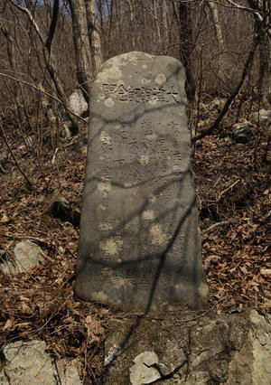
© AP Photo/Vincent YuIn this March 31, 2011 photo, A centuries-old tablet that warns of danger of tsunamis stands in the hamlet of Aneyoshi, Iwate Prefecture, northern Japan. Hundreds of such markers dot the coastline, some more than 600 years old. Collectively they form a crude warning system for Japan, whose long coasts along major fault lines have made it a repeated target of earthquakes and tsunamis over the centuries.
Modern sea walls failed to protect coastal towns from Japan's destructive tsunami last month. But in the hamlet of Aneyoshi, a single centuries-old tablet saved the day.

"High dwellings are the peace and harmony of our descendants," the stone slab reads. "Remember the calamity of the great tsunamis. Do not build any homes below this point."

It was advice the dozen or so households of Aneyoshi heeded, and their homes emerged unscathed from a disaster that flattened low-lying communities elsewhere and killed thousands along Japan's northeastern shore.

Hundreds of such markers dot the coastline, some more than 600 years old. Collectively they form a crude warning system for Japan, whose long coasts along major fault lines have made it a repeated target of earthquakes and tsunamis over the centuries.

The markers don't all indicate where it's safe to build. Some simply stand - or stood, until they were washed away by the tsunami - as daily reminders of the risk. "If an earthquake comes, beware of tsunamis," reads one. In the bustle of modern life, many forgot.

More than 12,000 people have been confirmed dead and officials fear the number killed could rise to 25,000 from the March 11 disaster. More than 100,000 are still sheltering in schools and other buildings, almost a month later. A few lucky individuals may move into the first completed units of temporary housing this weekend.
Bizarro Earth

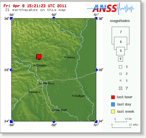
US: Earthquake Magnitude 4.2 - Arkansas

Image
© USGS
Date-Time:
Friday, April 08, 2011 at 14:56:32 UTC

Friday, April 08, 2011 at 09:56:32 AM at epicenter

Location:
35.261°N, 92.362°W

Depth:
6.3 km (3.9 miles)

Region:
ARKANSAS

Distances:
4 km (3 miles) NE (34°) from Greenbrier, AR

8 km (5 miles) SE (138°) from Twin Groves, AR

8 km (5 miles) SSW (200°) from Guy, AR

21 km (13 miles) NNE (23°) from Conway, AR

58 km (36 miles) N (357°) from Little Rock, AR

419 km (260 miles) SSW (207°) from St. Louis, MO

Bizarro Earth

Best of the Web: More Updates on Fukushima: Discussion of High Level Radiation Releases and the Previous "Worse Case Scenario" Planned for by the Industry

April 6, 2011: Arnie Gundersen discusses inconsistencies between what the NRC, TEPCo, and the Nuclear Industry are saying privately and publicly. Documents from the French nuclear firm, Areva, and the NRC reveal what the industry knows about the Fukushima disaster.


Umbrella

US: Storm Expected to Bring Snow and Rain To San Diego

A cold storm was expected to hit San Diego County late Thursday, bringing a chance of snow to the mountains and showers everywhere else, forecasters said.

According to the National Weather Service, a cold low pressure system moving southward along the west coast will bring much cooler weather today through Saturday.

"Snow levels could lower to near 4,000 feet for late Friday through early Saturday," the agency advised.

The Weather Service also advised that there was a slight chance of showers today but a greater chance of rain late Friday through early Saturday, along with a slight chance of thunderstorms as the coldest mid-level air moves across Southern California.

Rainfall totals from the storm were expected to be from up to a half-inch at the coast to about an inch on coastal mountains slopes.

Phoenix

Japanese volcano blows its stack

Geologists monitor latest eruptions at Sakurajima, which is sending large amounts of ash into the air

Japan's Sakurajima volcano, which has been regularly recorded blowing its stack since the 10th century, is at it again.

The volcano, located in the south of the country near the city of Kagoshima, is perhaps most famous for a 1914 eruption, which went into the record books as the most powerful of any in 20th century Japan.

The latest flare-up recently led the nation's meteorological agency to issue an ash warning for the Sakurajima volcano, now considered to be "very dangerous." But given what Japan has gone through these last several weeks, this is probably the least of the nation's worries just about now.

Bizarro Earth

Sea Turtle Deaths Mount in the Gulf

Sea turtles continue to wash ashore along the Gulf, forcing the National Marine Fisheries Service (NMFS) to scramble and figure out what is causing the spike. Last week, the Natural Resources Defense Council and The Huffington Post were first to publish blogs about the sea turtle deaths in Mississippi.

Since then, the national media picked up the story. Last Friday, NMFS released a statement with some details about its investigation:
In the past few weeks, we've seen an increase in turtle strandings in the northern Gulf, primarily in Mississippi. The spring time is the typical time when turtle strandings in this region begin to increase, but the sharp increases in recent days are of concern to us....NOAA Fisheries is in contact with the states of MS and LA regarding current trawl and other fishery activity that can result in turtle by catch and mortality. In addition, tests will be done for biotoxins, such as those from harmful algae blooms, which are common in the Gulf. ...All causes of death, including petroleum, will be investigated when possible based on decomposition. During a necropsy, the full GI tract is examined for product or evidence of oil ingestion. Additionally, samples are taken for PAH analysis. In addition, all turtles are being carefully examined for signs of external oiling.

Fish

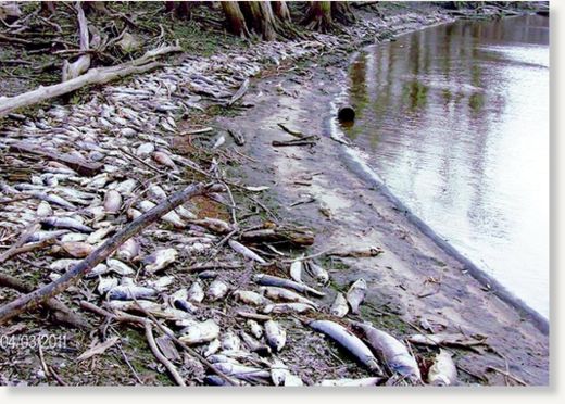
Iowa: Hundreds of dead fish line cove's banks

Image
Officials aren’t sure what caused this large fish kill along the Des Moines River and did not appear to be aware of it when contacted Wednesday.

Ottumwa - Why are there hundreds of dead fish lining the banks of a cove along the Des Moines River near Eddyville?

Local residents don't have that answer, but they did report the finned casualties to the Iowa Department of Natural Resources. One of them, Stephenie Dobson, reported the oddity to the Courier and sent along a photo on Facebook.

David Dobson of Eddyville said he likes to fish the area that's south of Hardfish Landing and west of the railroad trestle, both on the eastern side of the river.

Bizarro Earth

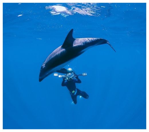
Dead Dolphins Spotted With Oil Washing up on Louisiana Shores

dolphin
Dead dolphins spotted with oil have been washing up in eastern Louisiana.(Courtesy of Gulf Coast Exploreum )

New Orleans - The National Oceanic and Atmospheric Administration says that eight months after the Deepwater Horizon oil well was capped, dolphins are washing ashore in east Louisiana with some oil from that spilled on their bodies.

Spokeswoman Kim Amendola says the dolphins had spots of weathered oil.

Blair Mase - NOAA's Gulf Coast stranding coordinator - emphasizes there's no way yet to know why the dolphins died. She says the most recent dolphin bearing BP oil was found two weeks ago.

Cloud Lightning

US: Forecast holds for busy storm season

The Colorado State University hurricane prognostication team has slightly lowered its prediction for this season.

On Wednesday, William Gray and Phil Klotzbach dropped from 17 to 16 the number of named storms - of tropical storm strength or higher - they expect will form.

The team stuck to its December forecast that nine of those would become hurricanes and five would grow to major hurricanes, of at least Category 3 on the Saffir-Simpson scale, with top sustained winds of at least 111 mph.

In 2010, the team's June prediction was 18 tropical storms, 10 hurricanes and five major storms. It was close: There were 19, 12 and five. The 1950-2000 average is 9.6, 5.9 and 2.3.

The team, which is in its 28th year of making predictions, never says how many or where storms will strike along the United States' 3,700-mile coast from Maine to Mexico.

But its new report gave a 48 percent chance - the norm is 31 percent - that a major storm will hit the East Coast, including peninsular Florida.

Cloud Lightning

Montana, US: Winter storm warning issued for Billings region

The National Weather Service in Billings has issued a winter storm warning for heavy snow from noon Thursday to 3 p.m. on Friday.

Rain and snow showers Thursday morning are expected to become more widespread and change to snow by this afternoon. Snow, which will be heavy at times, will continue overnight and early Friday, then decrease Friday afternoon.

Driving conditions could become difficult along Interstate 90 and Highway 89, the weather service said. Heavy wet snow also may cause falling power lines and endanger young livestock.

A winter storm warning means a significant amount of snow is expected or occurring. Strong winds also are possible.

The high temperature for Billings will be about 44 degrees Thursday with a low of 29 degrees. Friday's high is forecast to be 37 degrees while the low will be about 27 degrees.