Earth ChangesS


Fish

Massive Fish Kill, this time Dead Fish Wash up in Canada

People in Nanaimo were shocked to discover thousands of dead herring washed up on their Vancouver island beach. The sight was a new experience for some.


Biologists have taken samples to determine what caused the mass deaths, which may be attributable to toxins or disease. Brenda Spence of Fisheries and Oceans Canada told CBC News that there are diseases that are endemic to herring which can cause mass die-offs.

Bizarro Earth

High Risk of Big Quake in Chile

Chilean Quake
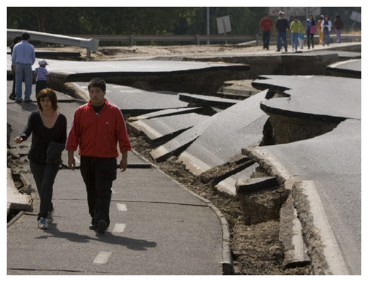
© Ian Salas/epa/CorbisPeople walk by a destroyed road in Santiago, Chile after an earthquake of 8.8 on the Richter scale that hit the country early Feb. 27, 2010.

The magnitude-8.8 earthquake that pummeled Chile in February 2010 did not relieve seismic stress the way scientists thought it might have, a new study suggests.

Quake risk thus remains high in the region, geologist Stefano Lorito of Italy's National Institute of Geophysics and Volcanology in Rome and his colleagues report online Jan. 30 in Nature Geoscience. In places, risk might even be higher than it was before last year's quake.

The geologic stress remains because instead of the ground moving the most where stress had been building the longest, the team reports, the greatest slip occurred where a different quake had already relieved stress just eight decades earlier.

Scientists would like to be able to point at a fault segment that built up stress the longest and say it was primed to go next. But the new work shows that stress buildup does not automatically translate to an earthquake happening right in that area, says geophysicist Ross Stein of the U.S. Geological Survey in Menlo Park, California, who was not involved in the research. "It's a very logical approach," Stein says. "But I don't think it holds up."

Fish

Fish develop red spot fungus after floods

fish,dead,redspot,fungus
© AAP
Fish in Brisbane waterways are starting to develop a red spot fungus from flood contamination, while authorities are rushing to fix a treatment plant to stop a sewage leak.

The Oxley sewerage plant was flood damaged a fortnight ago.

Department of Environment and Resource Management (DERM) director general John Bradley said Oxley Creek's enterococci levels, which indicate sewage contamination, were "250 times higher" than normal.

Bizarro Earth

Tonga - Earthquake Magnitude 6.0

Tonga Quake_310111
© USGSEarthquake Location
Date-Time
Monday, January 31, 2011 at 06:03:26 UTC

Monday, January 31, 2011 at 07:03:26 PM at epicenter

Time of Earthquake in other Time Zones

Location
21.943°S, 175.510°W

Depth
68.6 km (42.6 miles)

Region
TONGA

Distances
95 km (60 miles) SSW of NUKU'ALOFA, Tonga

360 km (225 miles) ESE of Ndoi Island, Fiji

400 km (245 miles) SSW of Neiafu, Tonga

1905 km (1180 miles) NNE of Auckland, New Zealand

Cloud Lightning

Storm could end dry spell in California

A Pacific storm was expected to slam into the West Coast on Sunday, ending a long dry spell in California as it brings rain and snow to the higher elevations.

Winter weather advisories were posted for the western slopes of the Sierra Nevada, where as much as a foot of new snow is expected. Rain could make its way into Southern California late in the day and into Monday.

Farther to the north, snow was expected to fall in Idaho and Montana before creeping into the Dakotas late Sunday. Winter weather advisories were posted for much of the area in anticipation of up to 10 inches of snow and wind gusts as high as 25 mph.

Cloud Lightning

US: Multi-Day Dangerous, Destructive Winter Storm

us,weather map
© National Weather Service

A multi-day, multi-region potentially historic and destructive winter storm will unleash its fury beginning Monday and will last through Wednesday.

When everything is said and done, the storm may very well impact a third of the population of the United States; approximately 100 million people.

Its reach will be felt from the Front Range of the Colorado Rockies to the Ohio Valley to the coast of New England.

Accompanied with the winter storm will be a severe thunderstorm threat across the South capable of producing damaging winds, hail and a few tornadoes.

Our Midwest storm coverage will be categorized into the four factors: heavy snow, destructive ice, tornadoes and bitter cold. To find out more on the various factors, click on each of the images above.


Bizarro Earth

Swarm of nine earthquakes at Mount St. Helens

Mount St. Helens, Washington - A series of nine small earthquakes shook an area near Mount St. Helens over the weekend.

mt.st.helens
© Susan Wyatt/ KING 5 News
Seismologists at the University of Washington have been monitoring the quakes.

A 2.6 quake occurred at 2:26 p.m. on Saturday about six miles north of the volcano. Another quake, a 2.5, occurred at 2:44 p.m. in the same area. The depth for both quakes was two miles. Another quake occurred six miles north-northwest at 10:48 p.m. That measured 2.2 and was 2.2 miles deep.

Smaller quakes, ranging from magnitude 1.3 to 2.2, occurred on Sunday.

Camera

Photo: Eruption of Colima Volcano As Seen From Orbit

Colima Volcano, Mexico's most active, has been erupting since 1998. The eruption began with several months of earthquakes beneath the volcano, followed by explosions and rockfalls at the summit lava dome as it began to grow.

colima volcano
Dome growth was accompanied months later by a series of lava flows which cascaded down the southwestern flank of the mountain, stretching up to 3,100 meters (10,000 feet) from the summit. Since then dome growth has continued, with a few periods of actively flowing lava. As of March 2010, the dome was growing about 2,000 cubic meters (70,000) cubic feet a day, leading to frequent small rockfalls and occasional ash plumes. In January 2011, local newspapers reported "dust plumes" rising over Colima, likely pulverized lava stirred up by landslides at the summit dome.

Bizarro Earth

Hundreds evacuate as Japan volcano erupts

volcano
© AFPMount Shinmoedake has been belching smoke and ash into the air since late Wednesday
Tokyo - Hundreds of people living near a Japanese volcano that has been spewing columns of smoke and ash thousands of metres into the air were forced to evacuate their homes Monday, a local official said.

More than 600 residents of the town of Takaharu in Miyazaki prefecture, on the eastern outskirts of the erupting Mount Shinmoedake, were sheltering in school gyms and community halls, an official said.

Municipal authorities had issued an evacuation advisory for 1,158 residents in high-risk districts near the 1,421-metre (4,689-foot) volcano earlier Monday.

Cloud Lightning

Queensland Braces for Worst Ever Storm - Cyclone Yasi

Image
© Commwealth of Australia 2011Cyclone Yasi's predicted path
The state of Queensland, still reeling from the effects of weeks of widespread flooding, is bracing for the arrival of what could be the state's worst cyclone in history.

Tropical Cyclone Yasi, which currently lies northwest of Vanuatu in the Pacific Ocean, is expected to strengthen into a category four storm, the second highest category, before hitting the north coast of the Sunshine State later this week.

In preparation for its arrival, tourist resorts on the popular Whitsunday Islands have been evacuated and several ports along the busy coast have been shut down. Residents in towns from Innisfail to Mackay have been warned to batten down the hatches or consider fleeing before the storm hits early on Thursday morning, while emergency management teams have held meetings across the state's north.

Authorities have also warned locals to stock up on food, water, batteries and other essentials in case they are cut off for a number of days after Yasi strikes.

There are fears that Yasi could whip up the seas and create a storm surge that would cause significant flooding in low-lying areas, just weeks after devastating floods killed more than 30 people and covered an area the size of France and Germany combined.