Earth ChangesS


Bizarro Earth

4.0 Earthquake Hits Hawaii Island

An earthquake hit Monday morning on the island of Hawaii. The U.S. Geological Survey (USGS) measured the earthquake as 4.0 on the Richter scale, but the Pacific Tsunami Warning Center initially said it was a magnitude 5.2. State Civil Defense reports there was no tsunami threat.

The quake's depth was 6.5 miles, according to the USGS.

The epicenter of the quake was at 20.113°N, 155.175°W approximately 10 miles offshore of Laupahoehoe or about 29 miles NNW of Hilo. It struck at 9:44 am.

Fish

Ocean "Dead Zones" Spreading

The number of "dead zones" in coastal regions around the world continues to rapidly increase, according to a study conducted by researchers from the Virginia Institute of Marine Science and the University of Gothenberg, and published in the journal Science.

Bizarro Earth

5.3 Earthquake Off Guatemala's Coast

The U.S. Geological Survey says an earthquake with a preliminary magnitude of 5.3 has been recorded in the Pacific Ocean just off the coast of Guatemala.

There was no immediate word on whether the earthquake was felt or caused any damage.

The quake was recorded just after midnight (2 a.m. EDT) at a depth of 47 miles and centered 65 miles south of Guatemala City.

Bizarro Earth

California: 2.3 Earthquake Strikes Near Milpitas

The U.S. Geological Survey is reporting an earthquake with a preliminary magnitude of 2.3 struck this morning in Santa Clara County.

According to the USGS, the earthquake struck at about 5:55 a.m. and had a depth of 4.1 miles.

The quake was centered 7 miles east of Milpitas and 10 miles northeast of San Jose City Hall, according to the USGS.

Umbrella

Australia: Cyclone Hamish is heading for South Queensland

Cyclone Hamish 2
© Commonwealth of Australia 2009, Bureau of MeteorologyColour infrared image taken on 9 March 2009
The weather bureau expects Cyclone Hamish will remain a Category 4 system tonight as it continues moving along the central Queensland coast.

The Category 4 storm is located off the Capricornia coast and is estimated to be 255 kilometres east of Yeppoon and 245 kilometres north-north-east of Bundaberg, moving south-east at 17 kilometres per hour.

Magnify

Australia: Crocodile bites snorkeller at Lizard Island

Rangers are searching for a small crocodile that bit a man on the shoulder while he was snorkelling in Queensland's far north.

The Environmental Protection Agency says the man was snorkelling off Lizard Island, north of Cairns, on Sunday afternoon when a crocodile attacked him.

Blackbox

Arctic summer ice could vanish by 2013

The Arctic is warming up so quickly that the region's sea ice cover in summer could vanish as early as 2013, decades earlier than some had predicted, a leading polar expert said on Thursday.

Warwick Vincent, director of the Center for Northern Studies at Laval University in Quebec, said recent data on the ice cover "appear to be tracking the most pessimistic of the models", which call for an ice free summer in 2013.

The year "2013 is starting to look as though it is a lot more reasonable as a prediction. But each year we've been wrong -- each year we're finding that it's a little bit faster than expected," he told Reuters.

Cloud Lightning

US: Storms throw bus into Indiana building, damage homes

Strong winds from severe thunderstorms raked parts of the Midwest on Sunday, tossing a school bus onto a building, destroying or damaging homes, and cutting off power to thousands of customers in Indiana and Illinois.

Emergency management agencies reported a tornado in Lawrence County, said John Erickson, a spokesman for the Indiana Department of Homeland Security. The National Weather Service has not confirmed the reports.

Footage from WTHR-TV in Indianapolis showed a school bus lying atop a flattened building in Fayetteville, about 70 miles south of Indianapolis, where the tornado was reported.

Lawrence County Sheriff Sam Craig said at least 19 houses had been damaged, including three that were leveled.

Bizarro Earth

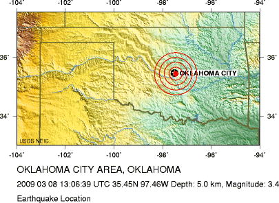
US: Earthquake Magnitude 3.4 in Oklahoma City

Image
© US Geological Survey

Sunday, March 08, 2009 at 13:06:39 UTC

Sunday, March 08, 2009 at 08:06:39 AM at epicenter

Location 35.447°N, 97.457°W

Depth 5 km (3.1 miles) set by location program

Distances:
* 1 km (0 miles) S (174°) from Smith Village, OK

* 1 km (1 miles) WNW (287°) from Del City, OK

* 5 km (3 miles) NNE (26°) from Valley Brook, OK

* 8 km (5 miles) ESE (119°) from Oklahoma City, OK

* 301 km (187 miles) NNW (348°) from Dallas, TX

Compass

Don't e-mail me the UKMET ideas

I have been getting a lot of e-mail on the UKMET center announcement which people email me, and I am not reading. Why? Because such agenda-driven agencies, and plainly they are, can distract me from the actual weather. I am aware of their position, I think it makes them helpless in the face of the obvious if its coming, and unlike me, I do respect the opposite side's argument. What I don't respect is a scientific agency that is driven more by government policy than the science. So, their agenda is plain.. Mine is also..,debate and let's get the right answer.

Succinctly put, I can't trust what they say given the things I know to be fact about past climate conditions that the Earth has experienced. They have ranged from ice fairs on the Thames in the time of Victoria to weather which inspired the tapestry's of orange trees around the time of the Tudors...which occurred at the last end of the warm cycle that predated the mini ice age that was ending around the time of the Victorian reign.