Earth ChangesS


Stop

US: Snowstorm wreaks havoc, barrels east; Metrodome roof collapses

A powerful snowstorm barreled east through the Midwest on Sunday, bringing with it more precipitation and gusty winds and leaving behind a trail of significant damage, large snow drifts and subarctic temperatures, according to the National Weather Service.


Winter storm warnings and advisories Sunday extended as far west as Illinois, as far east as Pennsylvania, and as far south as northern Alabama and Georgia.

Meanwhile, residents of the upper Midwest who braved at-times blizzard conditions on Saturday faced the prospect Sunday night of wind chills dipping, in spots, as low as 30 degrees below zero. This comes after up to 23 inches of snow fell in parts of Minnesota and as many as 18.5 inches in Wisconsin since Friday.

"We could see wind chills (that are) obviously extremely dangerous for people, to have that kind of exposure for any length of time," said Tod Pritchard, a spokesman for the Wisconsin Emergency Management agency.

Cloud Lightning

Storms bring flood threat to Washington, Oregon rivers

Storm system
© Associated Press
Record rainfall in the Pacific Northwest triggered mudslides and threatened to cause severe flooding of some Western Washington rivers Sunday.

Although the rain had eased in much of southwest Washington and northwest Oregon, including Portland, downpours continued from Seattle north, swelling rivers and threatening some small towns. The rain was expected to lessen Sunday evening, with the worst of the flood danger over by early Monday.

Still, flood watches or warnings remained in effect for the region, and forecasters said storms could dump 6 inches or more of rain in the Cascade Range and Olympic Mountains.

"We're looking at the wettest storm system we've had for in almost two years," said National Weather Service meteorologist Kirby Cook in Seattle.

Better Earth

Stillaguamish River Reaches Record Flood Stage

Image
© Jim FormanThe Stillaguamish River at Arlington
Record rainfall has flooded roads and triggered mudslides in Western Washington. King County road closures.

"Many areas around the region picked up anywhere from 3/4" of rain at Whidbey Island to 5.68" at Bremerton on Sunday!" said KING 5 Meteorologist Jim Guy. "Since midnight, SeaTac has recorded 2.20". That's a new daily maximum record."

The Stillaquamish River reached record flood stage Sunday afternoon, tying the record set in November of 2006. About 230 homes and businesses in Granite Falls near the Stillaguamish River have been asked to evacuate.

Severe and possibly near-record flooding is also predicted in on the Snohomish River near Monroe and the city of Snohomish. Weather forecasters say deep and swift flood waters will inundate many roads, including Highway 530 east of Arlington and most valley roads downstream of Interstate 5 to Stanwood.

Bad Guys

Wik-Bee Leaks: EPA Document Shows It Knowingly Allowed Pesticide That Kills Honey Bees

Bee Die Off
© Fastcompany

The world honey bee population has plunged in recent years, worrying beekeepers and farmers who know how critical bee pollination is for many crops. A number of theories have popped up as to why the North American honey bee population has declined--electromagnetic radiation, malnutrition, and climate change have all been pinpointed. Now a leaked EPA document reveals that the agency allowed the widespread use of a bee-toxic pesticide, despite warnings from EPA scientists.

The document, which was leaked to a Colorado beekeeper, shows that the EPA has ignored warnings about the use of clothianidin, a pesticide produced by Bayer that mainly is used to pre-treat corn seeds. The pesticide scooped up $262 million in sales in 2009 by farmers, who also use the substance on canola, soy, sugar beets, sunflowers, and wheat, according to Grist.

The leaked document (PDF) was put out in response to Bayer's request to approve use of the pesticide on cotton and mustard. The document invalidates a prior Bayer study that justified the registration of clothianidin on the basis of its safety to honeybees:

Bizarro Earth

Papua New Guinea - Earthquake Magnitude 6.2 - Bougainville Region

PNG Quake_131210
© USGSEarthquake Location
Date-Time:
Monday, December 13, 2010 at 01:14:43 UTC

Monday, December 13, 2010 at 11:14:43 AM at epicenter

Time of Earthquake in other Time Zones

Location:
6.563°S, 155.658°E

Depth:
144.8 km (90.0 miles)

Region:
BOUGAINVILLE REGION, PAPUA NEW GUINEA

Distances:
40 km (25 miles) SSE of Arawa, Bougainville, PNG

100 km (65 miles) W of Chirovanga, Choiseul, Solomon Islands

990 km (610 miles) ENE of PORT MORESBY, Papua New Guinea

2325 km (1450 miles) N of BRISBANE, Queensland, Australia

Igloo

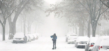
US: Storm Socks Midwest, Cancels Flights, Closes Roads

Winter Storm
© AP Photo/Craig Lassig
Chicago - A powerful, gusty storm dumped mounds of snow across the upper Midwest on Sunday, closing major highways in several states, canceling more than 1,600 flights in Chicago and collapsing the roof of the Minnesota Vikings' stadium.

At least two weather-related deaths were reported as the storm system dropped nearly 2 feet of snow in parts of Minnesota and marched east. A blizzard warning was in effect Sunday for parts of eastern Iowa, southeastern Wisconsin, northwestern Illinois and northern Michigan, according to the National Weather Service. Surrounding areas, including Chicago, were under winter storm warnings. Much of Iowa was under a wind-chill advisory.

In Minneapolis, the heavy snow left the Metrodome decidedly unready for some football. Video inside the stadium aired by Fox Sports showed the inflatable Teflon roof sagging before it tore open, dumping massive amounts of snow across one end of the playing field.

No one was hurt but the Vikings' game against the New York Giants had to be moved to Detroit's Ford Field. The day of the game had already been pushed back from Sunday to Monday because the storm kept the Giants from reaching Minneapolis on time. Stadium officials were trying to repair the roof in time for the Vikings' next home game, Dec. 20 against Chicago.

Igloo

The £43 million summit that is polluting the planet: Cancun will generate 25,000 tons of CO2

Image
© AlamySoaring fumes: Flying delegates to the summit will produce considerable greenhouse gas. But should we expect anything less from these parasites?
The climate change summit in Cancun will generate 25,000 tons of carbon dioxide, its Mexican hosts admitted last night.

That means the £43 million event will produce as much greenhouse gas as an average-sized African country would over the same two-week period.

The figure includes the carbon generated by flights, transport, hotels and food - and means the conference is polluting at the same rate as Somalia or Mali.

The organisers of the UN talks say they will plant trees and pay farmers to protect forests to offset the emissions. The Mexicans are also recycling rubbish from the conference, which spans two venues connected by shuttle buses running on biodiesel.

However, the rubbish has to be driven 800 miles to the nearest recycling plant in Mexico City.

Last year's summit in Copenhagen generated an estimated 5,000 tons of carbon dioxide - a figure that was lower because many delegates did not need to fly.

Igloo

"Gore Effect" on Steroids: Six straight days of record low temperatures during COP16 in Cancun Mexico - more coming

The irony, it burns. Do you think maybe Gaia is trying to send the U.N. and the delegates a message? One record low was funny, three in a row was hilarious, a new record low for the month of December was ROFL, but now six straight days of record lows during the U.N. COP16 Global Warming conference? That's galactically inconvenient. The whole month so far has averaged below normal:

[Click on images to enlarge]

Image
© Unknown

Igloo

Ice Age Alert! Central England has coldest introduction to winter since 1659!

Image
© Press Association
"The central England Temperature (CET) from the 1st-7th of December is -1.9, making this the coldest opening week of December since 1879," says meteorologist Joe Bastrardi.

With 1879 being the coldest opening week on CET record, this week has been the second coldest opening week to December since CET records began in 1659.

Those records are for a one-week period.

When you look at the two-week period, says Bastardi, the last week of November and the first week of December, it's the coldest since CET records began in 1659.

This puts central England back to the temperatures of the Little Ice Age.

And there's more to come, Bastardi warns.

"Preparation for renewal of extreme cold from France to Scandinavia and west through the UK should be made."

See entire article

Igloo

Signs that show Man Made Global Warming is Definitely Still Happening

Image
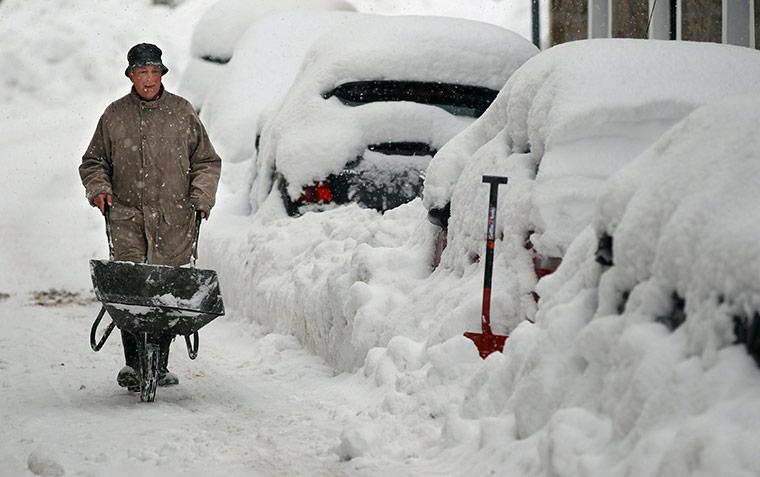
© Jeff J Mitchell/Getty ImagesA man attempts to clear snow around cars in Dunning, Scotland, in late November 2010
As your boiler breaks down, your pipes freeze, your car won't start, your Ocado delivery fails to arrive, your train is cancelled, your neck is broken after slipping on black ice and you lie in an emergency ward waiting for a doctor to turn up only to learn that they're all off today because of the weather, you might be forgiven for thinking that all this has something to do with global cooling, changes in the Pacific Decadal Oscillation, and the decline in sunspot activity perhaps auguring a new Maunder minimum.

But you couldn't be more wrong.

"It's all actually a sign that man made global warming is very much a live issue and that there's more of it happening than ever," says a top scientist, who holds the British record for securing grant-funding for global warming research projects so he must know what he's talking about.