Earth ChangesS


Bizarro Earth

South Island of New Zealand - Earthquake Magnitude 6.0

NZ Quake_130611
© USGSEarthquake Location
Date-Time:
Monday, June 13, 2011 at 02:20:50 UTC

Monday, June 13, 2011 at 02:20:50 PM at epicenter

Time of Earthquake in other Time Zones

Location:
43.580°S, 172.740°E

Depth:
9 km (5.6 miles)

Region:
SOUTH ISLAND OF NEW ZEALAND

Distances:
13 km (8 miles) NNE of Christchurch, New Zealand

207 km (128 miles) SSE of Westport, New Zealand

292 km (181 miles) SW of WELLINGTON, New Zealand

323 km (200 miles) NNE of Dunedin, New Zealand

Phoenix

US: Wallow Fire Now Likely to Become Arizona's Biggest

Image
© Jill Torrance / Arizona Daily StarShelly Billingsley, center, receives some comforting words from Shelly Myrick, both of Springerville, in the evacuation center at Blue Ridge High School in Pinetop. At left, Lucille Ashcroft partakes of a meal prepared by volunteers.
Authorities say a raging wildfire that could become the largest in Arizona history is now 5 percent contained after charring more than 386,000 acres and destroying 22 homes in Greer.

The Wallow Fire has burned more than 525 square miles in Eastern Arizona. But fire officials Thursday evening said they were optimistic some residents who have been forced to flee the flames would be allowed back home by the weekend.

Full evacuations were still in place for Eagar, Springerville, Sunrise, Greer, Blue River, Alpine, Nutrioso and many subdivisions. More than 5,000 residences are threatened by the massive fire, officials said.

Fire officials reported earlier Thursday that six homes were burned overnight in Greer. But crews finished touring the area and assessing the damage by late afternoon and said 22 homes in Greer were destroyed and five other homes were damaged.

Officials also say 24 outbuildings in Greer were destroyed along with one vehicle.

A total of 29 residences have been destroyed so far.

Bizarro Earth

Eritrea/Ethiopia Region: Earthquake Magnitude 5.1 and 9 subsequent large aftershocks

Image
© USGS
Date-Time:
Sunday, June 12, 2011 at 15:37:05 UTC
Sunday, June 12, 2011 at 06:37:05 PM at epicenter

Time of Earthquake in other Time Zones

Location:
13.458°N, 41.684°E

Depth:
10 km (6.2 miles) set by location program

Region:
ERITREA - ETHIOPIA REGION

Distances:
128 km (79 miles) WNW of Assab, Eritrea
193 km (119 miles) SW of Al Hudaydah, Yemen
239 km (148 miles) E of Mekele, Ethiopia
357 km (221 miles) ESE of ASMARA, Eritrea

Phoenix

Wildfires more rampant in Russia in 2011, spread over east

Image
© Valery GacheevWildfires more rampant in Russia in 2011, spread over east
Russia reported 186 wildfires burning in forests and peat bogs on Sunday, covering an area more than three times the size of that for the same period last year.

"Overall, more than 12,100 wildfires have emerged in Russia since the beginning of the fire-hazardous season of 2011 on a total area of about 752,500 hectares as compared with 228,400 hectares last year," the Emergencies Ministry said.

Bizarro Earth

Solomon Islands - Dead Fish Found Floating in Lagoon

Dead Fishes
© Solomon Star

People of central Marovo lagoon in the West have baffled over the sightings of dead fish floating in the lagoon since the weekend.

Reports reaching Solomon Star early this week said since Saturday there were schools of dead fish found floating inside the lagoon area.

A man from the area Lloyd Nonga said the sightings of the dead fish have caused panic amongst the villagers.

"Dead fish found here in Marovo lagoon for the last 3 days, since Saturday.

"There were dead fish floating in the sea which caused panic among local communities here in the central part of Marovo lagoon," he said.

Mr Nonga who informed this paper via email said the exact cause that led to the death of fish stock in the area is still unknown as of yesterday.

But he said locals have blamed a foreigner who is developing a tourism resort in the area.

"Locals are pointing figure to a foreigner who is married to a local Marovo woman and is developing an island on the edge of the lagoon for tourism," he said.

Camera

US: Landsat satellite images compare before and after Massachusetts tornado

Satellites provide a lot of useful information and the Landsat 5 satellite captured an image of the long damage track created on June 1, 2011 when a tornado tracked from Springfield to Sturbridge, Mass. An earlier image is now available from 2010 that enables people to more clearly see the damage path the June 2011 twister created on its eastward track.

A Landsat 5 satellite image from October 8, 2010 has been released from NASA and the U.S. Geological Survey that shows the area between Springfield and Sturbridge, Mass. where the tornado touched down.

Image
© NASA/USGS, Mike TaylorLandsat image Before Tornado on Oct. 8, 2010. This is a Landsat 5 satellite image of the area between Springfield and Sturbridge, Mass. taken on October 8, 2010, where the tornado made a track on June 1, 2011.
Emergency managers and land managers have contacted NASA and have been using Landsat imagery to determine the tornado's damage path, and help assess what areas have been affected.

Arrow Up

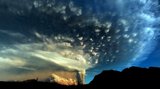
Australian, New Zealand flights disrupted by Chilean volcanic eruption

Image
© UnknownA thick plume of ash from the erupting Puyehue volcano in the Andes shifted direction into Chile on Sunday after spewing volcanic dust over parts of Argentina.
Sydney - Ash from Chile's volcanic eruptions prompted Australian airline Qantas to ground some domestic services and some flights to New Zealand on Sunday, after plumes drifted across the Pacific.

Strong winds have carried the ash clouds 9 400km across the Pacific to New Zealand since Chile's Puyehue volcano erupted more than a week ago, and they are now moving towards Australia.

Qantas cancelled all flights in and out of the southeastern island of Tasmania and services from Sydney and Melbourne to and from Christchurch, Queenstown and Wellington in neighbouring New Zealand, disrupting about 1 500 passengers.

An earlier flight to Auckland had gone ahead, Qantas said, but services to this city were also at risk of being suspended. The airline was expected to make another announcement later on Sunday.

Phoenix

Video: Chilean volcanic eruption DWARFS Eyjafjallajökull 2010 eruption

Puyehue volcano continued to erupt on Monday, billowing smoke and ash high into the sky. The volcano in the Caulle Cordon mountain range began erupting violently on Saturday afternoon. Lightning in the rising cloud provided a dazzling display. The eruption has forced more than 3,500 people living nearby to evacuate, but there are no reports of any injuries.


Snowman

It's SNOWING in Wales - but Britain is officially in a drought

Image
Snow fell on Snowdon June 11, 2011 while, right, Wales near drought status
Large parts of Wales may be battling near drought conditions but at the top of the nation's tallest mountain it was snowing.

Visitors to Snowdon were baffled yesterday when they arrived at the top of the 1,085m-tall mountain to find that there was snow blowing around for an hour.

Across Wales, farmers, gardeners and anglers are facing one of their most difficult summers in the last two decades because of the lack of rain.

Despite recent rainfall, Wales has been declared to be in near-drought status while parts of England, including key arable farming areas in East Anglia, are facing water restrictions because of the drought.

At the top of Snowdon yesterday, visitor Mary Pearce, 62, of Roath, Cardiff, said: "It is bizarre - it is the middle of June, days before the start of Wimbledon and just over a week before the summer solstice."

Cloud Lightning

Heavy rain, melting snow cause devastating floods across Norway, washing away houses, roads

Image
© EPADevastating flooding has hit Norway.
Torrential rains combined with melting snow have caused devastating floods across central Norway, washing away several houses and roads and causing landslides.

One person has been injured in the floods, but it was unclear Saturday whether their condition was serious.

Spokesman Morten Harangen at the Directorate for Civil Protection and Emergency Planning says the northern part of the country has also been affected, but is more due to high temperatures that have sped up the snow-melting in the mountains.

Harangen says between 100-200 people have been evacuated so far.

Late Friday, Norway's Justice and Transport Minister Knut Storberget met with rescue work representatives to discuss the flood situation.