Earth ChangesS


Cloud Grey

Another amazing Roll Cloud stretching across Texas sky

A roll cloud stretched across the morning sky in Timbercreek Canyon, Texas, on Monday, Nov. 4, 2013. Todd Mask captured it on video, describing the cloud as "rolling like an ocean wave" and "like a horiztonal vortex."

Roll clouds form along sea breezes, cold fronts and thunderstorms. "Sinking cold air causes warm, moist air on the planet's surface to climb to higher altitudes, where the moisture condenses into cloud form," explains LiveScience. "Winds from the storm "roll" the cloud parallel to the horizon." In this case, winds from an east-moving storm system created the distinct tube shape.

For more info on different types of cool clouds, check out the SKYE Guide to Extraordinary Clouds.


Bizarro Earth

New explosions detected at Russian volcano on snowy Kamchatka Penninsula

Kamchatka Zhupanovksy volcano
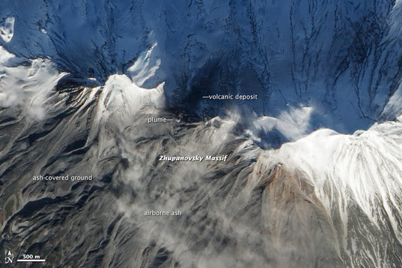
© NASA Earth Observatory/Image by Jesse Allen and Robert SimmonOn Nov. 5, a NASA satellite spotted ash above Kamchatka's Zhupanovksy volcano.
A remote Russian volcano may be readying for a new eruption, according to NASA's Earth Observatory. On Nov. 5, NASA's Earth-Observing 1 satellite spotted ash above the 9,702-foot-tall (2,958 meters) Zhupanovksy volcano, which recently woke from a decades-long slumber. The snowy peaks also shows signs of phreatic explosions - the stupendous blasts that result from hot lava meeting snow, ice or water, the Earth Observatory reported.

Zhupanovksy's latest activity started on Oct. 23, when the volcano spewed ash 16,400 feet (5 kilometers) into the sky. It was the first explosive eruption at the volcano since 1959, according to KVERT, the Kamchatka Institute of Volcanology and Seismology, which monitors volcanic and earthquake hazards in the Russian peninsula. The initial blast of ash and volcanic gases was followed by several days of phreatic bursts and strong gas emissions from fumaroles (gas vents) at the peak, KVERT reported.

Comment: The pace of volcanic activity is ramping up around the world. Just a small sample of recent activity:

Reclus Volcano in Chile Appears to be Reawakening as Earthquakes Felt in Nearby Towns
Strong activity continues at Indonesia's Mount Lokon volcano
Alaska's Mt. Pavlof volcano is 'very, very hot'
Iceland's Hekla volcano: strong inflation suggests volcano could be close to erupting


Bizarro Earth

USGS: Earthquake Magnitude 6.1 - Scotia Sea

Scotia Sea Quake_131113
© USGS
Event Time
2013-11-13 23:45:48 UTC
2013-11-13 20:45:48 UTC-03:00 at epicenter

Location
60.261°S 47.196°W depth=10.0km (6.2mi)

Nearby Cities
924km (574mi) SW of Grytviken, South Georgia and the South Sandwich Islands
1394km (866mi) SE of Ushuaia, Argentina
1641km (1020mi) SE of Punta Arenas, Chile
1666km (1035mi) SE of Rio Gallegos, Argentina
1159km (720mi) SSE of Stanley, Falkland Islands

Technical Details

Music

Strange sounds in Saskatoon: More unexplained noises caught on video


It resembles the sound of the mothership in Close Encounters of the Third Kind, or the snarl of a long-dead dinosaur crawling back out of the Earth's crust, or simply the wailing of the coming apocalypse.

Whatever it was - even if completely benign - the thundering sounds over Saskatoon recently were alarming enough, and loud enough, to stir Ernie Werezak awake and compel him to grab his camera and start recording.

According to Werezak, who posted the footage on YouTube, he was jolted out of bed by the sounds, which he says seem to be 'in the air,' around 5 a.m. last Saturday.

YouTube user GTIkitty commented on the video and confirmed also hearing the sounds.

Nuke

Fukushima and catastrophic climate change: The Earth community in hospice

Earth in hand, blowing away
© unknown
To be in a body is to hear the heartbeat of death at every moment.

~Andrew Harvey~

As I write these words in early November, 2013, humanity is confronting an unprecedented and horrific challenge which it may or may not survive. I'm referring to two uncanny realities about which we are not being told the unmitigated truth.

The Fukushima Daiichi nuclear power plant which suffered a catastrophic meltdown on March 11, 2011 is poised to inflict death and disastrous illness on millions, if not billions of people, as a result of ghastly amounts of contaminated water that is gushing daily into the Pacific Ocean and has already been detected on the West coasts of Canada and the United States. (28 Signs That The West Coast Is Being Fried By Fukushima Radiation)

Ice Cube

Iceberg the size of Singapore could threaten shipping lanes as researchers race to track it

An iceberg the size of Singapore is drifting away from Antarctica and may enter shipping lanes as researchers race to track its progress.

Image
© ReutersThe Pine Island Glacier ice shelf in Antarctica
An iceberg which is estimated to be around the size of Manhattan or Singapore could threaten shipping if it drifts into busy international lanes.

UK researchers have now been given an emergency grant to track the iceberg which is approximately 270 square miles in size.

The giant block of ice broke away from the Pine Island Glacier in July but it was iced-in due to the freezing winter temperatures in Antarctica.

While the iceberg could move eastwards along the Antarctic coast, it could also drift into the South Atlantic Ocean where it could potentially pose a hazard to ships if it crosses into international shipping lanes

Now the £50,000 research grant will fund a six month project which will predict the movements of the iceberg through the Southern Ocean.

Cloud Precipitation

Haiyan of the Atlantic: Is this possible?

 Hurricane
© Unknown
There have already been storms like Super Typhoon Haiyan in the Atlantic, although the jury could be out for months on the actual power of Haiyan.

"If there were instruments in its path, they didn't live through it," said Brian McNoldy, a storm researcher at the University of Miami's Rosenstiel School of Marine and Atmospheric Science. "We don't know exactly how strong the storm was, but it appears to be slightly stronger and slightly larger than Hurricane Andrew."

That would place it among the world's most powerful tropical cyclones, as only Camille (1969), Katrina (2005) and an unnamed storm that hit the Florida Keys in 1935 are known to have been more powerful than Andrew (1992), according statistics from the National Hurricane Center.

Better Earth

Expect increasingly violent cyclones, weather experts warn

Image
© AFP Photo
Meteorologists have yet to formally link global warming to typhoons like the one that devastated the Philippines, but they expect increasingly extreme weather phenomena due to a rise in ocean temperatures.

The trail of death and destruction left in the wake of Super Typhoon Haiyan was at the forefront of a new round of United Nations climate talks that opened Monday in Poland, as Philippine authorities warned some 10,000 people may have died.

Haiyan - the most powerful typhoon to make landfall ever recorded - swept over the Philippines Friday, just days before the 12-day UN climate talks opened in Warsaw to a slew of warnings about potentially disastrous warming with increasingly extreme weather phenomena.

"There is a tendency of (oceans) warming up and an increase in the intensity of cyclones is part of the risks," said Herve Le Treut, a Paris university professor and climatologist.

Typhoons, hurricanes and cyclones are different names given to the same powerful weather phenomenon according to the region it hits, but meteorologists use the generic term "cyclone" when talking generally about these super storms.
Windsock

Freak 'Tornado' rips through North Cornwall

Image
© Unknown.The poly-tunnel at Trevone Farm was flattened by the whirlwind.


A freak whirlwind caused thousands of pounds' worth of damage to property after ripping through three North Cornwall coastal villages early on Saturday morning.

Outbuildings were destroyed in Trevone, and roofs of houses were damaged in Harlyn Bay and Constantine Bay after what residents described as a "tornado'' struck the area.

A terrified couple out walking their dog at 7.30am on Saturday in Trevone ran to take shelter in a ditch as debris flew towards them.

Another resident of the village found her chicken shed had been upended and landed on a road, killing one of her chickens.

Cloud Lightning

NOAA images show wind farms distort weather radar data, affecting their primary mission of forecasting and safety

"Chaotic wind velocities associated with the rotating turbine blades triggers the doppler radar mesocyclone detection algorithm"

Note: this essay was written by the National Weather Service Forecast Office in Burlington, Vermont and tipped to me by a reader. Vermont's wind farm acreage pales in comparison to places like the Texas and Oklahoma, where there are literally thousands of acres of wind farms right in the middle of tornado alley. I've been there and seen them firsthand.
wind farm doppler
Certified Consulting Meteorologist Mike Smith writes:

"While driving to Norman, OK recently I saw the newest "wind farm" to the west of Interstate 35 southwest of Tonkawa. Wind farms show up as bright ground clutter on weather radars and here it is."
One has to wonder just how much trouble wind farms are causing the nation's doppler radar warning system. It looks like a classic case of the law of unintended consequences at work. - Anthony


National Weather Service WSR-88D Radar and Wind Farm Impacts


Introduction

The most valuable tool used by the National Weather Service (NWS) to detect precipitation is the radar. Radar stands for Radio, Detection, and Ranging, and has been used to detect precipitation since the 1940′s, with most of the technology coming from the military.