Earth ChangesS

Cloud Lightning

US: Flooding, Heavy Rain Delays Planting for Hundreds of Thousands of Acres

Image
© Montana News
For years, Gordon Stoner's rule for keeping the rain-soaked Northeast Montana soil from swallowing his tractor was to "turn when the ducks fly," meaning nothing short of a pond would cause him to turn the wheel.

Then the record rains of 2011 turned his fields to soup and kept his tractor in the barn for all but 41 hours over a three-week stretch in May. When he finally got into the field, his tractor's heavy wheels flattened the fooded groundhog tunnels below. Water shot like geysers from the prairie dog holes.

"I have never entertained the thought of not getting a crop in," Stoner said. "You eat an elephant one bite at a time. You just gnaw away at it, but we've got rain in the forecast and if we get much more, I don't know."

It takes a lot to get a Montana farmer to curse the rain, but some are beginning to. Hundreds of thousands of acres have gone unplanted due to unprecedented rains and the number of growing days needed to produce a crop is quickly dwindling. In addition, federal officials now estimate 1.4 million Montana acres-an area slightly larger than Glacier National Park-has been hit by flooding.

Cloud Lightning

US: The Last 'Big One': Remembering the Flood of '52

Image
© TRIBUNE filesFlooded south Bismarck in April of 1952.
The 2011 Missouri River flood certainly will go down as "the big one" in many respects. But major flood events on the river in Bismarck and Mandan are not unprecedented

In 2009, an ice jam in the river caused water to back up. In 1952, a similar scenario played out, hitting the cities hard and fast with no warning.

There was no Garrison Dam in 1952. The only dam on the Missouri River system then was the Fort Peck Dam in Montana but downstream, the Milk River and other tributaries had no dams to hold back the water.

The 1952 flood hit Bismarck and Mandan on April 6, a Sunday morning when many people had yet to return home from church services.

Jim Davis, head of reference of the state archives at the State Historical Society of North Dakota, compiled some data from Bismarck Tribune files and other sources on that flood.

The latest projection for the Missouri River is to crest somewhere between 19 and 19.6 feet.

In 1952, the river hit 27.8 feet. Similar to 2009, an ice jam caused that flood, leaving the water with nowhere to go except into neighborhoods on both sides of the river.

Bizarro Earth

Eritrean volcanic ash cloud heading toward Israel

volcanic ash cloud
© AP
A volcanic ash cloud created after a volcano erupted in the northern African country of Eritrea is heading toward Israel, the Israel Meteorological Service confirmed on Tuesday.

It is not yet certain whether the cloud will disrupt flights in the area.

According to current estimations, the ash cloud is moving high in the atmosphere, and will probably remain too high to cause any travel disruptions or changes in the quality of air.

Attention

US: Windsor, Pennsylvania, Tornadoes did hit on Sunday

windsor PA tornado
After spending the weekend in Wildwood Crest, New Jersey, Kris and Luanne McNew returned to their Windsor Township home Sunday night to downed trees and power lines along their wooded property.

More than three decades ago, they opted to build their two-story home in the 600 block of Bahns Mill Road, which is surrounded by woods, said Luanne McNew.

And during all their years spent in the home, a tree never fell onto their home or property, said McNew.

That changed Sunday, after a tornado touched down in Windsor Township.

Sun

Sun's Fading Spots Signal Big Drop in Solar Activity

Sun Spot
© The Royal Swedish Academy of Sciences, V.M.J. Henriques (sunspot), NASA Apollo 17 (Earth)A photo of a sunspot taken in May 2010, with Earth shown to scale. The image has been colorized for aesthetic reasons. This image with 0.1 arcsecond resolution from the Swedish 1-m Solar Telescope represents the limit of what is currently possible in terms of spatial resolution.

Some unusual solar readings, including fading sunspots and weakening magnetic activity near the poles, could be indications that our sun is preparing to be less active in the coming years.

The results of three separate studies seem to show that even as the current sunspot cycle swells toward the solar maximum, the sun could be heading into a more-dormant period, with activity during the next 11-year sunspot cycle greatly reduced or even eliminated.

The results of the new studies were announced today (June 14) at the annual meeting of the solar physics division of the American Astronomical Society, which is being held this week at New Mexico State University in Las Cruces.

The studies looked at a missing jet stream in the solar interior, fading sunspots on the sun's visible surface, and changes in the corona and near the poles.

"This is highly unusual and unexpected," said Frank Hill, associate director of the National Solar Observatory's Solar Synoptic Network. "But the fact that three completely different views of the sun point in the same direction is a powerful indicator that the sunspot cycle may be going into hibernation."

Attention

US: New Hidden Quake Fault Found in California

New Fault Line
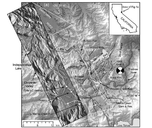
© BSSA/USGS/USACERegional map showing location of the Polaris fault and selected regional faults from the U.S. Geological Survey (USGS). The inset topographic map shows high-resolution airborne LiDAR imagery, with the Polaris fault shown as a bold white line.

You'd think in a seismically active area like California that every potentially earthquake-producing fault to be found would've been identified. It turns out there are plenty of such faults hiding in the ground, and one of them has just been found.

And this fault holds the potential of producing more than just an earthquake - it could also release a flood from a nearby dam.

Scientists with the U.S. Army Corps of Engineers were inspecting the Martis Creek Dam, which sits just outside Truckee, Calif., and about 35 miles upstream from Reno. It is one of 10 dams in the United States that has "urgent and compelling" safety concerns, according to the Corps, which owns the dam. Data from the most recent evaluation revealed that, not only does the dam have significant leakage, it also lies in close proximity to not two, but three fault zones.

The newly discovered, active, 22-mile-long strike-slip fault is named Polaris for the old mining town it runs through (by contrast, the San Andreas Fault is more than 800 miles long).

The Polaris Fault was discovered using laser imaging technology known as LiDAR, which was used as part of the U.S. Army Corps of Engineers' evaluation of the dam. LiDAR emits laser pulses down toward the ground from an airplane - even through dense vegetation - to get high-resolution topology maps. Once researchers stripped off the heavy pine tree layer from the maps, they found evidence of the fault sitting just 200 meters from the dam.

"We weren't expecting it at all," said Lewis Hunter, a senior geologist for the U.S. Army Corps of Engineers Sacramento District.

Better Earth

US: Race to raise town's flood wall after levee breaches

Secondary levee is being raised by 3 feet as Missouri River waters approach
Image
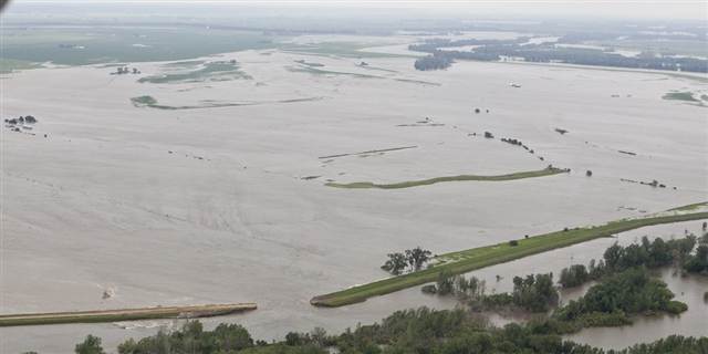
© Nati Harnik/APThe breached Missouri River levee near Hamburg, Iowa, is seen at bottom letting water into farmland on Monday.
Hamburg, Iowa - Crews are trying to beat floodwaters expected to arrive in this Missouri River town on Tuesday by building up a secondary barrier to protect it from a massive hole in the main levee.

The river ruptured two levees in northwest Missouri on Monday, sending torrents of water over rural farmland toward Hamburg in southwest Iowa and a Missouri resort community downriver.

By Wednesday, water spilling through a nearly 300-foot hole in the levee near Hamburg, population 1,100, was expected to top a secondary levee started last week to protect the town.

The Army Corps of Engineers said crews are working to increase that wall's height by 3 feet. If it breaks, parts of Hamburg could be under as much as 10 feet of standing water, officials said.

"For right now, we believe we'll be able to get that elevation raised in the time available as that water flows across in the next 48 hours," Col. Bob Ruch, the corps' Omaha District commander, said Monday evening. "We've had excellent working conditions."

Stop

North Dakota, US: Sinkhole closes Fargo overpass

Image
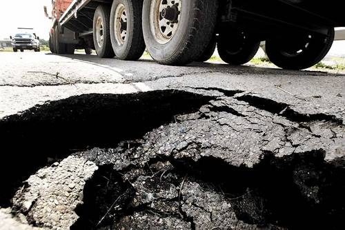
© Dave Wallis / The ForumThe Seventh Avenue North bridge over Interstate 29 in Fargo was closed to traffic after the asphalt road surface caved in because of a sinkhole that opened up Sunday
A bridge over Interstate 29 in north Fargo, slated to be replaced next year, is still sound after a sinkhole was discovered this past weekend near its base, officials say.

Traffic is being detoured away from the Seventh Avenue North overpass because of the sinkhole, which measures about 2 feet deep and 3 feet wide, said Lee Anderson, Fargo Public Works maintenance supervisor.

Jamie Olson with the North Dakota Department of Transportation said Monday that engineers found the sinkhole caused no problems for the 45-year-old bridge.

"There are no issues with the structure of the bridge," Olson said.

NDDOT plans to fully reconstruct the two-lane overpass in 2012, widening it to include an enclosed pedestrian walkway.

Cloud Lightning

US: Is Extreme Weather The New Normal? New England, Nation Experience Destructive Extremes

Image
© Unknown
Click here to watch the video.

Last week temperatures in Boston neared 100 degrees in early June.

Just days before, three Massachusetts residents were killed by a deadly string of three powerful tornadoes that tore across the western part of the state, inflicting tens of millions of dollars in property damage in more than a dozen Massachusetts communities, including Springfield, Monson, Sturbridge and Brimfield.

It will be months before many families can recover.

"We are experiencing most extreme spring on record," said Dr. Jeff Masters, a meteorologist with Weather Underground.

It's not just an issue for New Englanders, although for us it comes on the heels of a brutally cold and snowy winter.

Phoenix

US: Firefighters Secure Homes as Brush Fire Grows

Image
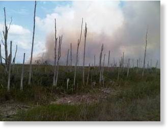
© Tiffanni Helberg/CBS-4 A raging western Miami-Dade brush fire can be viewed from Okeechobee Road. By Saturday the raging flames had destroyed at least 58,000 acres
West Miami-Dade brush fire consumes over 50,000 acres

The brush fire battle in West Miami-Dade isn't getting any easier for firefighters as it continues to burn Friday morning.

The fire has now consumed more than 50,000 acres and is about 55 percent contained, according to the Florida Division of Forestry.

On Thursday, firefighters evacuated homes in the Miccosukee Tiger Trail complex after the fire came as close as 40 feet to the homes. Miami Dade Fire Rescue along with The Florida Division of Forestry teamed up to knock down the flames

"We knew that we couldn't stop it," said Scott Peterich with the Division of Forestry. "So, Miami Dade Fire Rescue and us decided to go ahead and do this counter fire. We created a back fire, and now we have a black area making it safe for the structures."