Earth ChangesS


Bizarro Earth

Philippines: Elusive beaked whale stranded in Subic

Beaked Whale
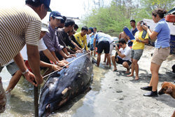
© Henry EmpeñoEarth Day visitor - Marine biologists measure the Blainville’s Beaked Whale that beached in Subic, Zambales, the first known stranding of the species in the Philippines. The rare visitor came just day before the global celebration of Earth Day.
Free Port - A rarely seen species of whale was stranded yesterday at the shoreline of Barangay Cawag in Subic, Zambales, the first time that such a stranding of an "elusive" deep-sea creature was documented in the Philippines.

The whale, a male specimen of the Blainville's Beaked Whale (Mesoplodon densirostris), was seen circling the area for two days, then ended up dead at the seashore on Wednesday morning, witnesses said.

Residents of sitio Matangib, located near the Hanjin shipyard at the Redondo Peninsula here, said they tried to push back the whale to deeper waters, "but it kept coming back to the shallows."

The stranding was documented by authorities from the Subic Bay Metropolitan Authority's Ecology Center, the local office of the Department of Environment and Natural Resources, and the Ocean Adventure Marine Park.

Dr. Leo Suarez, a marine biologist at the Ocean Adventure, said this was the first time for biologists to document the beaching of a Blainville's Beaked Whale in the country.

"This is certainly a rare sighting," Suarez said. "I believe this is the first time that a Blainville's Beaked Whale has stranded itself here in the Philippines."

He added that the cause of the stranding was not known, as the whale species is known to inhabit waters from 1,600 to 3,000 feet deep.

Bizarro Earth

Samoa Islands Region: Earthquake Magnitude 5.9 - Tonga

Image
© USGS
Date-Time:
Wednesday, April 21, 2010 at 17:20:29 UTC

Thursday, April 22, 2010 at 06:20:29 AM at epicenter

Time of Earthquake in other Time Zones

Location:
15.109°S, 173.256°W

Depth:
35 km (21.7 miles) set by location program

Region:
TONGA

Distances:
105 km (65 miles) NNE of Hihifo, Tonga

215 km (135 miles) SW of APIA, Samoa

700 km (435 miles) NNE of NUKU'ALOFA, Tonga

2685 km (1670 miles) NNE of Auckland, New Zealand

Radar

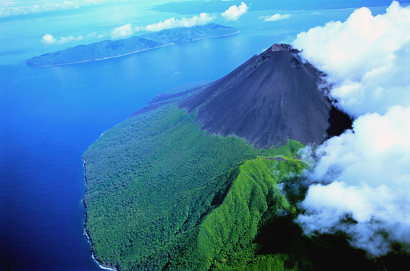
Vanuatu prepares evacuation amid threats of Gaua volcano

Image
Preparations are being made to evacuate nearly 3,000 people from the Vanuatu island of Gaua after further threats from its volcano.

The Gaua volcano in Torba province began erupting seven months ago and there has been renewed activity in recent weeks.

Government officials have been discussing the logistics of an evacuation, but no date has been set.

A Department of Internal Affairs meeting last Thursday concluded there was no alternative to evacuating the people of Gaua to Sola on Vanualava island.

From Sola most would be relocated to Leon Bay for up to a year, on land owned by the Anglican Church of Vanuatu.

Others would be dispatched to other islands in Torba.

Meteor

Evacuations planned in Vanuatu as Gaua activity steps up

Image
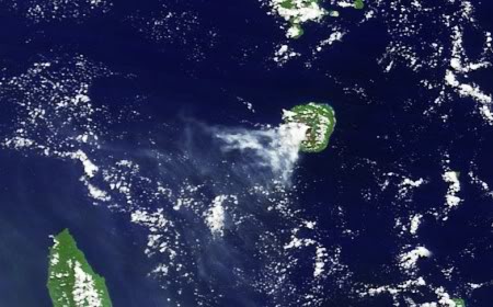
© NASA Earth Observatory, 15 April 2010Gaua volcano, Vanuatu: a MODIS image from the NASA Terra satellite, 12 April 2010
Gaua volcano in northern Vanuatu has been showing signs of increased activity for some months: in November 2009 there were evacuations of villagers from Gaua island because of ashfall and gas emissions. During January 2010 ash emissions became denser and darker, and gas emissions increased. Strombolian activity and explosions were reported at the end of January. From late March into April ash plumes were reported daily, reaching altitudes of up to 3 km, and reports of explosions, ash fall and the ejection of volcanic bombs continued.

Today news sources are reporting that extensive evacuations are being planned, involving the transfer of about 2700 people from Gaua or Santa Maria Island to a relocation centre on nearby Vanualava Island. According to Peter Korisa of the Vanuatu Government emergencies office the volcano's activity is not stable, but increasing: 'Last year it was just some explosions and some ash falling but at the moment the activity is becoming more interesting'. The evacuation is not yet being carried out, but the necessary plans have been made. At the moment, Korisa says, 'the situation doesn't warrant any evacuation', but the authorities are ready to act should such a step prove necessary.

Einstein

Is "Fossil Fuel" CO2 Different From Volcanic CO2?

We have all seen lots of pictures of the Eyjafjallajokull eruption now, with steam and ash billowing up in the air. The eruption started one month ago, and as the Guardian reports, The eruption of the Eyjafjallajokull volcano is unlikely to have any significant impact on climate but has caused a small fall in carbon emissions, experts say.

The Guardian editors seem to have forgotten that the volcano itself is spewing massive amounts of CO2 in the atmosphere. Perhaps their kinship with Plane Stupid is having an impact? Plane Stupid's goal is to stop plane traffic in the UK, and they must be thrilled by the flight ban and the damage to the economy.

Image
Natural CO2 Molecule

Image
CO2 From A Jet Engine
Volcano CO2 budget (CO2 is emitted independent of ash) ~200,000 tons per day X 30 days of eruption = 6,000,000 tons of CO2.

Plane CO2 Budget - assumes half of EU planes haven't flown for the past six days 340,000 EU tons per day X 0.5 EU shutdown X 6 days = ~1,000,000 tons of savings.

People using alternative transportation (as Anthony and the BBC pointed out) as a replacement for aircraft - cars, trains, battleships , etc. ~1,000,000 tons of extra CO2 Is a battleship more "green" than a jumbo jet?

The total gain is 6,000,000 - 1,000,000 + 1,000,000 = 6,000,000 tons of excess CO2 from the volcano. The temporary aircraft shutdown has little or no net impact on CO2 emissions, but the volcano has a large impact.

Satellite

New pictures of Iceland volcanic plume

Image
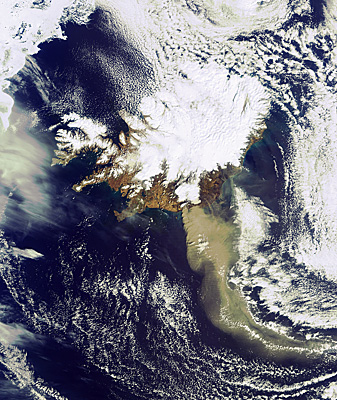
© ESANew satellite image of ash spewing from Iceland's volcano
In this image taken [at] (14:45 CET) by ESA's Envisat satellite, a heavy plume of ash from the Eyjafjallajoekull Volcano is seen travelling in a roughly southeasterly direction.

The volcano has been emitting steam and ash since its recent eruptions began on 20 March, and as observable, the emissions continue. The plume, visible in brownish-grey, is approximately 400 km long. Envisat's Medium Resolution Imaging Spectrometer instrument (MERIS) acquired this image on 19 April, while working in Full Resolution Mode to provide a spatial resolution of 300 m.

Radar

Ash cloud models - overrated? Airspace hysteria based entirely on computer calculations

Image
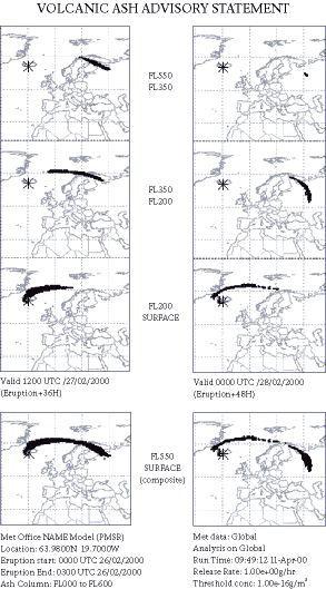
Figure 1. NAME prediction of the visible ash plume resulting from an eruption of Mount Hekla in Iceland on 16 February 2000.
"We sent ten Boeing 747 and Airbus 340 jets on transfer flights from Munich to Frankfurt," Lufthansa spokesman Klaus Walther told the paper. The planes were moved in order to be in the most useful place once the ban is lifted, he explained.

"Our machines flew to a height of 24,000 feet, or around 8,000 metres. In Frankfurt the machines were examined by our technicians. They didn't find the slightest scratch on the cockpit windscreens, on the outer skin nor in the engines."

"The flight ban, which is completely based on computer calculations, is causing economic damage in the billions. This is why, for the future, we demand that dependable measurements must be available before a flight ban is imposed."
Source: "the Local"

At left: the model from the Met Office used to look at dispersion. [Click on image for clearer rendition]

Bizarro Earth

US: Beached whale's stomach found to be full of fresh trash

A gray whale's last meal in Puget Sound included plenty of trash, and it was fresh enough to indicate the animal took the "eat local" mantra enthusiastically to heart before coming ashore at Arroyo Beach, and later dying about a mile south of the Fauntleroy ferry dock.

Trash in Whale Stomach
© CASCADIA RESEARCH COLLECTIVEBeached whale's stomach found to be full of fresh trash.

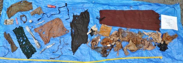
A gray whale that came ashore and later died near the Fauntleroy ferry dock last week had all that is pictured here in its stomach, all ingested while feeding in Puget Sound.
Sweatpants. A golf ball. Surgical gloves. Small towels. Bits of plastic. And more than 20 plastic bags.

A gray whale's last meal in Puget Sound included plenty of trash, and it was fresh enough to indicate the animal took the "eat local" mantra enthusiastically to heart before coming ashore at Arroyo Beach, and later dying about a mile south of the Fauntleroy ferry dock.

In 20 years of examining more than 200 whale carcasses, research scientist John Calambokidis says Tuesday he has never seen so much trash in a whale's stomach. Founding member of the Cascadia Research Collective in Olympia, Calambokidis says he does not yet know what caused the whale's death, and tests are continuing.

"It kind of dramatizes the legacy of what we leave at the bottom," Calambokidis said. The sediment at the bottom of Puget Sound bays is loaded with other contaminants, "and an animal feeding and being exposed to this kind of garbage is also being exposed to those, too."

Blackbox

Australia: Global search can't solve Dolphin mystery

Injured Dolphins
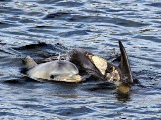
© Barbara SabertonHorrific burns on Port River dolphins - the cause may never be known.
The exact cause of the horrific burns inflicted on two Port River dolphins is unlikely to ever be known, despite a global search by local authorities.

The injured dolphins, Wave and her calf Tallula are being monitored daily by Port dolphin expert Mike Bossley and Adelaide Dolphin Sanctuary staff since the lesions on the upper flank of their bodies were first seen almost two weeks ago.

Dr Bossley, director of the Whale and Dolphin Conservation Society, said he was "more positive" about the dolphins likelihood of recovery, although the injuries were still a concern. "We've had responses from researchers and veterinarians from all over the world and it was universally acknowledged as the the worst ever injuries seen on a surviving dolphin," he said.

"I'm slightly more positive now that we've got to day 10 and they are still alive, because I feel if they were going to succumb they may have already by now.

"It would seem that Wave is feeding Tallula if Wave was too sick she couldn't provide milk but it is still a touch and go situation."

Environment Department animal welfare manager Deb Kelly ruled out any Port River industry or pollution as a cause of the burns.

However it wasn't possible to capture either dolphin to take skin samples to help determine the exact cause because it would be too distressing, she said.

Fish

Robin Hood meets his underwater match

Image
© Shelby Temple, University of QueenslandThwonk!
Species: Toxotes chatareus

Habitat: Coastal waters of the Asia-Pacific region, including Sri Lanka, India, New Guinea and northern Australia; typically in murky, brackish water, where they swim just under the surface.

Archerfish may not carry a bow and arrow, but all they need to shoot like one of Robin Hood's merry men is the chance to watch an expert at target practice.

The shimmering fish, with dashes of black on their silver flanks, are the sharpshooters of the estuaries and mangroves of Asia and Australasia. Having chosen an insect perching unawares on low branches as prey, they press their tongue against the roof of their mouth, snap their gills shut and squirt long shots of water from below the surface that knock the critter into the water. They can dislodge prey at distances of more than 10 times the fish's own length.

But it's not a matter of "shoot and hope" for the cunning archerfish. They fine-tune the size of their water jets to the size of their prey and how well the prey is gripping the surface it is standing on. In 2006, Stefan Schuster and colleagues at the University of Erlangen-Nürnberg in Germany showed that for any given size of prey, archerfish tuned their inbuilt water guns to hit the insect with 10 times the force required to knock it off its perch.