Earth ChangesS


Bizarro Earth

Cold snap in Chile puts summer citrus outlook in question

sun treat
© suntreat
A cold snap in Chile is leaving summer citrus importers unsure of what they'll be bringing to the states in upcoming weeks.

David Mixon, chief marketing officer for Seald Sweet LLC, Vero Beach, Fla., said Chile's citrus-growing areas had an unseasonable cold snap over the July Fourth weekend. Until the industry can measure the damage done to its crop, which can take a week or even 10 days, the forecast of exports to the U.S. is clouded.

Mixon said the temperatures recorded there indicate an "extremely high" likelihood of damage to the citrus, but "it's hard to predict how the fruit will react, and there's a lot of variables."

Chile's cold snap is just the latest weather hurdle for the industry. South Africa, which exported a record 1.5 million metric tons of citrus last season, dealt with a yearlong draught and hailstorms that will limit the nation's citrus exports by 5% from last year's record.

Better Earth

Japan in tsunami alert after new earthquake

Image
© euronews
A strong earthquake off the coast of northeastern Japan has triggered a tsunami warning and causing workers at the Fukushima nuclear plant to be evacuated.

The warning has now been lifted and there are no reports of significant damage.

Cloud Lightning

US, Florida: Heavy Rains in Pinellas County Caused Flooding Which Forced Nearly 150 People to Evacuate


Hours of torrential rain in Pinellas County began to take its toll Friday afternoon. One canal along Ulmerton Road in Largo began spilling into the Mariner's Cove mobile home park, and when it did, the water rose quickly.

Largo Police and Fire issued mandatory evacuation orders for the community of nearly 150 people. By the time the last few residents made it out, the water had already risen waist-deep in some places. People filled backpacks, grocery bags, whatever they could find, to take a few valuables with them.

Cloud Lightning

Alberta, Canada: Heavy Rains Cause Flooding Near Slave Lake, Highways Face Closure

Image
© Deanna WakefieldHeavy rainfall has caused high water levels in Slave Lake on July 8, 2011.
Heavy rainfall in Slave Lake has caused flooding to some highways in northern Alberta, and as a result, certain highways have been closed.

As of Friday afternoon, Highway 2 re-opened both east and west of Slave Lake, but the province says the following highways are still closed until further notice.
  • Highway 88 remains closed four kilometres north of the junction with Highway 2 north of Slave Lake. A detour is available in the northeast corner of the Town of Slave Lake from 12th Avenue to Tamarack Road.
  • Klondyke Ferry remains shut down, which carries Highway 661 traffic across the Athabasca River east of Fort Assiniboine.
  • Highway 33 north of Swan Hills is now closed from the junction with Highway 32 to the junction with Highway 2.
One car was stuck on the flooded highway Friday after water levels began to rise overnight.

Cloud Lightning

India: Heavy rains cool city of New Delhi, jams raise tempers

Several parts of the city and NCR, notably east and west areas, received heavy showers on Friday morning. The remaining parts of the city had to make do with light drizzle but pleasant temperatures of 28-32 degrees made up for the lack of rain.

The Safdarjung observatory recorded 2.8mm of rainfall till 5.30pm on Friday. The past 24 hour rainfall recorded at 8.30am was 5.2mm. There were reports of heavy showers in Gurgaon and short spells of heavy rain in South Extension, Maharani Bagh, Ashram and Pragati Maidan. The Lodhi Road and Ridge observatories recorded 0.6mm and 0.3mm of rainfall respectively.

The maximum and minimum temperatures were 30.2 degrees, six degrees below normal, and 27.4 degrees Celsius respectively. Humidity ranged between 75% and 87%. "The coming two days are expected to see widespread rain and isolated heavy showers. Monsoon showers need not be experienced similarly, with identical intensity over all parts of the city, so it is perfectly normal that some areas are getting heavier showers than the others," said the duty officer at the Met office.

Satellite

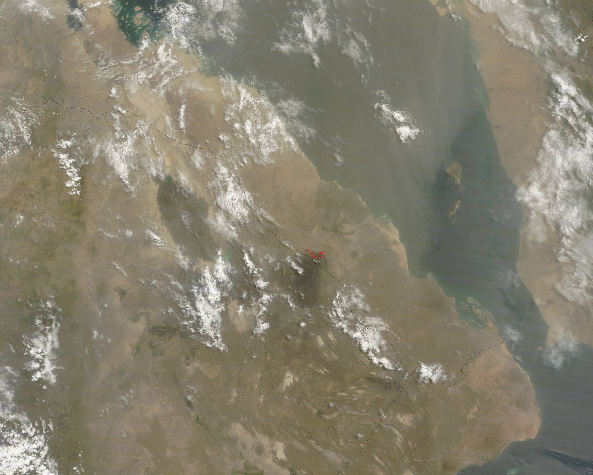
Three Active Volcanoes Spotted on Satellite Imagery from NASA

From space, NASA keeps a watchful eye on volcanic activity around the world with many satellites. NASA has just released satellite images showing activity this week from volcanoes in the countries of Eritrea, Chile and Indonesia.

NASA's Terra satellite and the GOES-11 satellite captured ash plumes or heat coming from the Nabro volcano, the Puyehue-Cordón volcano, and the Soputan volcano, respectively, over the past week. There are a number of other volcanoes showing activity around the world, but thanks to good visibility these three volcanoes were more easily seen from space this week.

NASA's Terra satellite flew over the Nabro volcano in Eritrea on July 6 at 07:50 UTC (3:50 a.m. EDT) and the Moderate Resolution Imaging Spectroradiometer (MODIS) instrument captured "heat signatures" or hot areas in the volcano. The MODIS images are created by the MODIS Rapid Response Team at NASA's Goddard Space Flight Center in Greenbelt, Md. The team provides images from the MODIS instrument (that flies on both the Terra and Aqua satellite) every day.

Nabro is located in the State of Eritrea, a country in the Horn of Africa. Eritrea's neighboring countries include Ethiopia to the south, Djibouti to the southeast and Sudan to the west. An ash plume was difficult to pinpoint on the imagery because of dust blowing in the direction of the volcano and over the Gulf of Aden from nearby Somalia.
Image
© NASA Goddard MODIS Rapid Response TeamNASA's Terra satellite captured this image of the Nabro Volcano located in the African country of Eritrea. The image was taken on July 6 at 07:50 UTC (3:50 a.m. EDT) and the red spots indicate heat. The light brown area over the Gulf of Aden (right) is blowing dust from northern Somalia (right) in the image.

Cloud Lightning

Florida, US: Heavy rains bring flooding and cancellations around Tampa Bay

Image
© Cherie DiezTeri Bowden of St. Petersburg leaves the Target store at St. Petersburg’s Gateway Mall in the rain with her five children, from left, Chloe, 8: Jonah, 6; Jayda, 9; Layla (in the cart), 8 months; and Sydney, 2. “I was out of diapers,” Bowden explained.
The heavy rains that fell around the Tampa Bay area caused flooding Friday, and lighter showers may continue today.

Pinellas County got 3 to 5 inches falling by late Friday afternoon, said Bay News 9 meteorologist Diane Kacmarik. In Hillsborough, Tampa International Airport likely broke a record 3.8 inches of rain, Kacmarik said. MacDill logged more than 6 inches at 5 p.m.

Some afternoon storms could form today, especially along the coast, Kacmarik said, but the worst is likely over.

"I don't think the rain will last as long or get as high as it did Friday," she said.

The downpour canceled events or closed them early, and brought troublesome flooding to low-lying areas.
Cloud Lightning

New Jersey, US: Salem County sees more than 2.5 inches of rain as heavy thunderstorms sweep through the area

Image
Heavy rain fell throughout Salem County Friday.
A strong line of showers and thunderstorms swept through Salem County on Friday, dumping more than 21⁄2 inches of rain.

A flash flood watch issued for Salem County by the National Weather Service was later upgraded to a flash flood warning as the rains came. The warnings were to remain in effect through the night.

A severe thunderstorm watch was in effect for the area most of the afternoon and into the evening.

As of 8 p.m. Friday, the storms had dropped 2.67 inches of rain in the county, according to official readings from the National Weather Service as recorded at the New Castle, Del., Airport, the closest NWS recording station to Salem.

A mid afternoon storm that brought heavy rain was followed later by another line that brought more rain that fell in torrents at times and thunder and lightning.

Cloud Lightning

US: Tornadoes reported across North Dakota

Tornadoes were reported across western North Dakota on Friday night, along with heavy rain and large hail.

One tornado was spotted on the ground a mile north of Underwood and others were seen about three miles northwest of Cannonball near the Cannon Ball River, a mile west of Beulah and reported 10 miles east of Halliday, National Weather Service meteorologist Tony Merriman said. Some of the sightings were of the same storm, he said.

The New Salem area had three-quarter-inch hail while a flash flood warning was issued for the Pingree area after more than 4 inches of rain fell there.

More than 4 inches of rain fell in several other places in short periods of time.

Cloud Lightning

US: Heavy rains flood streets, disrupt transportation, stall cars in Mid-Atlantic

Heavy rains have been wreaking havoc in the Mid-Atlantic region, flooding streets, stalling cars, delaying rail and air travel and canceling outdoor events.

Flash flood warnings were in effect Friday evening was Washington and much of Maryland. Firefighters in Washington rescued at least two people from vehicles stalled in water in Southeast.

ABC7News reported delays of at least an hour at the area's three airports. CSX and Norfolk Southern trains were ordered to reduce speeds.

In Frederick, sections of several streets were closed because of flooding.

In Maryland and Washington, utilities, already slammed by power outages caused by late Thursday's storms, worked to restore power as Friday's weather battered the area.