Earth ChangesS

Radar

6.5-magnitude quake hits N Japan

Image
© USGS
An earthquake with the magnitude of 6.5 has struck northern Japan around the same area that was affected by the March 11 quake and tsunami, geologists say.

The tremor hit at 1:34 p.m. (0434 GMT) off the Pacific coast of Miyagi prefecture, but no tsunami warning has been issued, AFP reported on Friday.

The Pacific Tsunami Warning Center said there was "no destructive widespread tsunami threat."

The earthquake happened at the depth of 40 kilometers (25 miles), Japan's Meteorological Agency said.

No damage or casualties have been reported yet.

The Tohoku Shinkansen bullet train service stopped operations due to the quake, but resumed shortly afterwards.

The epicenter of the quake was 125 kilometers (77 miles) northeast of Sendai city, Miyagi's capital, according to the United States Geological Survey.

Bulb

US, Florida: Severe Weather to Blame for Power Outages

clouds
© Scott B of W Melbourne
Intense showers and lightning moved into the Central Florida area Friday evening, causing some power outages.

A viewer, who shared a picture of what they called a 20 foot tree in their back yard, said that lightning cut it in half earlier in the day.

At the height of the stormy weather, Progress Energy said more than 3,000 customers were without power in the areas of Maitland and Casselberry, near SR 436 between Red Bug Lane and Lake Howell Road around 5:30 p.m. A spokesperson for the company said the outages were related to the severe conditions.

The company said power was expected to be out for about three hours.

Radar

Moderate unusual earthquake near Lake Kariba, Zambia: Is the man made lake to blame ?

Image
© unknown
Earthquake overview : Moderate shallow earthquake in a location with very few prior earthquakes. Earthquake-Report.com calls this earthquake moderately damaging as the houses are not prepared to resist earthquakes and as the epicenter location is surrounded by many villages.

22/07-08:17 UTC : Felt reports from the epicenter area. "It was very bad in itezhi tezhi, some buildings have developed cracks.Thanks heavens that no damage was done to humans so that we can VOTE (ER: there are soon elections in Zambia)." "The tremor was at 15:56 hours. Two of my office glass panes cracked."

22/07-08:06 UTC : In local media a fierce discussion is going on to find out why this earthquake happened. Some people blame the Itezhi Tezhi Dam project. Below are 2 people with a diffrent opinion on the origin of this earthquake.
Lemekani Phiri : "The tremor was located in Itezhi-Tezhi district. This is due to the man-made lake there. The weight of the new water body and lubrication of formerly idle faults by the water most likely caused it. And yes, Zambia has the ability to measure (so called Richter scale) and accurately locate the quake. Check with the Geological Survey Zambia. There have been such tremors infrequently since the completion of the lake construction."
"We've always have tremors in Zambia even before the Kariba was made. Its just that they are not as often as those in Asia and South Europe. In Zambia they are like a comet, a rare phenomenon. How do you explain the one that took place in Mocambique and Zim? I think it has something to do with the rift valley. The only advice I can give is for those building houses to put up strong ones. Let's take a leaf from Japan. Thank God no major damages nor serious injuries reported."
Bizarro Earth

UK: Rescue Operation Under Way After Three Whales are Beached in Sea Loch

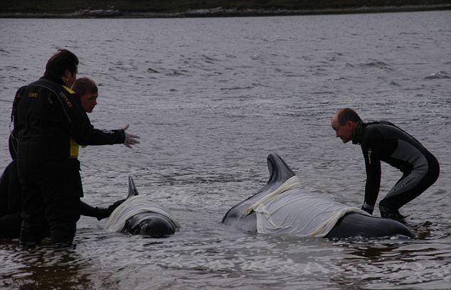
Three pilot whales became stranded on the shore of a remote Highland sea loch today.

Rescuers at the scene said the whales were part of a pod of around 60 which got trapped in the Kyle of Durness, one of Britain's most northerly points.

Beached Whales_1
© The Daily Mail, UKRescue divers administer first aid to two of the stranded pilot whales in the Kyle of Durness today.
The British Divers Marine Life Rescue charity said the three mammals were being given first aid on the beach.

Between 15 and 20 pilot whales which were thought to be in danger of stranding have been herded back to a deeper channel of water where they rejoined the larger group.

Beached Whales_2
© The Daily Mail, UKTwo members of the British Divers Marine Life Rescue charity herd up to 20 whales out to deeper water.

Bizarro Earth

US: Massive Lake County Sinkhole Continues To Swallow Building


Leesburg, Florida. -- A large sinkhole has been swallowing downtown Leesburg and many neighbors said they are concerned.

The sinkhole at Main and East streets has already gobbled up one business, and the damage is getting worse.

City leaders said the mess is in the hands of the landowner, and city officials said since it's only been a couple of weeks, they're not ready to issue any ultimatums.

Douglass Anderson has a good view of the sinkhole because it's just 50 paces from his Leesburg home.

"No. I don't think we've got to pull out. I think the thing is going that way," said Anderson, pointing away from his house.

The sinkhole opened at the corner of East and Main on June 27. "There's no indication that this hole has been growing," said Robert Sargent, Leesburg city spokesman.

Sargent said even though half the roof of Main Street Hair and Beauty Supply caved in, the width and depth of the pit remains the same. The sinkhole is 60 feet across and 20 feet down.

Bizarro Earth

Rare Sei Whale Spotted in Scottish Waters

Sei Whale
© Danny KerrDanny Kerr captured a shot of the whale between Islay and Gigha.
Scientists believe a rare Sei whale has been sighted in Scottish waters - possibly only the ninth such sighting here in the past 50 years.

The mammal was photographed by Scots paramedic Danny Kerr off the west coast, between Islay and Gigha, as he was flying to pick up a patient.

He later sent the image to the marine charity Sea Watch, which enlisted the help of two American academics.

All three independently concluded that it was a Sei whale.

Adult Sei whales can weigh between 20 and 30 tonnes and grow up to 19.5m in length.

Arrow Down

US: Sinkhole opens up in road, Charlotte, North Carolina

Image
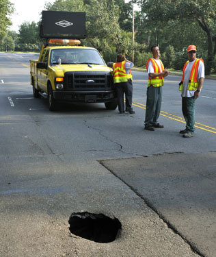
© DAVIE HINSHAW/charlotteobserver.comA DOT crew is on scene of a sinkhole that developed Friday morning on Sharon Road.
Police closed a south Charlotte intersection Friday morning after a sinkhole developed.

The sinkhole was on Sharon Road at the Wendover Road intersection. Motorists began reporting the problem shortly before 7 a.m., and authorities closed the intersection a short time later.

Inbound Sharon Road is open, but the outbound lanes are closed. In addition, there is no access to Sharon Road from Wendover Road.

Typically, these holes are caused by broken underground water lines that need repair. But it is unclear if that is the problem this time. State highway personnel arrived at the scene about 8:30 a.m.

Motorists should consider using Sharon Lane and Providence Road as alternate routes.

Cloud Lightning

Sweden: Record-breaking lightning in June


Comment: The following article is an abridged translation of an article published by the Swedish Meteorological and Hydrological Institute.


Image
© smhi.se
This June set a record in lightning strikes having currents greater than 5000 A. The Swedish Meteorological and Hydrological Institute (SMHI) reported on July 4th that
During June 2011, the lightning localization system registered around 122,000 discharges to the ground with electric currents greater than 5000 A. This is the greatest number registered during June month since the monitoring system began in 2002. The previous highest value was around 52,000 registrations, which was noted in 2002.
They note the significance of this in stating that the average number of these discharges registered for a whole year is 170,000, compared to 122,000 this June alone. Occurrences of lightning in June exceeded the total for 2005, as well as for 2007.

Bizarro Earth

Season for Mysterious 'Night-Shining' Clouds Is Here

Noctilucent Clouds
© Veres Viktor / NASA

Every summer since the late 19th century, Earth's polar skies have lit up with eerie blue-white glowing clouds, slowly twisting and undulating in the twilight sky.

These mystifying clouds are referred to as "night-shining" clouds, or noctilucent clouds.

Such clouds form in an upper layer of the Earth's atmosphere called the mesosphere during the summer and can be seen from the high latitudes on Earth.

Volcano drew attention

A series of massive eruptions from the Krakatau volcano (also spelled Krakatoa) in late August 1883 may have serendipitously helped to draw attention to the phenomenon of noctilucent clouds.

Dust and ash injected high into the atmosphere from the Indonesian volcano caused spectacular and colorful sunsets worldwide for several years.

On the evening of June 8, 1885, T. W. Backhouse was admiring one such beautiful sunset from Kissingen, Germany, when he noticed something rather strange: as darkness deepened and the ruddy glows faded, he noticed wispy bluish-white filaments seemingly glowing in the north and northwest sky. At that time, scientists dismissed this effect as some curious manifestation caused by the volcanic ash.

But after a few more years, the ash settled and the vivid sunsets induced by Krakatoa faded.

And yet the noctilucent clouds persisted.

Interestingly, there is some debate that Backhouse possibly was not the first to describe them, since in a report dated from 1854, Thomas Romney Robinson, situated at Armagh, Ireland, communicated his personal observation of the " . . . phosphorescent properties of ordinary clouds." So it might be that Robinson was making a reference to noctilucent clouds 31 years before Backhouse.

Bizarro Earth

Australia: Sydney Records its Wettest July in 50 years as Parts of NSW are Declared Disaster Zones

Wet Sydney_1
© James Croucher / The Daily Telegraph A Sydney lady braves the weather.
Parts of NSW have been declared natural disaster zones, as Sydney has experiences its wettest July since 1950.

Downpours are playing havoc with roads and public transport across the state, while floods have trapped people in their cars.

Police and Emergency Services Minister Michael Gallacher has added Lithgow, west of the Blue Mountains, Kiama on the south coast and the Illawarra city of Wollongong to the disaster list.

"These local government areas follow on the natural disaster declarations for the Blue Mountains, Shoalhaven, Oberon and Wingecarribee made on July 7,'' Mr Gallacher said.

Almost 23mm of rain has been measured at Observatory Hill in central Sydney since 9am (AEST) on Friday.

This has taken Sydney's July total to 244mm, making it the wettest July since 1950, when 336mm was recorded. That was the wettest year since Bureau of Meteorology records began in 1858.

The latest drenching means this month is now the 15th wettest July on record.