Earth ChangesS


Snowman

Another Dose of Frigid Air for the US

weather map
Setup Next Week: Cold East, Mild West
Just like last week, we have a storm system which will move from the Midwest to the East Coast over the weekend with a dump of bitter cold air following close behind.

Pictured to the right is the incoming large dip in the jet stream that will follow this storm and setup shop in the East. This will allow temperatures to fall 10 to 30 degrees below average during the weekend and into next week.

The opposite reaction is a bulge northward in the jet stream over the West, resulting in mild temperatures and some possible record highs.

Map: Current temperatures | Current wind chills

The first signs of this new chilly blast can be seen on the maps below over the Upper Midwest this weekend. Some cities will struggle to make it above zero during the day, including Minneapolis/St. Paul by Sunday.

By Monday and Tuesday, afternoon temperatures will range from the single digits, teens and 20s over the Midwest and Northeast to the 30s and 40s over the Southeast. The southern half of Florida may not make it out of the 50s or low 60s. Gusty northwest winds will make it feel even colder

No Entry

Snow, rain, wind cause havoc in Europe as the Eiffel Tower closes

eiffel Tower
© EPAThe tower was shut as salt cannot be used as it would damage the iron structure
Heavy snow blanketed Paris yesterday, forcing the closure of the Eiffel Tower and briefly shutting the city's main airport.

In Scotland sub-zero temperatures turned roads into deadly ice sheets.

In Spain and Portugal, cleaning-up has begun after floods and high winds. In Portugal, high winds blew away cars, uprooted trees, tore off roofs and knocked over power poles, leaving about 30 people injured. In Spain, a second body was recovered yesterday following flooding.

France's meteorological service said 11cm of snow fell in central Paris, the heaviest snowfall since 1987. About 100 flights were prevented from taking off or landing at Roissy airport during a temporary closure while workers cleared the runways.

Igloo

Forecasters warn Christmas could be cancelled as cold weather grips UK

snow,road
© ReutersForecasters warn Christmas could be cancelled as cold weather grips UK.
Christmas will have to be put on hold this year as the 'once in a lifetime' cold snap threatens to tighten its grip on ice-bound Britain, forecasters are warning.

Festivities are facing a white-out with the return of snow next week and Arctic conditions set to continue beyond the 25th.

It means drivers are being warned not to travel in the run-up to Christmas, when millions hit the roads to visit relatives or to do last-minute shopping.

Chaos across the transport network could mean gifts sent through the post do not arrive in time and shops will run low on food and other essentials.

Cloud Precipitation

Worse to come as Australia flood toll rises

australia floods
© AFPFloods sweeping across eastern Australia that have left four people dead
Floods sweeping across eastern Australia that have left four people dead and cost millions of dollars in crop losses could worsen next week, emergency officials warned Friday.

Some 30 regions have been declared natural disaster areas in New South Wales and more than 300 people have been isolated by the flood waters, but further storms are forecast for the nation's most populous state.

"The conditions are easing right now and over the weekend, but the flooding will potentially increase next week," a state emergency services spokesman told AFP.

Cloud Precipitation

Rains leave rising death toll in Colombia, Venezuela

tachira river
© AFPResidents stand next to a buliding damaged by the overflowing of the Tachira River
The toll from weeks of heavy rains across Colombia has risen to 174 people dead and over 1.5 million homeless, the Colombian Red Cross said Saturday.

And in neighboring Venezuela to the east, driving rains have triggered flooding and cave-ins that have killed 34 people over the past week and left an estimated 73,000 people homeless nationwide, officials said.

In Colombia, 225 people have been injured and 19 were missing, Colombian Red Cross deputy director of operations Cesar Uruena told reporters. A total of 1,821 homes have been damaged or destroyed.

Igloo

US: Monster storm predicted

Image
© Reed/Reuters
A huge storm followed by arctic cold threatened much of the upper quarter of the United States.

Forecasters predicted a monster storm this weekend -- possibly the worst of the season -- stretching from the Great Lakes to the central Appalachians, dumping snow and rain coupled with high winds over a wide area with blizzard conditions possible. Accuweather.com predicted poor travel conditions through much of the area but it was unclear where the rain-snow divide would come.

The snow is expected to begin over Iowa Saturday and then spread east and north, dumping 6 to 12 inches with higher amounts expected in lake-effect regions, possibly as much as 3 feet.

The Buffalo, N.Y.-area already has four feet of snow on the ground and in Western Michigan, 12 to 18 inches of snow has fallen since Sunday.

Sun

Science bulletin: 'Sun heats Earth!' Russian research forecasts global cooling

Habibullo Abdussamatov
© naHabibullo Abdussamatov

In a sharp rebuke to climate alarmists who believe human-generated carbon dioxide is responsible for causing catastrophic global warming, a Russian scientist has issued what amounts to a news flash announcing, "Sun Heats Earth!"

Habibullo Abdussamatov, the head of space research at St. Petersburg's Pulkovo Astronomical Observatory in Russia, has published a paper in which he tracks sunspot activity going back to the 19th century to argue that total sun irradiance is the primary factor responsible for causing climate variations on Earth, not carbon dioxide.

Moreover, Abdussamatov's analysis of sun-activity data has led him to conclude that the Earth is entering a prolonged cooling phase because sunspot activity is currently in a phase regarded as a "minimum."

Better Earth

Flashback Under Ice

ash drifts
© Reves-Sohn et al.; A. Soule and C. Willis/WHOI

Expedition yields first evidence of explosive volcanism on Arctic seafloor

A two-week cruise on an icebreaker to the top of the world last summer gave scientists a look at the aftermath of an event once thought impossible: a violent volcanic eruption on the deep-sea floor.

In 1999, a global network of seismic instruments detected the largest swarm of earthquakes ever to occur along the planet's system of mid-ocean ridges, where tectonic plates spread to form new ocean crust. Several aspects of the recorded vibrations suggested that the quakes were generated by volcanic activity, says Robert A. Reves-Sohn, a geophysicist at the Woods Hole Oceanographic Institution in Massachusetts.

However, he notes, many scientists have doubted that explosive volcanism can take place at the 4,000-plus-meter depth where these quakes occurred because the immense pressure of overlying water prevents seawater from flashing into steam, a major driving force for such eruptions.

Igloo

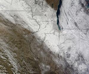
NASA Satellite Sees An Early Meteorological Winter In US Midwest

Image
© NASA Goddard MODIS Rapid Response TeamThe MODIS instrument on NASA's Terra satellite captured this image of snow on December 7, 2010 at 17:05 UTC (12:05 EST). Snow appears on the ground in eastern Minnesota and Iowa, southwestern Wisconsin, northern Illinois, much of Indiana, northern Kentucky and western Ohio. The white area over Lake Michigan and southeast into northern Indiana and Ohio are clouds.
NASA's Terra satellite captures daily visible and infrared images around the Earth and took a daytime image of a blanket of snow in the Upper Midwest this week. Even though astronomical winter is less than two weeks away, the central and eastern U.S. are already experiencing meteorological winter.

Meteorological winter is basically an identification of the winter season based on "sensible weather patterns" for record keeping purposes. That means "meteorological winter" happens whenever snow and ice occur, even before astronomical winter arrives on December 21, 2010. Astronomical winter is based on the position of the Earth in its orbit around the sun.

The residents of the upper Midwest are already feeling the effects of winter this week, with high temperatures in the 20s and 30s, and wind chills in the single numbers (Fahrenheit) or colder. The satellite image of snow on the ground in the upper Midwest is proof of an early meteorological winter.

It was captured by the Moderate Resolution Imaging Spectroradiometer or MODIS instrument on December 7, 2010 at 17:05 UTC (12:05 EST). MODIS is an instrument that flies aboard NASA's Aqua and Terra satellites.

Bizarro Earth

5.2 magnitude quake jolts different parts of Pakistan

Image
© USGS
An earthquake measuring 5.2 on the Richter scale jolted many parts of Punjab and KPK early Friday morning at 23:17 GMT on Thursday (04:17 a.m. Friday local time), the U.S. Geological Survey said.

The quake struck at 4:17 am with its epicenter 64 kilometres east of Zhob in Baluchistan, at a depth of 19 kilometers, the United States Geological Survey said. Tremors were felt in Faisalabad, Vehari, Jhang, Dera Ismail Khan as well as tribal areas. Unsettled by the sudden shocks, people came out of their houses, whereas no reports of any kind of losses have been received.

From USGS:

Date-Time:
Thursday, December 09, 2010 at 23:17:32 UTC

Friday, December 10, 2010 at 04:17:32 AM at epicenter

Time of Earthquake in other Time Zones

Location:
31.557°N, 70.140°E

Depth:
9.8 km (6.1 miles)