Earth ChangesS


Bizarro Earth

Solomon Islands - Earthquake Magnitude 6.9

Solomon Quake_230411
© USGSEarthquake Location
Date-Time:
Saturday, April 23, 2011 at 04:16:55 UTC

Saturday, April 23, 2011 at 03:16:55 PM at epicenter

Time of Earthquake in other Time Zones

Location:
10.349°S, 161.233°E

Depth:
81.6 km (50.7 miles)

Region:
SOLOMON ISLANDS

Distances:
76 km (47 miles) W of Kira Kira, San Cristobal, Solomon Isl.

173 km (107 miles) SE of HONIARA, Guadalcanal, Solomon Islands

184 km (114 miles) SSE of Auki, Malaita, Solomon Islands

2084 km (1294 miles) NNE of BRISBANE, Queensland, Australia

Bizarro Earth

US: 15 dead sharks wash ashore in Manatee County, Florida

dead sharks
© Photo/Anna Maria Island SunThree of the sharks found dead on Manatee County beaches.

A mystery is brewing on Manatee County's beautiful beaches -- researchers are trying to figure out why sharks are washing ashore dead.

Recently more than a dozen dead sharks were found on the north ends of Longboat Key and Anna Maria Island.

"There were no real indicators of what went wrong with them," Dr. Nick Whitney, Staff Scientist for the Center for Shark Research at MOTE Marine Laboratory said. "There are no obvious signs of damage from fishing or net damage or anything like that."

Cloud Lightning

US: Storms hit St. Louis airport, injuries reported

A vicious storm that included a possible tornado ripped through the St. Louis area on Friday night, closing down the city's airport where flying glass and blowing debris reportedly caused several injuries.

"We've had several reports of damage," said National Weather Service meteorologist Ben Miller. "We know the airport is closed. We're assuming that (a tornado) is what it was."

Video of the Lambert Airport in St. Louis shown on the Weather Channel showed an airport shuttle bus teetering over the ledge of a parking garage where it apparently was blown.

Flights from Lambert were being diverted to other airports.

Fish

US: Odd Animal Deaths, Deformities Linked to Gulf Oil Spill?

Image
© AnonymousA red snapper recently caught in the Gulf of Mexico displaying abnormal black markings.
Scientists befuddled by dolphin deaths, diseased fish.

On the first anniversary of the Gulf oil spill, scientists are observing strange deaths and deformities in animals that could be related to the disaster, experts say.

In the past six months, the numbers of dolphin and sea turtle deaths in the Gulf of Mexico (map) have risen, and some fish that inhabit the Gulf's coral reefs have developed abnormalities.

Yet projects to document and measure the oil's effects on Gulf marine life are still in the very early stages, scientists caution. Preliminary results may not be available for months, and it may be several years before any kind of scientific consensus is reached.

Such uncertainty is not unusual for oil-spill studies, noted William Patterson, a marine biologist at the University of West Florida (UWF) in Pensacola.

"If you look at the literature surrounding the Exxon Valdez oil spill [in 1989], there are still some unknowns associated with that," Patterson said.

Bizarro Earth

Europe Prays for Easter Rain in Worst Drought for a Century

Draught_1
© Yahoo NewsA farmer works on a field in his tractor.

The Dutch have banned barbecues, camp fires and outdoor smoking this Easter, while the Swiss are forecasting potentially the worst drought in Europe for more than a century.

Either way, prayers in Europe this Easter holiday weekend are as likely to call for rain as anything else -- with serious fears over the wheat harvest, its impact on already sky-high global food prices and, of course, devastating brush fires.

A year ago, it was Russia that bore the brunt of global warming, and with the price of benchmark wheat futures jumping by more than a fifth since the spring in the global market hub of Chicago, farmers everywhere are busy scanning the skies for soothing signs.

Traditional Easter fairs in the east and the north of the Netherlands have been cancelled because of the risk of fires posed by the extraordinarily dry weather affecting northern Europe, Dutch news agency ANP said.

In the eastern half of the country, one of Europe's biggest traders, outdoor family barbecues, smoking and camp fires are a strict no-no.

Alarm Clock

Earth opening up: Video of ground shifting during 3.7 earthquake in Japan April 10


Alarm Clock

Google Earth maps show populations at risk near nuclear plants

In a novel use of existing technology and data, Nature News in conjunction with Columbia University, has created a Google Earth map that shows the different population sizes surrounding nuclear power plants; ostensibly, to demonstrate the danger threshold of other plants worldwide, compared to the ongoing nuclear disaster at the Fukushima Daiichi plant in Japan.

nuclear plant risks
© UnknownGoogle Earth maps show populations at risk near nuclear plants
Working with the Power Reactor Information System (PRIS) database run by the International Atomic Energy Agency (IAEA) to pinpoint the location and size of nuclear plants, both existing and under construction, and Columbia University's NASA Socioeconomic Data and Applications Center, which runs the Global Rural-Urban Mapping Project, to nail down accurate population numbers, the team was able to put together a Google Earth map that very clearly shows, via colored circles, population density around nuclear facilities.

Because Google Earth maps render the globe in a 3-D like image, it's easy to skim around and very quickly get a feeling for where the dangers lie. For example, the United States, Europe (including Russia and former members of the USSR), India and China quite obviously have the bulk of nuclear plants, while the entire continents of Africa and South America have just one each, and Australia has none.

Comment: It's a telling sign that the article ends on a dismissive tone regarding the safety of human beings. This small piece of knowledge will, perhaps, allow some of those who are awake and paying attention to make choices that will protect them and their loved ones, just as those who were awake and paying attention left the Gulf Coast early on after the oil spill.


Cloud Lightning

US: Storms rip into central, southern Illinois

Image
© WGN-TV / April 20, 2011Storm damage near Litchfield, Ill.
Severe storms raked portions of southern and central Illinois late Tuesday, damaging homes, blowing rail cars off of tracks and leaving thousands of people without power.

Several tornadoes were reported, but there were no reports of injuries. The storm also pelted the region with golf ball-sized hail and driving rain.

More than 48,000 electric customers in central and southern Illinois are without power.

In northern Illinois, torrential rainfall and hail forced the cancellation of about 450 flights at Chicago's O'Hare International Airport. Midway International Airport was reporting delays of up to 30 minutes.

Some of the worst damage was in Girard, about 20 miles south of Springfield. Fire Chief Gary Otten says about 15 homes were damaged and many may be beyond repair. Otten said two barns also were destroyed.

"It's pretty clear to us it was a tornado - at least one, maybe two," said Girard Emergency Management Director Jim Pitchford.

The National Weather Service in Lincoln says it isn't yet clear if straight-line winds or tornadoes caused the damage. Trained weather spotters did report seeing funnel clouds and tornados.

Igloo

US: Temperatures Lowest For Time Of Year Since 1940s

Chicago - Not only has Chicago dealt with chilly rain, hail and even snow this week, but temperatures Tuesday were at their lowest for this late spring date since the 1940s.

CBS 2 Meteorologist Megan Glaros says the high Wednesday is expected only to reach 46 degrees with a peek or two of sunshine, but the chilly conditions will make it feel like winter never ended. As of 6:45 a.m., the temperature in Chicago was just 34 degrees.
Image
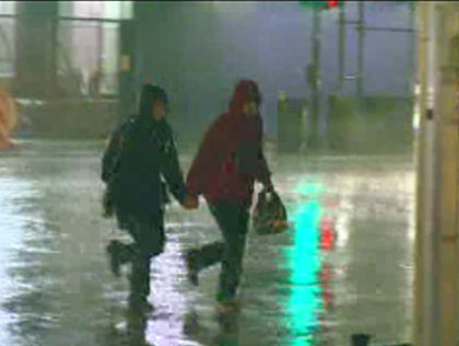
© Columbia Broadcasting SystemCold, pouring rain had people running downtown Tuesday night.
Glaros says if there were precipitation Tuesday morning, some snow would likely be mixed in. Fortunately, the storm systems have moved east and conditions were just cold and overcast.

On Tuesday, the high topped out at 38 degrees in the city. In the early evening hours, just walking a few blocks along the streets of Chicago felt like going out to sea in an open boat during a rainstorm in northern Canada. Anyone walking against the wind was blasted continuously in the face with cold droplets of rain, and given the strength of the winds, an umbrella was as good as useless.

And that was before the severe storms even hit. Lightning bolts and thunder claps soon appeared, and hail of up to 1 inch in diameter was spotted in some areas, according to the National Weather Service.

More than an inch and a half of rain fell in less than half an hour Tuesday evening, forcing the cancellation of more than 450 flights at O'Hare and Midway international airports, and leaving people sleeping on terminal floors.
Cloud Lightning

Ozone Hole A Surprise Rainmaker

Don't look now, but the climate problem we thought we had already solved -- the ozone hole over Antarctica -- has been rearranging rainfall patterns throughout the Southern Hemisphere for decades, a new modeling analysis shows.

ozone graphic
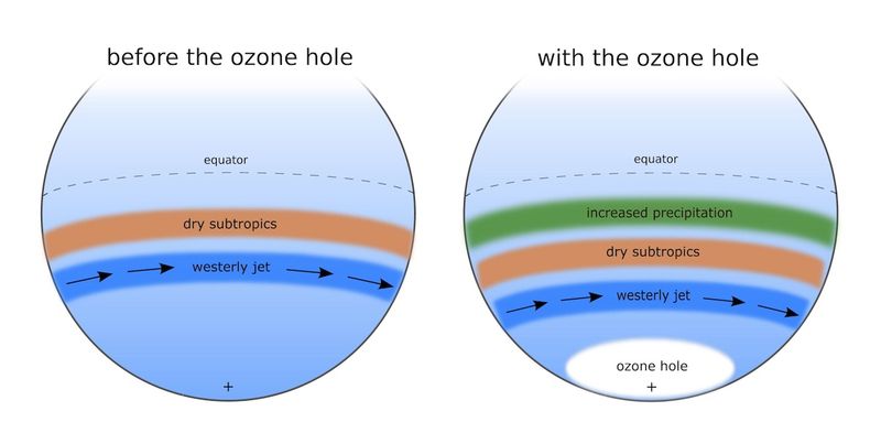
© Science/American Association for the Advancement of ScienceThe presence of the ozone hole moves the westerly jet and the dry subtropics towards the South Pole, leading to increases in subtropical precipitation.
The idea that losing ozone in the cold stratosphere over the South Pole could affect weather in the lower atmosphere all the way to the warm equator means Earth's changing climate system is even more complicated than most everyone thought.

The modeling study, published in the recent online issue of the journal Science, revealed that thinning of the ozone layer prompts severe cooling in the lower stratosphere over Antarctica. This cooling causes the lower level troposphere to rise and leads to a poleward shift in a strand of strong winds known as the westerly jet. Moving this jet stream pulls the storm track and other atmospheric circulation features farther south.