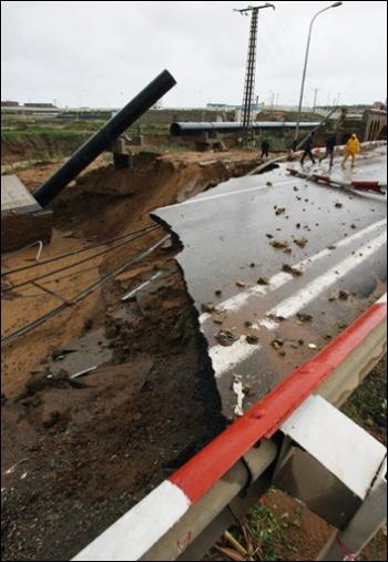
Earth Changes
This movement causes a buildup of stress within the ice. Under enough stress, the ice cracks or buckles in a cataclysmic process that resembles the energy released in earthquakes. These continuous ice quakes result in open leads of water or mountainous ridges of broken, jumbled ice. These deformations, in turn, may have an effect on the thickness and durability of the arctic ice pack in the face of climate change.
University of Alaska Fairbanks researcher Jennifer Hutchings hopes that a better understanding of this complex process will help improve climate models and shed light on how sea ice behaved in the past and how it may change in the future.
Tornadoes and the threat of tornadoes are a key part of the USA's spring weather because spring brings favorable tornado conditions. But tornadoes can occur any time of the year, during the day and at night.
![]() |
©NOAA Photo Library |
An F2 tornado roars near Seymour, Texas, in April 1979. F2 and F3 tornadoes are considered strong, packing winds of 113-206 mph that can cause major to severe damage. |
OKLAHOMA CITY - A tornado as wide as two football fields carved a devastating path through an eastern Colorado town as a massive spring storm swept from the Rockies into the Plains, killing at least four people in three states, authorities said Thursday.
Sixty-five tornadoes were reported in Oklahoma, Texas, Kansas, Colorado and Nebraska on Wednesday, the National Weather Service said.
Severe weather warnings and watches were in effect from South Dakota to Texas, as authorities warned residents to stay alert for tornado warnings.
When it comes to predicting weather events, however, particularly the extreme events - such as harsh winds, impact from massive wildfires or ash resulting from volcanic eruptions - those who work in the field face many challenges in creating models specific for Alaska's unique environment.
The article, which came out on Feb. 23, documents electrical activity that occurred during the January 2006 eruption of Mount Augustine. While it has long been known that volcanic eruptions can produce vigorous lightning, there are few direct observations of the phenomena, states the article. Following the initial eruptions of Jan. 11 and 13, 2006, two of which produced lightning, two electromagnetic lightning detectors were set up in Homer about 60 miles from Augustine. A couple of days later, the volcano erupted again, with the first of four eruptions producing a "spectacular lightning sequence."
Klyuchevskaya, one of the world's highest active volcanoes, rising to a height of 4,750 meters (15,584 feet), is emitting lava at an altitude of 4,200-4,300 meters (about 14,000 feet), the service said.
"The authorities should warn people about a possible danger and take proper security measures," said Alexei Ozerov, a senior seismology researcher, adding that the lava flow would grow more powerful.
Streams of lava with a temperature of about 1,100 C( (2,012 F() are encountering ice caps, producing powerful explosions of vapor. Experts are warning of devastating mudflows that can reach 500 meters (1,640 feet) in width and can descend the volcano's eastern slopes.
The clouds were bluish-grey with a distinctive cellular pattern of pouches.
They were hanging under another cloud base -- a sure sign of rain to come.
![]() |
©Mark Smith |
Menacing sky: mammatus clouds herald an approaching cold front. |
The researchers started by retrieving satellite data for two periods, 2000 and 2004. A digital field model was extracted for each of them, representing the topography of a ground reference point in digital form and therefore usable in computerized processing. The earliest topography of the area studied was provided by NASA which observed 80% of the Earth's surface during the Shuttle Radar Topographic Mission of February 2000. Then, in November 2004, two 2.5 m resolution images of the same area taken at two different angles were acquired especially by the French satellite Spot5 in the framework of an ISIS (CNES) project.
A new climate modeling study forecasts the complete disappearance of several existing climates in tropical highlands and regions near the poles, while large swaths of the tropics and subtropics may develop new climates unlike any seen today.
In general, the models show that existing climate zones will shift toward higher latitudes and higher elevations, squeezing out the climates at the extremes--tropical mountaintops and the poles--and leaving room for unfamiliar climes and new ecological niches around the equator.
The work, by researchers at the University of Wisconsin-Madison and the University of Wyoming, appears online in the journal Proceedings of the National Academy of Sciences (PNAS) during the week of March 26. The National Science Foundation (NSF) funded the research.
The most severely affected parts of the world span both heavily populated regions, including the southeastern United States, southeastern Asia, and parts of Africa, and known hotspots of biodiversity, such as the Amazonian rainforest and African and South American mountain ranges.