Earth ChangesS


Fish

New Zealand: Mystery pollution kills off fish life

A toxic discharge has killed more than 500 fish in a New Plymouth stream and those responsible could face a fine of $600,000.

Taranaki Regional Council resource management director Fred McLay said hundreds of fish were found dead in the Mangaone Stream.

"This is a major fish kill. There were too many to pick up," Mr McLay said.

It was not known where the pollution had come from but the council hoped to complete its investigations within 10 days.

This was not the first time the stream, which runs through a New Plymouth industrial area, had been affected by pollution, he said.

Bizarro Earth

Indonesia - Earthquake Magnitude 6.1 - Sulawesi

Sulawesi Quake_150211
© USGSEarthquake Location
Date-Time:
Tuesday, February 15, 2011 at 13:33:53 UTC

Tuesday, February 15, 2011 at 09:33:53 PM at epicenter

Time of Earthquake in other Time Zones

Location:
2.470°S, 121.541°E

Depth
20.6 km (12.8 miles)

Region
SULAWESI, INDONESIA

Distances
160 km (100 miles) ENE of Palopo, Sulawesi, Indonesia

200 km (125 miles) NNW of Kendari, Sulawesi, Indonesia

1500 km (930 miles) NW of DARWIN, Northern Territory, Australia

1680 km (1040 miles) ENE of JAKARTA, Java, Indonesia

Sun

Gust of solar wind brings sweet Valentine's auroras to Arctic Circle

Last night, as predicted, a gust of solar wind hit Earth's magnetic field, sparking bright Valentine's auroras around the Arctic Circle. Øystein Lunde Ingvaldsen sends this picture of the sweet lights over Bø in Vesterålen, Norway:

Image
© Øystein Lunde Ingvaldsen
"It was a short but beautiful blast of Northern Lights," says Ingvaldsen. "Perhaps this is a preview of things to come later this week." Indeed, a series of CMEs en route to Earth from exploding sunspot 1158 are expected to arrive on Feb. 15th-17th, prompting bright displays at even lower latitudes. Sky watchers should be alert for auroras.

Arrow Up

Hawaii: Lava lake at Halemaumau crater rising gradually, could spill out to crater floor

Image
The lava lake at Kilauea's Halemaumau crater has been rising gradually in the last few months.

Volcanologists don't know what the significance of the rise is. It's possible that the lava could spill out of the pit and on to the crater floor, though this might take months to happen.

The Hawaii Tribune-Herald reported the observatory's seismologists are also watching an increased number of earthquakes in the upper east rift zone.

Hawaiian Volcanoes Observatory scientist-in-charge Jim Kauahikaua says the increase in seismicity somewhat resembled the prelude to a brief June 2007 eruption in a remote section of Hawaii Volcanoes National Park. But there have also been several similar seismic episodes when nothing happened.

Kilauea is the world's longest continually erupting volcano. The east rift zone began erupting in 1983.

Radar

US: Quakes hit Mt. St. Helens, rattle Portland area

Image
Portland, Oregon - Two earthquakes hit the Mount St. Helens area Monday morning, and one was strong enough to be felt in the Portland-Vancouver area.

KATU received many reports from viewers in the Portland area who said they felt the 10:35 a.m. temblor.

The initial quake measured 3.5 and was followed by a 2.5., but then the first quake was re-evaluated as a 4.3 - a fairly robust temblor. A 2.3 aftershock struck just before noon.

Quakes are now measured on a "magnitude scale" instead of the Richter Scale, according to KATU News Meteorologist Dave Salesky.

Radar

Earth opening up: Erupting volcanic vents found in Antarctic waters

Image
© National Oceanography Centre.One of the new deep sea vents.
British researchers say the discovery of deep-sea volcanic vents in the Antarctic's Southern Ocean suggests they're more common than previously thought.

Deep-sea vents are hot springs on the seafloor, where mineral-rich water nourishes colonies of microbes and animals.

Around 250 such vents have been discovered worldwide in the three decades since scientists first encountered them in the Pacific. Most have been found on a chain of undersea volcanoes called the mid-ocean ridge but very few are known in the Antarctic, a release from the U.K. National Oceanography Center said Monday.

Sun

2nd M-Class Flares Now Earth Directed

Image
A second M-class in as many days has been unleashed from a different sunspot region named as 1158.

Equation: Sunspots => Solar Flares (charged particles) => Magnetic Field Shift => Shifting Ocean and Jet Stream Currents => Extreme Weather and Human Disruption (mitch battros 1998)

Watch for extenuating extreme weather over the next 72 hours. However, if further regions become active with M-class or larger flares, extreme weather phenomena will continue as related to time-linked means.

Bad Guys

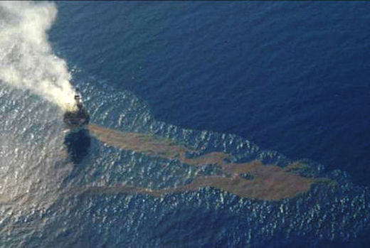
Study Finds Massive Flux of Gas, in Addition to Liquid Oil, at BP Well Blowout in Gulf

BP oil spill aerial shot
© unknown
A new University of Georgia study that is the first to examine comprehensively the magnitude of hydrocarbon gases released during the Deepwater Horizon Gulf of Mexico oil discharge has found that up to 500,000 tons of gaseous hydrocarbons were emitted into the deep ocean. The authors conclude that such a large gas discharge - which generated concentrations 75,000 times the norm - could result in small-scale zones of "extensive and persistent depletion of oxygen" as microbial processes degrade the gaseous hydrocarbons.

The study, led by UGA Professor of Marine Sciences Samantha Joye, appears in the early online edition of the journal Nature Geoscience. Her co-authors are Ian MacDonald of Florida State University, Ira Leifer of the University of California-Santa Barbara and Vernon Asper of the University of Southern Mississippi.

The Macondo Well blowout discharged not only liquid oil, but also hydrocarbon gases, such as methane and pentane, which were deposited in the water column. Gases are normally not quantified for oil spills, but the researchers note that in this instance, documenting the amount of hydrocarbon gases released by the blowout is critical to understanding the discharge's true extent, the fate of the released hydrocarbons, and potential impacts on the deep oceanic systems. The researchers explained that the 1,480-meter depth of the blowout (nearly one mile) is highly significant because deep sea processes (high pressure, low temperature) entrapped the released gaseous hydrocarbons in a deep (1,000-1,300m) layer of the water column. In the supplementary online materials, the researchers provide high-definition photographic evidence of the oil and ice-like gas hydrate flakes in the plume waters.
Cloud Lightning

Australia: Towns in WA's east flooded after heavy rains

Image
© unknownWarburton received twice its monthly rainfall in a day
More than 20 residents in the Eastern Wheatbelt town of Nungarin have been forced from their homes by flash flooding.

The town has received more than 100 millimetres of rain in five hours.

The Shire of Nungarin says the heavy rain has caused damage to local infrastructure and inundated the entire road network.

Nungarin Shire's Chief Executive, Bill Fensome, says many residents had to sandbag their properties.

"Like a river that you wouldn't believe, we had to drag one of our residents out of his house, an elderly gentleman, the water pressure trying to get him out was unbelievable," he said.

Local farmer Garry Coombs says the rain is continuing to fall.

"And I went and looked in the gauge at 7pm. It hasn't let up for the last two and a half hours, it's just been constant rain," he said.

Meanwhile, residents of the remote Aboriginal community of Warburton are in recovery mode after a flash flood inundated the community.

83 millimetres of rain fell on the town yesterday flooding parts of the town to two metres.

Bizarro Earth

4.3-Magnitude Earthquake Near Mount St. Helens is Biggest in 30 years

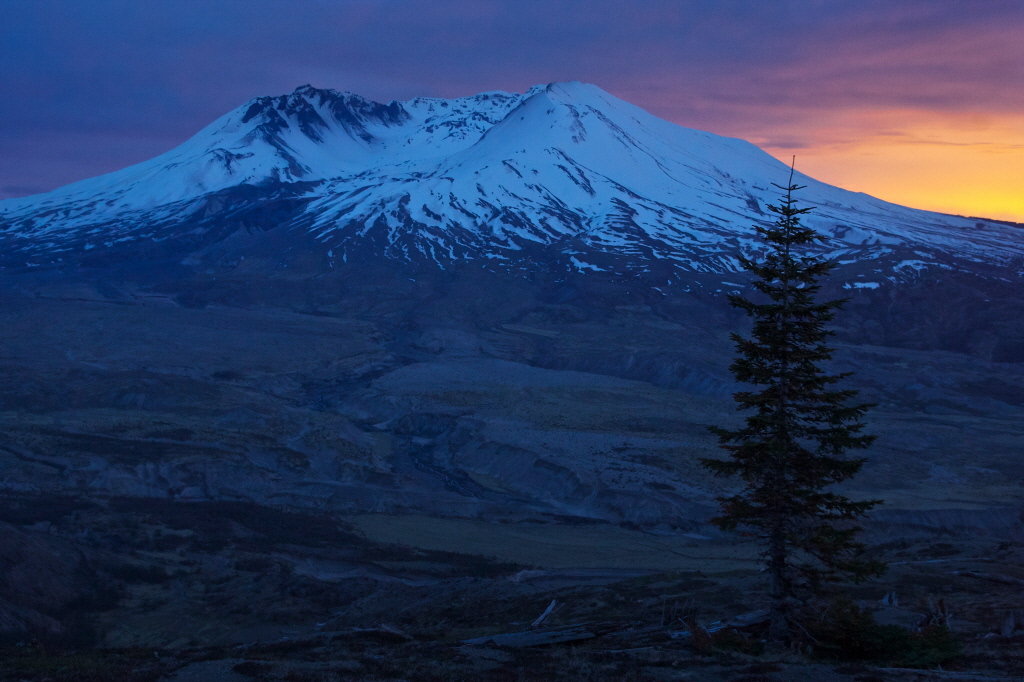
Mount St. Helens
© Bruce Ely/The Oregonian/2010View of Mount St. Helens from the north side at Johnston Ridge after sunset.

Fault line, won't you be my Valentine?

The second largest earthquake since Mount St. Helens erupted -- a magnitude 4.3 shaker -- rocked a fault line six miles north of the volcano Monday morning. People felt it as far away as Astoria, Lake Oswego, Hood River and even Bremerton, Wash., near Seattle.

The last one, as it happens, was 30 years ago also on Valentine's Day, a magnitude 5.5 temblor.

That 1981 earthquake appeared to be the result of the earth's crust readjusting after magma oozed up through the fault and blew the mountain's top on May 18, 1980.

Monday's quake was of the "strike-slip variety," said seismologist Seth Moran of the Cascades Volcano Observatory in Vancouver.

The large tectonic Juan de Fuca plate is diving beneath the North American plate. At places, the plates get stuck together. An earthquake occurs when the plates slip past each other, releasing energy, he said.