Earth ChangesS


Igloo

Prelude to Ice Ages: Volcanoes cause more rain than previously realized

Image
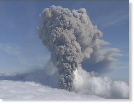
© APIn this aerial image from video made Saturday May 8 2010, a renewed column of ash rises from Iceland's Eyjafjallajokul volcano.
Volcanoes may release particles that can cause changes in local and regional weather at rates up to 100 million times higher than previously realized.

The eruption last spring of Iceland's Eyjafjallajökull volcano provided French scientists with the perfect natural laboratory to measure the levels of weather-changing particles released in such eruptions. Taking measurements at the Puy de Dôme research station in central France, they found was that the eruption released much larger amounts of particles at low levels in the atmosphere than previously known.

Volcanoes typically create two types of particles, big primary particles that quickly fall to the troposphere, the lowest portion of Earth's atmosphere, and smaller secondary particles, mostly composed of sulfuric acid, that react chemically with other molecules in the atmosphere and which are responsible for both local and global precipitation changes.
Comment: Bingo!

SOTT has been saying that increased vulcanism is behind the increased precipitation for some time now.

Cosmic Climate Change is Underway
Eyjafjallajokull's eruption is another significant marker as we approach catastrophic climate change brought on by the build-up of comet dust in the upper atmosphere. The marked increase in the number of strong earthquakes and volcanism strengthens SOTT's hypothesis that the planet's rotation is slowing down, however slightly, weakening the magnetic field and thus literally "opening up" the planet.

Bear in mind that most volcanoes are underwater, so as they warm the planet's oceans more water is evaporated into the atmosphere where it meets the cooling upper atmosphere and precipitates rapidly as deluges of rain - or, as we've seen above, as snowfall where there shouldn't really be any. We are approaching a tipping point where the feedback loop rapidly locks the planet's climate cycles into ever-increasing precipitation falling back as snow. When we also factor in the low solar activity (sunspot numbers are at a 90-year low) and the planet's intensified water cycle (caused by the warming oceans), an abrupt system shift into a new Ice Age is in the cards. I don't dare call when this will happen, but I'm not alone in thinking that it will happen soon - very soon.


Camera

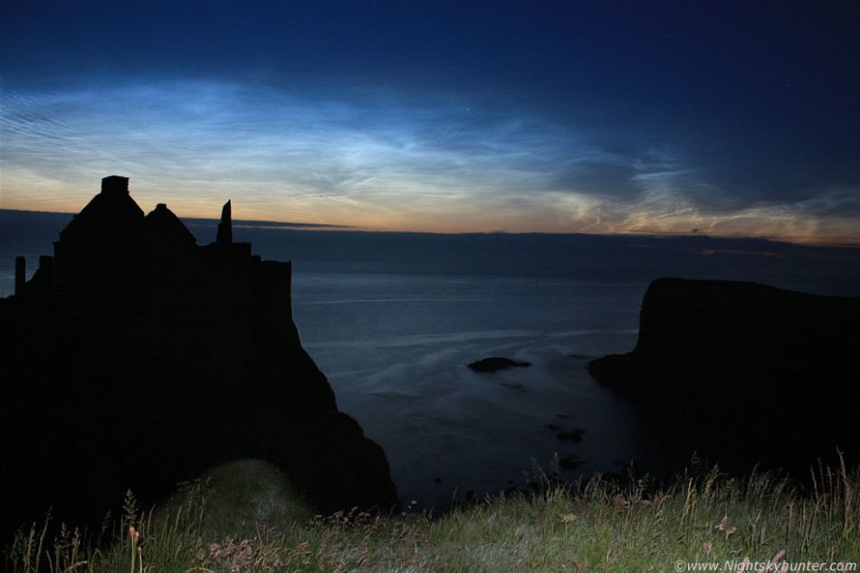
Best of the Web: The Harbingers of Change Can Now Be Seen All Around the World! Mysterious Noctilucent Clouds Brighten Up Night Skies

Image
© Martin McKenna/SpaceweatherNLC photographed near Dunluce Castle, Co. Antrim (North Coast), N. Ireland on July 9, 2011.
The season for spotting Noctilucent Clouds or the "night-shining" clouds has begun, NASA said in a statement in early July.

Noctilucent Clouds are composed of tiny ice crystals 40 to 100 nanometers wide, which is just the right size to scatter blue wavelengths of sunlight, a NASA scientist explained.

According to NASA, the best time and location to search for these breathtakingly beautiful phenomenon would be between mid-May and the end of August in the northern hemisphere. However, with no explanation yet found, these glowing, mystical clouds have been seen even as far south as Utah and Oregon and Denver, Colorado in the recent years.

Comment: For the possible explanation, read the comment at the end of the article.

Noctilucent Clouds were first observed in 19th century but their appearance has increased over time and are seasonal, appearing most often in late spring and summer every year.

Comment: Let us suggest a reason for why instances of noctilucent clouds are increasing and intensifying.

What we suspect has been happening, based on our research thus far, is that the upper atmosphere is cooling because it is being loaded with comet dust, which shows up in the form of noctilucent clouds and other upper atmospheric formations.

Magnificent and mesmerizing noctilucent clouds (also called polar mesospheric clouds), were once considered to be rare. But now they are puzzling scientists with their recent dramatic changes. Apparently, the clouds are growing brighter, are seen more frequently, are visible at ever lower latitudes and are now appearing even during the day. If scientists were allowed to conduct honest interdisciplinary research, such changes wouldn't be a mystery.

They would be able to figure out that comet dust is electrically-charged which is causing the earth's rotation to slow marginally. The slowing of the rotation is reducing the magnetic field, opening earth to more dangerous cosmic radiation and stimulating more volcanism. The volcanism under the sea is heating the sea water which is heating the lower atmosphere and loading it with moisture.

The moisture hits the cooler upper atmosphere and contributes to a deadly mix that inevitably leads to an Ice Age, preceded for a short period by a rapid increase of greenhouse gases and "hot pockets" in the lower atmosphere, heavy rains, hail, snow, and floods.


Attention

US: Russell Springs, Kansas - Unusually Harsh Weather Conditions Cause Exceptionally Rare Hibernation Period in Prairie Dogs

Image
© Mike Corn • Hays Daily NewsA young prairie dog is pictured last Friday in Logan County. Prairie dog numbers appear to be down as a result of unusually harsh weather that sent the animals into a rare hibernation
The unusually harsh weather conditions that sent black-tailed prairie dogs underground for what is believed to be an exceptionally rare hibernation period continues to affect the health of the animals.

Population estimates over at the Smoky Valley Ranch owned by the Nature Conservancy, for example, are considered to be about half of normal.

"I suppose it's about that way here," said Larry Haverfield, whose ranch south of Russell Springs has the largest concentration of prairie dogs in the area, and, as a result, the largest population of the highly endangered black-footed ferrets.

Haverfield said the first prairie dog pups of the year were spotted May 25, perhaps as many as 20 days later than normal.

Even then, the number of young in a litter appear to be fewer than normal.

Cloud Lightning

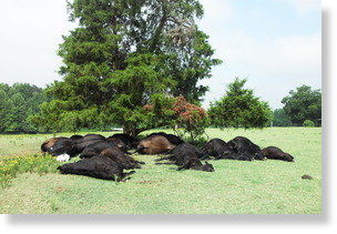
US: Richmond County, North Carolina: Lightning kills 20 cows

Image
© Unknown20 of Wesley and Sammy Anderson’s Angus cows were killed by lightning on Wednesday afternoon
A lightning storm Wednesday afternoon claimed the lives of 20 Angus cows belonging to Wesley and Sammy Anderson, of Ellerbe.

The cows congregated underneath a tree when the storm rolled in, and were killed when lightning struck and traveled through the group.

"We're fourth generation farmers, and my dad and I don't ever remember seeing anything like this," said Sammy. "I've heard of cows being hit standing in ponds, but not this many - and I've never seen it myself."

Sammy said that it's normal for cows to congregate under trees during storms.

Sun

US: Record Temperatures Seen as Heat Wave Plagues 23 States


A heat wave is building and could reach dangerous levels in parts of the Midwest, the Plains and the Southeast this week.

Twenty-three states were under heat advisories Monday, according to the National Weather Service.

Kansas City, Missouri, and St. Louis are under an excessive heat warning, along with Tulsa, Oklahoma; Memphis, Tennessee; and Evansville, Indiana. In these areas, the heat index, or how hot the body feels due to the combined effects of heat and humidity, will reach between 110 and 115 degrees this week.

A 51-year-old man in Granite City, Illinois, died Sunday due to the excessive heat, the Madison County coroner said. Mitsunari Uechi was found unresponsive in his mobile home, where the air conditioning was not working. Police described the residence as "extremely hot," Coroner Stephen Nonn said in a statement.

Uechi was transported to Gateway Regional Medical Center with a body temperature of 104 degrees. He was later pronounced dead, according to the coroner.

Arrow Down

US: Lenoir, North Carolina sinkhole evidence of a possible wider problem

Image
© WBTV
Lenoir, North Carolina - A small sinkhole in Lenoir was much bigger than officials thought.

When work crews began digging on Monday they found that hole that was just a foot wide at the surface of the pavement, was more than twelve feet wide under the pavement.

"The pavement was holding itself up," said Streets maintenance Supervisor Estel Osborne. Pennton Avenue was closed last week as a precaution when the problem was discovered and Osborne said it was lucky they did keep cars off of the spot. "There was nothing under the asphalt."

Crews on Monday cut out a forty foot section of the road to get to the drainage problem that caused the sinkhole in the first place.

"There's an old pipe in there and the bottom of the pipe just rusted out." The pipe carries water from an old creek under the roads and buildings in the area.

Comment: Oh this goes WAY beyond the city's drainage system rusting out! Think on a global scale...

Australia: Enormous sinkhole swallows south-east Queensland Rainbow beach

A collection of sinkhole images from around the world

Huge sinkhole appears in Germany! Usedom Island has a Grand Canyon now

Update: Tropical storm leaves more than 115 dead and a huge sinkhole in Central America


Cloud Lightning

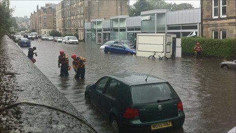
Scotland: Homes and cars flooded in Edinburgh downpour

Image
© BBCWitnesses said cars in Balcarres Street were bobbing about in the water
Homes, businesses and cars have been hit by flooding during a heavy downpour across Edinburgh.

Witnesses have been reporting cars floating in deep rivers running down roads in Morningside, Colinton and Oxgangs.

One resident in Balcarres Street said her ground-floor-flat had been ruined following the flash flood at 1440 BST.

Emergency council teams have been deployed in a bid to help firefighters deal with the "huge volumes of water".

A resident in Balcarres Street added that the fish in her pond in her front garden had been washed away in the flood water.

A 31-year-old witness said: "I have never seen anything like it. There was such a huge volume of water in Balcarres Street that buses were trying to plough through it and the wake was causing the cars at the side of the road to crash into each other.

"There is also a car showroom in the street, which has been flooded."

Arrow Down

US: Massive sinkhole opens up in Daisetta, Texas


Comment: The above is one we missed from 2008, but this report came in today, 12 July 2011:

US: Lenoir, North Carolina sinkhole evidence of a possible wider problem

These reports are from just the past month:

South Carolina, US: Sinkhole Closes Stephens County Boat Ramp

U.S.: Fairfield Township deals with sinkhole

Enormous sinkhole swallows south-east Queensland Rainbow beach

Canada: Downpour Leaves 18-metre Sinkhole in Ontario Highway

Australia: Sinkhole swallows south-east Queensland beach

North Dakota, US: Sinkhole closes Fargo overpass

US: 45' deep sinkhole appears in Pittsburgh parking lot

Big Apple, Cracked! New York, US: Midtown sinkhole stops rush hour traffic, baffles investigators

A collection of sinkhole images from around the world

The planet is literally opening up!


Bizarro Earth

Sicily, Italy: Etna Volcano Erupts Again on July 9 2011

UPDATE 09:45 UTC : Due to the volcanic activity and the ash concentration in the air, the (important) regional airport of Catania was closed since yesterday 18:12 (6:12 PM). The airport reopened this morning at 07:00 ( 7 AM).

UPDATE 08:00 UTC : As stated below, the densely populated Catania area got a lot of ash showers covering cars and roofs with a gray layer.

UPDATE : One video tells more than a 1000 words. This YouTube video was recorded by Klaus Dorschfeldt alias KdEtna. We encourage our readers to take a look at his great Etna Channel on YouTube. The strong eruption was short-lived (see in-depth text below), which explains why there are only daylight videos from this eruption

Cloud Lightning

US: New Mexico Rains Douse Flames But Fuel Flood Fears

The monsoons arrived on schedule in northern New Mexico on Monday, bringing with them the promise of containing a monster wildfire that has broken records in the state.

But they also brought potential peril from flash floods, wind bursts and lightning, with possible flooding made worse by the ground-clearing fires.

"It's such a Catch-22 with the rains," said Arlene Perea, a fire information officer. "The rains are welcome, but we know there are some problems with it."

The National Weather Service on Monday put out a flash-flood watch for the fire area through at least Wednesday. Forecasters said showers and thunderstorms were expected, with hail, lightning and winds up to 45 miles per hour.